Tianshuihai
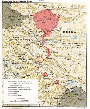
Tianshuihai[2][3] (Chinese: 甜水海), alternately Tien Shui Hai,[4] is the location of an army service station[5][6] in the disputed Aksai Chin region of Kashmir administered by China as part of its Hotan County,[7] Hotan Prefecture, Xinjiang Uyghur Autonomous Region. It is also claimed by India as part of Ladakh.
Tianshuihai
甜水海 | |
|---|---|
army service station | |
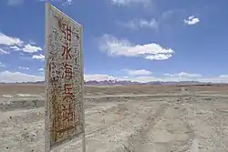 Tianshuihai Army Service Station signage | |
 Tianshuihai 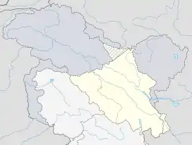 Tianshuihai | |
| Coordinates: 35.297°N 79.561°E | |
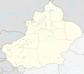
| Country | China |
| Province | Xinjiang Autonomous Region |
| Region | Aksai Chin |
| Elevation | 4,850 m (15,910 ft) |
| Tianshuihai | |||||||||
|---|---|---|---|---|---|---|---|---|---|
| Traditional Chinese | 甜水海 | ||||||||
| Simplified Chinese | 甜水海 | ||||||||
| Literal meaning | sweet water sea | ||||||||
| |||||||||
Toponymy
The name Tianshuihai means "sweet water sea" in Chinese, supposedly originating in local army folklore about a dying soldier whose last words before passing were that he wanted to taste sweetened water.[8]
Service station
The service station is located at an elevation of 4,850 metres (15,910 ft).[1] Due to this high elevation, there are few inhabitants in the remote area. Since the 1990s, there were numerous attempts by outsiders to establish restaurants or businesses in the area, but so far most have failed. While legally not permitted to accommodate outsiders, given the harsh environment, when not accommodating army personnel, the army service station would offer food and lodging to civilians for a relatively expensive price.[5][9]
Lake
There is a lake by the same name nearby, Lake Tianshuihai. It has a depth of 56.32 metres (184.8 ft).[10] All the lakes in the region are saltwater lakes.[11] Geologically, the area is part of a terrane that was formed in early Mesozoic.[12]
Transportation
China National Highway 219, known as the Xinjiang–Tibet highway, passes nearby, connecting it with Lhasa and Kargilik County. The outpost is 575 kilometres (357 mi) from the starting point of National Highway 219 in Kargilik County.[13] The next settlement northward along the highway is Dahongliutan. The next settlement southward along the highway is the rest stop at Quanshui Lake in Tibet.
The service station was constructed in 1959.[13] During the Sino-Indian War in 1962, Tanshuihai region served as the main communication artery for 3 fronts of the Chinese offensive.[14]
References
- Anna Orton (2010). India's Borderland Disputes: China, Pakistan, Bangladesh, and Nepal. Epitome Books. pp. 18–. ISBN 978-93-80297-15-6.
The China National Highway 219 ... passes through no towns in Aksai Chin, only some military posts and truck stops, such as the very small Tianshuihai (el. 4,850 m (15,900 ft)) post.
- Concise World Atlas (6 ed.). Dorling Kindersley. April 2013. p. 150. ISBN 978-1-4654-0227-1 – via Internet Archive.
Tianshuihai
- Collins World Atlas Illustrated Edition (3rd ed.). HarperCollins. 2007. p. 82. ISBN 978-0-00-723168-3 – via Internet Archive.
Tianshuihai
- Avouac, Jean-Philippe; Dobremez, Jean-François; Bourjot, Laurence (1996). "Palaeoclimatic interpretation of a topographic profile across middle Holocene regressive shorelines of Longmu Co (Western Tibet)". Palaeogeography, Palaeoclimatology, Palaeoecology. 120 (1–2): 93–104. doi:10.1016/0031-0182(96)88700-1. ISSN 0031-0182.
based on meteorological data collected at Tien Shui Hai
- "45 Days Ride along Dragon's Backbone: Kashgar to Lhasa". TibetTour.org. Retrieved 30 December 2019.
the last stop in Xinjiang, the tianshuihai [sic] Army Service Station, which is the highest Station in China. It is expensive to stay overnight at the Army Service Station, so we suggest that you camp nearby.
- Tibet. Lonely Planet (7 ed.). February 2008. p. 2,339 – via Internet Archive.
Tianshuihai{...}From here the road turns south, and climbs to the Khitai Pass (kilometre marker 535; 5150m), past the military base of Tianshuihai.
- 地貌气候. 和田县政府门户网站 (in Chinese). 29 April 2019. Retrieved 23 December 2019.
和田县境内有主要湖泊5处:{...}甜水海;
- 陈金财; 徐俊 (2016-12-07). 杜麒麟; 孙和静 (eds.). "走进天路兵站甜水海 体会官兵生活的苦与乐" [Enter the army outpost Tianshuihai on the skyward road, experience the hardship and joy of army life]. 中国陆军网 (in Chinese). army.81.cn. Retrieved 13 December 2019.
甜水海的来历,曾有这样一个故事:过去,站里有名老兵,临终前紧紧拉着老站长的手说,我想喝口甜水,说完便闭上了眼睛。后来,甜水海这个名字便成了历代官兵最美好的精神寄托。 ... 从1959年建站起,兵站所有的生活用水,都要到90公里外的“死人沟”泉水湖去拉,来回一趟至少6个小时,如果到了冬季,还得破冰取水。
- "骑行新藏线d7:红柳滩k486-奇台达坂k536-泉水沟k546-甜水海k592". 不止骑行川藏线攻略 (buzhiqixing.com) (in Chinese). 2019-03-11. Retrieved 28 January 2020.
根据国家的法律法规,兵站是不允许接纳外人,靠近兵站属于违法行为,考虑到新藏线旅行的情况,兵站对求助者进行一定程度的接纳,作为礼尚往来,一定要知道感激和礼貌,注意言行举止。
- Zhu, Zhaoyu; Ku, Teh-Lung; Luo, Shangde; Zhou, Houyun; Wen, Qizhong; Li, Shijie; Li, Bingyuan; Li, Hongchun (2001). "Age dating of lacustrine sediments in Lake Tianshuihai of the Tibetan Plateau by using U-series isochron method and its significance". Chinese Science Bulletin. 46 (10): 862–866. doi:10.1007/BF02900440. ISSN 1001-6538.
- "新藏线第七天,甜水海至死人沟,骑行在海拔5000米的公路上". 世间彩虹丽日升 (in Chinese). Sina. 2019-09-09. Retrieved 13 December 2019.
甜水海一路过来都是咸水湖
- Rui, Zongyao; Goldfarb, Richard J.; Qiu, Yumin; Zhou, Taihe; Chen, Renyi; Pirajno, Franco; Yun, Grace (2002). "Paleozoic–early Mesozoic gold deposits of the Xinjiang Autonomous Region, northwestern China". Mineralium Deposita. 37 (3): 393–418. doi:10.1007/s00126-001-0243-6. ISSN 0026-4598.
They are predicted to have formed in the Tianshuihai terrane during its early Mesozoic accretion to the amalgamated Tarim–Qaidam–Kunlun cratonic block.
- 陈劲松 (2001-08-24). "甜水海人的本色" [The true character of people from Tianshuihai]. People's Daily (Overseas Edition). Retrieved 13 December 2019.
甜水海兵站,距新藏公路的起点—新疆叶城的零公里处,是575公里。这里海拔4890米,是人民解放军海拔最高、气候最恶劣、条件最艰苦的兵站。
- P J S Sandhu; Vinay Shankar; G G Dwivedi (August 6, 2015). 1962: A View from the Other Side of the Hill. Vij Books India Pvt Ltd. pp. 46–. ISBN 978-93-84464-37-0. Retrieved December 30, 2019.
On the Chinese side, there was only one main communication artery ... Near Tianshuihai, this highway divides into three branch roads leading towards Tianwendian, He Weitan [sic] and Kongka Pass Defence Areas respectively.