Tipas
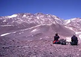
Cerro Walther Penck (also known as Cerro Cazadero or Cerro Tipas) is a massive complex volcano in the Andes, located in northwestern Argentina, Catamarca Province, Tinogasta Department, at the Puna de Atacama. It is just southwest of Ojos del Salado, the highest volcano in the world. Walther Penck itself is perhaps the third highest active volcano in the world.
| Walther Penck | |
|---|---|
| Tipas or Cazadero Grande | |
 Cazadero (or Tipas from the east) | |
| Highest point | |
| Elevation | 6,670 m (21,880 ft) [1][2] |
| Prominence | 651 metres (2,136 ft) |
| Parent peak | Ojos del Salado |
| Coordinates | 27°11′45.96″S 068°33′38.88″W |
| Geography | |
 Walther Penck | |
| Parent range | Puna de Atacama, Andes |
| Geology | |
| Age of rock | Holocene |
| Mountain type | Complex volcano |
| Last eruption | Unknown |
| Climbing | |
| First ascent | 14/12/1970 - Sergio Kunstmann, Pedro Rosende (Chile) and Takaya Takeshita (Japan) |
| Easiest route | Hike, east side from El Arenal |
Vulcanism
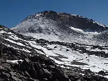
The complex covers a surface area of 25 square kilometres (9.7 sq mi), it consists of stratovolcanoes, lava domes, and lava flows. There are reports of fumarolic activity, and de Silva and Francis (1991) considered that the volcano was last active in the Holocene.[1] The Tipas-Cerro Bayo complex was active 2.9-1.2 million years ago with dacites and rhyolites. Magma composition is typical for Andean stratovolcanoes. Tomographic studies of the underlying crust indicate a pattern of seismic attenuation beneath Tipas.[3]
Elevation
It has an official height of 6658 meters,[4] however, based on the elevation provided by the available Digital elevation models, SRTM (6663m[5]), ASTER (6627m[6]), SRTM filled with ASTER (6663m[6]), TanDEM-X(6699m[7]), and also a handheld GPS survey by Maximo Kausch on 04/2013 (6688 meters),[8] Walther Penck is about 6670 meters above sea level.[8][2]
The height of the nearest key col is 6019 meters.[8] so its prominence is 651 meters. Walther Penck is listed as mountain, based on the Dominance system [9] and its dominance is 9.76%. Its parent peak is Ojos del Salado and the Topographic isolation is 9.8 kilometers.[2] This information was obtained during a research by Suzanne Imber in 2014.[10]
See also
External links
References
- Perucca, Laura P.; Moreiras, Stella M. (2009). "Seismic and Volcanic Hazards in Argentina". Developments in Earth Surface Processes. 13: 267–300. doi:10.1016/S0928-2025(08)10014-1.
- "Walther Penck / Tipas / Cazadero Grande". Andes Specialists. Retrieved 2020-04-12.
- Kay, S. M.; Mpodozis, C.; Gardeweg, M. (7 August 2013). "Magma sources and tectonic setting of Central Andean andesites (25.5-28 S) related to crustal thickening, forearc subduction erosion and delamination". Geological Society, London, Special Publications. 385 (1): 303–334. doi:10.1144/SP385.11.
- "IGN Argentina". IGN Argentina. 14 April 2020. Retrieved 14 April 2020.
- USGS, EROS Archive. "USGS EROS Archive - Digital Elevation - SRTM Coverage Maps". Retrieved 12 April 2020.
- "ASTER GDEM Project". ssl.jspacesystems.or.jp. Retrieved 2020-04-14.
- TanDEM-X, TerraSAR-X. "Copernicus Space Component Data Access". Retrieved 12 April 2020.
- "Andean Mountains - All above 5000m". Andes Specialists. Retrieved 2020-04-12.
- "Dominance - Page 2". www.8000ers.com. Retrieved 2020-04-12.
- ap. "Academic and adventurer describes the incredible task of climbing and cataloguing one of the most remote regions of the South American Andes mountains — University of Leicester". www2.le.ac.uk. Retrieved 2020-04-12.
- Global Volcanism Program: Tipas
- Biggar, John (2020). The Andes: A Guide for Climbers and Skiers (5th ed.). Andes Publishing (Scotland). ISBN 978-0-9536087-6-8.
