Tiverton Township, Coshocton County, Ohio
Tiverton Township is one of the twenty-two townships of Coshocton County, Ohio, United States. As of the 2010 census the population was 449.[3]
Tiverton Township, Coshocton County, Ohio | |
|---|---|
 The Mohican River from the County Road 365 bridge | |
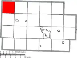 Location of Tiverton Township in Coshocton County | |
| Coordinates: 40°24′18″N 82°9′8″W | |
| Country | United States |
| State | Ohio |
| County | Coshocton |
| Area | |
| • Total | 26.20 sq mi (67.86 km2) |
| • Land | 26.19 sq mi (67.82 km2) |
| • Water | 0.02 sq mi (0.05 km2) |
| Elevation | 1,142 ft (348 m) |
| Population (2010) | |
| • Total | 449 |
| • Density | 17/sq mi (6.6/km2) |
| Time zone | UTC-5 (Eastern (EST)) |
| • Summer (DST) | UTC-4 (EDT) |
| FIPS code | 39-76953[2] |
| GNIS feature ID | 1085927[1] |
Geography
Located in the northwestern corner of the county, it borders the following townships:
- Richland Township, Holmes County - north
- Monroe Township - east
- Jefferson Township - southeast corner
- Newcastle Township - south
- Butler Township, Knox County - southwest corner
- Union Township, Knox County - west
No municipalities are located in Tiverton Township.
Name and history
It is the only Tiverton Township statewide.[4]
Tiverton Township was organized in 1824 by the name of Union Township, but by 1825, the name was changed to Tiverton.[5][6] It was named for Tiverton, Rhode Island, the former hometown of a large share of the first settlers.[7]
Government
The township is governed by a three-member board of trustees, who are elected in November of odd-numbered years to a four-year term beginning on the following January 1. Two are elected in the year after the presidential election and one is elected in the year before it. There is also an elected township fiscal officer,[8] who serves a four-year term beginning on April 1 of the year after the election, which is held in November of the year before the presidential election. Vacancies in the fiscal officership or on the board of trustees are filled by the remaining trustees.
References
- "US Board on Geographic Names". United States Geological Survey. 2007-10-25. Retrieved 2008-01-31.
- "U.S. Census website". United States Census Bureau. Retrieved 2008-01-31.
- "Geographic Identifiers: 2010 Demographic Profile Data (G001): Tiverton township, Coshocton County, Ohio". U.S. Census Bureau, American Factfinder. Archived from the original on February 3, 2015. Retrieved February 2, 2015.
- "Detailed map of Ohio" (PDF). United States Census Bureau. 2000. Retrieved 2007-02-16.
- Kilbourn, John (1833). The Ohio Gazetteer, or, a Topographical Dictionary. Scott and Wright. pp. 442. Retrieved 12 December 2013.
- Hunt, William Ellis (1876). Historical Collections of Coshocton County, Ohio. R. Clarke & Company. pp. 3.
- Graham, Albert Adams (1881). History of Coshocton County, Ohio: Its Past and Present, 1740-1881. A. A. Graham. pp. 594.
- §503.24, §505.01, and §507.01 of the Ohio Revised Code. Accessed 4/30/2009.
External links
Municipalities and communities of Coshocton County, Ohio, United States | ||
|---|---|---|
| City | 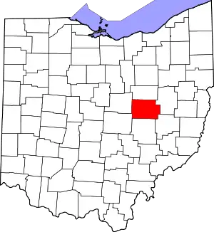 Map of Ohio highlighting Coshocton County | |
| Villages | ||
| Townships | ||
| CDPs | ||
| Unincorporated communities |
| |
| Ghost towns | ||
| Footnotes | ‡This populated place also has portions in an adjacent county or counties | |
| ||