Topla, Črna na Koroškem
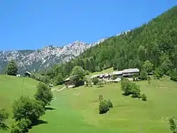
Topla (pronounced [ˈtoːpla]) is a dispersed settlement of isolated farmsteads in a valley with the same name at the foothills of Mount Peca west of Črna na Koroškem in the Carinthia region in northern Slovenia, close to the border with Austria.[2]
Topla | |
|---|---|
 | |
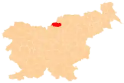
 Topla Location in Slovenia | |
| Coordinates: 46°29′9.18″N 14°45′51.78″E | |
| Country | |
| Traditional region | Carinthia |
| Statistical region | Carinthia |
| Municipality | Črna na Koroškem |
| Area | |
| • Total | 13.43 km2 (5.19 sq mi) |
| Elevation | 1,084.5 m (3,558.1 ft) |
| Population (2002) | |
| • Total | 35 |
| [1] | |
External links
| Settlements | Administrative centre: Črna na Koroškem
|  | ||||
|---|---|---|---|---|---|---|
| Landmarks |
| |||||
This article is issued from Wikipedia. The text is licensed under Creative Commons - Attribution - Sharealike. Additional terms may apply for the media files.