Torbay, New Zealand
Torbay is a suburb of Auckland, New Zealand. It is located on the city's North Shore, and is governed by Auckland Council. The name Torbay comes from the area of the same name in the south east of Devon, England, and from the Tor, a presque-isle at the north end of Waiake Beach that becomes an island at high tide.
Torbay | |
|---|---|
Suburb | |
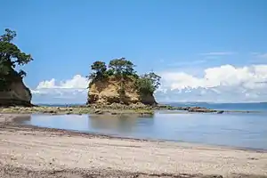 Torbay beach | |
 Torbay | |
| Coordinates: 36°41′44″S 174°45′07″E | |
| Country | New Zealand |
| Local authority | Auckland Council |
| Electoral ward | Albany Ward |
| Population (2018)[1] | |
| • Total | 4,305 |
| Long Bay | (Hauraki Gulf) | |
| Torbay Heights |
|
(Hauraki Gulf) |
| Northcross | Waiake | (Hauraki Gulf) |
Attractions in the area include Long Bay Regional Park which attracts over a million visitors each year. There are also a number of smaller public beaches (Waiake, Torbay beach, Winstone's Cove, Ladder Bay), which are highly accessible and utilised both for swimming, and mooring small yachts.
Demographics
| Year | Pop. | ±% p.a. |
|---|---|---|
| 2006 | 3,942 | — |
| 2013 | 4,065 | +0.44% |
| 2018 | 4,305 | +1.15% |
| Source: [1] | ||

Torbay had a population of 4,305 at the 2018 New Zealand census, an increase of 240 people (5.9%) since the 2013 census, and an increase of 363 people (9.2%) since the 2006 census. There were 1,524 households. There were 2,112 males and 2,193 females, giving a sex ratio of 0.96 males per female. The median age was 41.9 years, with 789 people (18.3%) aged under 15 years, 783 (18.2%) aged 15 to 29, 2,019 (46.9%) aged 30 to 64, and 714 (16.6%) aged 65 or older.
Ethnicities were 86.1% European/Pākehā, 4.9% Māori, 2.6% Pacific peoples, 11.2% Asian, and 2.2% other ethnicities (totals add to more than 100% since people could identify with multiple ethnicities).
The proportion of people born overseas was 43.8%, compared with 27.1% nationally.
Although some people objected to giving their religion, 53.1% had no religion, 36.7% were Christian, and 4.2% had other religions.
Of those at least 15 years old, 1,071 (30.5%) people had a bachelor or higher degree, and 333 (9.5%) people had no formal qualifications. The median income was $38,000. The employment status of those at least 15 was that 1,779 (50.6%) people were employed full-time, 606 (17.2%) were part-time, and 102 (2.9%) were unemployed.[1]
Education
Torbay Primary School is a coeducational contributing primary (years 1-6) school with a roll of 608 students as at March 2020.[2][3] It was established in 1954.[4] In 2019, students of Torbay School taught younger tamariki Te Reo and sign language during Māori Language Week.[5]
Notable residents
- Willis Thomas Goodwin Airey, historian
Notes
- "Statistical area 1 dataset for 2018 Census". Statistics New Zealand. March 2020. Torbay (117200). 2018 Census place summary: Torbay
- "New Zealand Schools Directory". New Zealand Ministry of Education. Retrieved 26 April 2020.
- Education Counts: Torbay School
- "Welcome to Torbay School". Archived from the original on 2 March 2008. Retrieved 7 April 2009.
- KEA Kids News: Tamariki are the te reo teachers at this school
![]() Torbay travel guide from Wikivoyage
Torbay travel guide from Wikivoyage