Town Common, Queensland
Town Common is a coastal suburb in the City of Townsville, Queensland, Australia.[2] It is locally known as "The Common".[3]
| Town Common Townsville, Queensland | |||||||||||||||
|---|---|---|---|---|---|---|---|---|---|---|---|---|---|---|---|
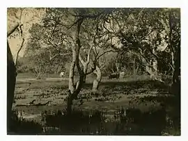 Town Common, 1892 | |||||||||||||||
 Town Common | |||||||||||||||
| Coordinates | 19°13′14″S 146°44′24″E | ||||||||||||||
| Population | 71 (2016 census)[1] | ||||||||||||||
| Postcode(s) | 4810 | ||||||||||||||
| Location | 8.5 km (5 mi) N of Townsville CBD | ||||||||||||||
| LGA(s) | City of Townsville | ||||||||||||||
| State electorate(s) | Townsville | ||||||||||||||
| Federal Division(s) | Herbert | ||||||||||||||
| |||||||||||||||
Geography
Town Common is bounded by the Bohle River to the west, by the Coral Sea to the north-west and east, and Townsville Airport (Garbutt) to the south. Most of the land is flat and at sea level with the exception of Mount Marlow towards the north-east which rises to over 200 metres. The land is mostly undeveloped with much of land contained within the Townsville Town Common Conservation Park. The western part of the suburb is floodplain created by a mangrove-lined network of tributaries of the Bohle River.[4]
The developed land is in the south-east of the locality consisting of the Rowes Bay Golf Club in Emmerson Street (19.2270°S 146.7754°E) and the Garden Settlement Aged Care Village on Cape Pallarenda Road (19.2171°S 146.7760°E).[5] The golf course is irrigated with treated waste water from the Mount St John Wastewater Treatment Plant in Mount St John.[6] The aged care village being the only residential part of the suburb is reflected in the median age for the suburb in the 2011 census being 81 years of age.[7][4][8]
History
The wetlands and lowlands of Town Common the result of sand dune formation and water catchment drainage processes including erosion and sedimentation over thousands of years. Town Common was gazetted in 1869 as common land for the people of Townsville (established in 1864). In 1900 part of the wetlands was established as a sanitary reserve. In 1914 a pasturage reserve was established.[9]
In the 2011 census, Town Common had a population of 163 people.[7]
References
- Australian Bureau of Statistics (27 June 2017). "Town Common (State Suburb)". 2016 Census QuickStats. Retrieved 6 October 2020.

- "Town Common (entry 44647)". Queensland Place Names. Queensland Government. Retrieved 16 April 2016.
- "Revitalising the Townsville Town Common" (PDF). Archived (PDF) from the original on 19 January 2021. Retrieved 17 April 2016.
- "Queensland Globe". State of Queensland. Retrieved 19 January 2021.
- "Rowes Bay Golf Club | Townsville, North Queensland". Rowes Bay Golf Club. Archived from the original on 28 November 2020. Retrieved 19 January 2021.
- "Mount St John Wastewater Treatment Plant" (PDF). Townsville City Council. Archived (PDF) from the original on 5 April 2020. Retrieved 19 January 2021.
- Australian Bureau of Statistics (31 October 2012). "Town Common (SSC)". 2011 Census QuickStats. Retrieved 16 April 2016.
- "Townsville Town Common Regional Park". Queensland Government. Archived from the original on 7 May 2016. Retrieved 17 April 2016.
- "People and History of Town Common". www.creektocoral.org. Archived from the original on 18 April 2017. Retrieved 17 April 2016.
Further reading
- Garnett, Stephen; Cox, Jim, 1939- (1983), Birds of the Townsville Town Common, S.T. Garnett and J.A. Cox, ISBN 978-0-9592593-0-8CS1 maint: multiple names: authors list (link)
- Rowlett, Ursula; Cox, Jim (1982), Water plants of the Townsville Town Common, Printed by T. Willmett
External links
![]() Media related to Town Common, Queensland at Wikimedia Commons
Media related to Town Common, Queensland at Wikimedia Commons