Tréhet
Tréhet is a former commune of the Loir-et-Cher department in central France. On 1 January 2019, it was merged into the new commune Vallée-de-Ronsard.[2]
Tréhet | |
|---|---|
Part of Vallée-de-Ronsard | |
 | |
.svg.png.webp) Coat of arms | |
Location of Tréhet 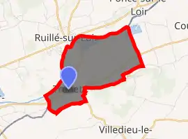
| |
 Tréhet  Tréhet | |
| Coordinates: 47°44′06″N 0°37′21″E | |
| Country | France |
| Region | Centre-Val de Loire |
| Department | Loir-et-Cher |
| Arrondissement | Vendôme |
| Canton | Montoire-sur-le-Loir |
| Commune | Vallée-de-Ronsard |
| Area 1 | 5.65 km2 (2.18 sq mi) |
| Population (2017)[1] | 111 |
| • Density | 20/km2 (51/sq mi) |
| Time zone | UTC+01:00 (CET) |
| • Summer (DST) | UTC+02:00 (CEST) |
| Postal code | 41800 |
| Elevation | 53–110 m (174–361 ft) (avg. 58 m or 190 ft) |
| 1 French Land Register data, which excludes lakes, ponds, glaciers > 1 km2 (0.386 sq mi or 247 acres) and river estuaries. | |
Geography
The commune is situated on the left bank of the Loir close to the Sarthe department communes of La Chartre-sur-le-Loir and Ruillé-sur-Loir and is traversed by the Niclos stream.
Etymology
The name derives from Latin trajectus (crossing).
Population
| Year | Pop. | ±% |
|---|---|---|
| 1793 | 195 | — |
| 1806 | 146 | −25.1% |
| 1821 | 166 | +13.7% |
| 1831 | 215 | +29.5% |
| 1841 | 203 | −5.6% |
| 1851 | 218 | +7.4% |
| 1861 | 204 | −6.4% |
| 1872 | 190 | −6.9% |
| 1881 | 191 | +0.5% |
| 1891 | 179 | −6.3% |
| 1901 | 187 | +4.5% |
| 1911 | 180 | −3.7% |
| 1921 | 154 | −14.4% |
| 1931 | 145 | −5.8% |
| 1946 | 188 | +29.7% |
| 1954 | 170 | −9.6% |
| 1962 | 176 | +3.5% |
| 1968 | 163 | −7.4% |
| 1975 | 168 | +3.1% |
| 1982 | 141 | −16.1% |
| 1990 | 100 | −29.1% |
| 1999 | 123 | +23.0% |
| 2005 | 109 | −11.4% |
| 2915 | 113 | +3.7% |
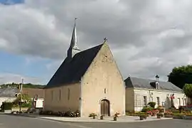
Sights
Its small partly Romanesque church is dedicated to Mary has recently been restored, revealing early wall paintings (the subject is the martyrdom of St. Lawrence).
References
- Téléchargement du fichier d'ensemble des populations légales en 2017, INSEE
- Arrêté préfectoral 29 November 2018 (in French)
| Wikimedia Commons has media related to Tréhet. |
This article is issued from Wikipedia. The text is licensed under Creative Commons - Attribution - Sharealike. Additional terms may apply for the media files.
