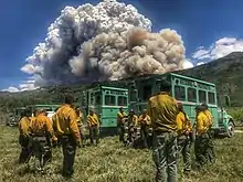
Trail Mountain Fire
The Trail Mountain Fire was a wildfire burning in Manti-La Sal National Forest fifteen miles northwest of Orangeville, Utah in the United States. The fire was started on June 6, 2018, after the Trail Mountain Prescribed Fire escaped due to high winds. As of June 27, the fire burnt 17,767 acres (72 km2) and was 80 percent contained.
| Trail Mountain Fire | |
|---|---|
 | |
| Location | Manti-La Sal National Forest, Utah, United States |
| Coordinates | 39.358°N 111.216°W |
| Statistics[1] | |
| Date(s) | June 6, 2018 – |
| Burned area | 17,767 acres (72 km2) |
| Cause | Escaped Prescribed Fire Due To High Winds |
| Land use | National forest |
| Buildings destroyed | 1 |
| Map | |
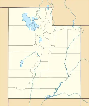 Location of fire in Utah. | |
Incidents
The Trail Mountain Fire began when the Trail Mountain Prescribed Burn escaped across Cottonwood Canyon Road to East Mountain on June 6, 2018, burning 300 acres (1 km2). By June 10, high wind gusts of 55 miles per hour caused the fire to grow into Meetinghouse Canyon. The heavy winds caused all air support fighting the fire to be grounded. One cabin in the Whetstone Creek area was burned. A temporary flight restriction was put in place for the area. Indian Creek Campground was closed.[2]
By June 12, heavy smoked had permeated the area. The fire had expanded north into Deer Creek Canyon, Rilda Canyon and the plateaus above Mill Fork Canyon, which all feed into Huntington Canyon.[3] The next day, Highway 31 was closed and areas of Huntington Canyon were closed and select campgrounds were evacuated.[4] On June 14, the highway and Huntington Canyon reopened.[5] However, the next day, June 15, Highway 31 was closed once again due to fire activity and heavy use of the highway by fire crews. By the end of the day, the fire had grown 3,000 acres (12 km2) to 13,710 acres (55 km2) and was ten percent contained.[6][7]
Officials re-opened Highway 31 through Huntington Canyon on June 16. The fire had minimal activity due to high humidity and cloud cover.[8] The northern part of the fire remained uncontained while crews focused on scattering cut vegetation, stabilizing soils, installing water bars to manage water and sediment, and removing hazardous, fire-weakened trees along roads in contained areas.[9]
By June 22, Red Flag Warnings impacted the fire, pushing it into Crandall Canyon and keeping it active in Little Bear Canyon. The fire did not impact the Crandall Canyon Mine and memorial.[10]
As of June 27, the fire has burned 17,767 acres (72 km2) and is 80 percent contained. It is fueled by mixed conifer and dead and down timber.[2]
Closures
Information may be outdated as of February 20, 2019.
Indian Creek Campground is closed. Temporary closure of Forest Road 0040 (Cottonwood Canyon) has been implemented, as well as the closure of Forest Roads 0034, 2302, 2181, 2180, and 2182. Forest Trail 0051, the Trail Mountain CCC Trail, is also temporarily closed.[2]
References
- "Trail Mountain Fire". InciWeb. U.S. Forest Service California. Retrieved 26 June 2018.
- "Trail Mountain Fire expands in high winds - InciWeb the Incident Information System". InciWeb. Retrieved 27 June 2018.
- "Trail Mountain Fire Continues to Advance - InciWeb the Incident Information System". inciweb.nwcg.gov. Retrieved 27 June 2018.
- "Trail Mountain Fire Update - InciWeb the Incident Information System". InciWeb. Retrieved 27 June 2018.
- "Trail Mountain Fire Evening Update 6.14 - InciWeb the Incident Information System". InciWeb. Retrieved 27 June 2018.
- "Trail Mountain Fire Evening Update 6.15 - InciWeb the Incident Information System". InciWeb. Retrieved 27 June 2018.
- "Trail Mountain Fire Morning Update 6.16 - InciWeb the Incident Information System". inciweb.nwcg.gov. Retrieved 27 June 2018.
- "Trail Mountain Fire Morning Update 6.17 - InciWeb the Incident Information System". InciWeb. Retrieved 27 June 2018.
- "Trail Mountain Fire Morning Update 6.18 - InciWeb the Incident Information System". InciWeb. Retrieved 27 June 2018.
- "Trail Mountain Fire Morning Update 6.22 - InciWeb the Incident Information System". InciWeb. Retrieved 27 June 2018.
![]() This article incorporates public domain material from websites or documents of the United States Department of Agriculture.
This article incorporates public domain material from websites or documents of the United States Department of Agriculture.