Trans-Arabian Pipeline
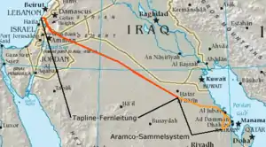
The Trans-Arabian Pipeline (Tapline), was an oil pipeline from Qaisumah in Saudi Arabia to Sidon in Lebanon. In its heyday, it was an important factor in the global trade of petroleum—helping with the economic development of Lebanon—as well as American and Middle Eastern political relations.
History
Construction of the Trans-Arabian Pipeline began in 1947 and was mainly managed by the American company Bechtel. Originally the Tapline was intended to terminate in Haifa which was then in the British Mandate of Palestine, but due to the establishment of the state of Israel, an alternative route through Syria (Golan Heights) and Lebanon was selected with an export terminal in Sidon.
The Syrian government initially opposed the plan. Four days after a military coup that overthrew democratic rule the deal was ratified. The coup’s leader Husni al-Za'im was overthrown and murdered 136 days later, but the project was unstoppable.[1]
Since the 1967 Six-Day War, the section of the pipeline which runs through the Golan Heights came under Israeli control, though the Israelis permitted the pipeline's operation to continue. After years of constant arguing between Saudi Arabia and Syria and Lebanon over transit fees, the emergence of oil supertankers, and pipeline breakdowns, the section of the line beyond Jordan ceased operation in 1976. The remainder of the line between Saudi Arabia and Jordan continued to transport modest amounts of petroleum until 1990 when the Saudis cut off the pipeline in response to Jordan's support of Iraq during the first Gulf War. Today, the entire line is unfit for oil transport.[2]
Technical features
The Trans-Arabian Pipeline was 1,214 kilometres (754 mi) long with a diameter of 30 inches (760 mm). When constructed, it was the world's largest oil pipeline system. The initial capacity of the pipeline was 300,000 barrels per day (48,000 m3/d) (bpd), eventually rising to a maximum capacity of about 500,000 bbl/d (79,000 m3/d) with the addition of several more pumping stations. While the pipeline was considered groundbreaking and innovative at the time it was built, were it still operational to this day it would be considered somewhat outdated — nowadays, most modern long-distance pipelines constructed beginning in the second half of the twentieth century have been built to a diameter of 42 inches (1,070 mm) or 48 inches (1,220 mm) and thus able to transport considerably more crude oil per day than Tapline did in its heyday. The pipeline was supplied from the oil fields near Abqaiq.
The Tapline corridor has remained a potential export route for Persian Gulf oil exports to Europe and the United States. At least one analysis has indicated that the transportation cost of exporting oil via the Tapline through Haifa to Europe would cost as much as 40 percent less than shipping by tanker through the Suez Canal. In early 2005, rehabilitation of the Tapline at an estimated cost of US$100 to US$300 million was one of the strategic options being considered by the Jordanian government to meet oil needs.
Pipeline company
The pipeline was built and operated by the Trans-Arabian Pipeline Company. It was founded as a joint venture between Standard Oil of New Jersey (now ExxonMobil), Standard Oil of California (Chevron), the Texas Company (better known as Texaco, now a part of Chevron), and Socony-Vacuum Oil Company (now part of ExxonMobil), however, it eventually became a fully owned subsidiary of Aramco. The company continued operating with no oil being transported until the end of 2002, when Aramco fully closed the Tapline subsidiary.
Tapline Road
For the Israeli Road see: Petroleum Road
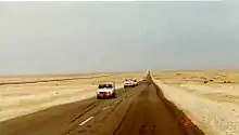
Tapline Road is the major east-west two lane highway running the length of Saudi Arabia from Turaif, Jordan, in the west, to Qaisumah, Saudi Arabia on the Persian Gulf, in the east. It was so named because it parallels the Trans-Arabian Pipeline. The Tapline Road was, on average, only 50 kilometers from Saudi Arabia's northern border[3] for a distance of 514 miles or 827.2 kilometers.[4] Initially only a dirt and gravel road used by ARAMCO and the Saudi Government it was widened and paved by 1965 due to use by civilian and commercial traffic. It was incorporated into the Saudi Highway system in 1965[5] when it was extended into Damman. Since Tapline Road is a semi-private road mostly maintained by Aramco, and has been assigned the number 6335 until it meets Highway 85 (King Fahd Road) where-after it is maintained by the Saudi Arabian Ministry of Transport, it remains Highway 85 until near the Jordanian border where it meets Highway 65, in Qurayyat and crosses the Jordanian Border at Umari and becomes Jordanian Highway 30.[6] Tapline Road/Highway 85 is deemed one of the most dangerous roads in the world due to its straightness.[7][8]
References
- Barr, James (2018). Lords of the Desert: Britain's Struggle with America to Dominate the Middle East. Simon & schuster. p. 103. ISBN 9781471139796.
- "Eastern Mediterranean. Oil". Energy Information Agency. October 2006. Archived from the original on 2007-11-05. Retrieved 2008-01-03. Cite journal requires
|journal=(help) - https://almashriq.hiof.no/lebanon/300/380/388/tapline/general/war-diary.html
- https://archive.aramcoworld.com/issue/196702/desert.road.htm
- https://archive.aramcoworld.com/issue/196702/desert.road.htm
- https://www.google.com/maps/place/Tapline+Road+Saudi+Arabia/@27.262251,48.9919235,598m/data=!3m1!1e3!4m5!3m4!1s0x3e35a96a8e9da6f1:0x8a1e30a99e0925ff!8m2!3d26.8995635!4d49.4584457
- https://www.dangerousroads.org/around-the-world/our-lists/3759-the-10-longest-straight-roads-in-the-world.html
- https://drivetribe.com/p/top-5-longest-straight-roads-QYpO9cfxSOa5G6870tSkSA?iid=DJkhJD3aQfyc0IOIwtVfoA
External links
| Wikimedia Commons has media related to Trans-Arabian Pipeline. |