Trappe, Maryland
Trappe is a town in Talbot County, Maryland, United States. The population was 1,077 at the 2010 census.
Trappe, Maryland | |
|---|---|
| Motto(s): "19th Century Charm - 21st Century Progress"[1] | |
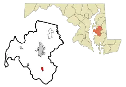 Location of Trappe, Maryland | |
 Trappe Location within the U.S. state of Maryland  Trappe Trappe (the United States) | |
| Coordinates: 38°39′36″N 76°3′29″W | |
| Country | |
| State | |
| County | |
| Incorporated | 1827[2] |
| Area | |
| • Total | 2.67 sq mi (6.91 km2) |
| • Land | 2.67 sq mi (6.91 km2) |
| • Water | 0.00 sq mi (0.00 km2) |
| Elevation | 52 ft (16 m) |
| Population | |
| • Total | 1,077 |
| • Estimate (2019)[5] | 1,000 |
| • Density | 374.95/sq mi (144.78/km2) |
| Time zone | UTC-5 (Eastern (EST)) |
| • Summer (DST) | UTC-4 (EDT) |
| ZIP code | 21673 |
| Area code(s) | 410 |
| FIPS code | 24-78575 |
| GNIS feature ID | 0591425 |
| Website | http://trappemd.net/ |
History
Trappe was incorporated in 1827.[2] It may have been named for either wolf traps or a Trappist monastery.[6]
Compton and The Wilderness are listed on the National Register of Historic Places.[7]
A Blessing Box was installed at the Trappe Volunteer Firehouse in 2019 by Josh Cherry.[8]
Geography
Trappe is located at 38°39′36″N 76°3′29″W (38.659870, -76.058053).[9]
According to the United States Census Bureau, the town has a total area of 2.78 square miles (7.20 km2), all land.[10]
Demographics
| Historical population | |||
|---|---|---|---|
| Census | Pop. | %± | |
| 1860 | 305 | — | |
| 1870 | 272 | −10.8% | |
| 1880 | 301 | 10.7% | |
| 1890 | 261 | −13.3% | |
| 1900 | 279 | 6.9% | |
| 1910 | 273 | −2.2% | |
| 1920 | 236 | −13.6% | |
| 1930 | 226 | −4.2% | |
| 1940 | 296 | 31.0% | |
| 1950 | 325 | 9.8% | |
| 1960 | 358 | 10.2% | |
| 1970 | 426 | 19.0% | |
| 1980 | 739 | 73.5% | |
| 1990 | 974 | 31.8% | |
| 2000 | 1,146 | 17.7% | |
| 2010 | 1,077 | −6.0% | |
| 2019 (est.) | 1,000 | [5] | −7.1% |
| U.S. Decennial Census[11] | |||
2010 census
As of the census[4] of 2010, there were 1,077 people, 434 households, and 299 families residing in the town. The population density was 387.4 inhabitants per square mile (149.6/km2). There were 491 housing units at an average density of 176.6 per square mile (68.2/km2). The racial makeup of the town was 65.3% White, 28.1% African American, 0.6% Native American, 1.3% Asian, 2.4% from other races, and 2.2% from two or more races. Hispanic or Latino of any race were 6.3% of the population.
There were 434 households, of which 32.0% had children under the age of 18 living with them, 48.4% were married couples living together, 14.5% had a female householder with no husband present, 6.0% had a male householder with no wife present, and 31.1% were non-families. 23.7% of all households were made up of individuals, and 8.5% had someone living alone who was 65 years of age or older. The average household size was 2.48 and the average family size was 2.91.
The median age in the town was 39.5 years. 22.5% of residents were under the age of 18; 9.2% were between the ages of 18 and 24; 25.5% were from 25 to 44; 30% were from 45 to 64; and 12.6% were 65 years of age or older. The gender makeup of the town was 48.0% male and 52.0% female.
2000 census
As of the census[12] of 2000, there were 1,146 people, 425 households, and 328 families residing in the town. The population density was 1,387.9 people per square mile (533.1/km2). There were 450 housing units at an average density of 545.0 per square mile (209.3/km2). The racial makeup of the town was 72.34% White, 23.39% African American, 0.44% Native American, 0.70% Asian, 1.05% from other races, and 2.09% from two or more races. Hispanic or Latino of any race were 2.62% of the population.
There were 425 households, out of which 41.4% had children under the age of 18 living with them, 57.2% were married couples living together, 15.1% had a female householder with no husband present, and 22.6% were non-families. 16.2% of all households were made up of individuals, and 7.1% had someone living alone who was 65 years of age or older. The average household size was 2.70 and the average family size was 2.95.
In the town, the population was spread out, with 28.8% under the age of 18, 6.7% from 18 to 24, 32.5% from 25 to 44, 22.0% from 45 to 64, and 10.0% who were 65 years of age or older. The median age was 34 years. For every 100 females, there were 92.0 males. For every 100 females age 18 and over, there were 84.2 males.
The median income for a household in the town was $40,625, and the median income for a family was $42,188. Males had a median income of $30,398 versus $26,302 for females. The per capita income for the town was $17,451. About 9.6% of families and 9.7% of the population were below the poverty line, including 10.9% of those under age 18 and 7.9% of those age 65 or over.
Notable people
- Frank "Home Run" Baker, Hall of Fame third baseman in Major League Baseball; born in Trappe.[13]
- John Dickinson, Founding Father; born in Trappe.[14]
- Brigadier General John S. D. Eisenhower, US Army Reserve (Ret), former US Ambassador to Belgium (1969–71), career military officer and military historian, lived in Trappe after moving from Kimberton, Pennsylvania until his death on December 21, 2013.
- Robert Mitchum; Mitchum and his family lived in Trappe from 1959–1965.
Notable places
2007 plane crash
On April 4, 2007, a small plane crashed into a field in Trappe, killing the private pilot and his two passengers. The aircraft had left White Plains, New York and was heading for North Carolina, when it encountered an area of intense thunderstorm activity. The left wing departed the ship while deviating around the area of bad weather. The NTSB determined the cause of the crash was "The pilot's improper decision to fly into an area of thunderstorms, which resulted in a loss of aircraft control and subsequent in-flight breakup. Contributing to the accident was the thunderstorm."
References
- "Town of Trappe Maryland". Town of Trappe Maryland. Retrieved September 26, 2012.
- "Trappe, Maryland". City-Data.com. Retrieved September 26, 2012.
- "2019 U.S. Gazetteer Files". United States Census Bureau. Retrieved July 25, 2020.
- "U.S. Census website". United States Census Bureau. Retrieved 2013-01-25.
- "Population and Housing Unit Estimates". United States Census Bureau. May 24, 2020. Retrieved May 27, 2020.
- "Profile for Trappe, Maryland, MD". ePodunk. Retrieved September 26, 2012.
- "National Register Information System". National Register of Historic Places. National Park Service. July 9, 2010.
- Douglass, Cate (2019-12-04). "Talbot County Teen Creates The Blessing Box to Help Others in Need". WBOC. Retrieved 2019-12-28.
- "US Gazetteer files: 2010, 2000, and 1990". United States Census Bureau. 2011-02-12. Retrieved 2011-04-23.
- "US Gazetteer files 2010". United States Census Bureau. Archived from the original on 2012-01-25. Retrieved 2013-01-25.
- "Census of Population and Housing". Census.gov. Retrieved June 4, 2015.
- "U.S. Census website". United States Census Bureau. Retrieved 2008-01-31.
- "Baker, Frank". National Baseball Hall of Fame and Museum. Retrieved September 26, 2012.
- "DICKINSON, John, (1732 - 1808)". Biographical Directory of the United States Congress. Retrieved September 26, 2012.
External links
Municipalities and communities of Talbot County, Maryland, United States | ||
|---|---|---|
| Towns | 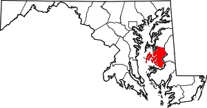 | |
| CDPs | ||
| Other communities | ||
| Footnotes | ‡This populated place also has portions in an adjacent county or counties | |
| ||