Trento-Mattarello Airport
Trento-Mattarello Airport (Italian: Aeroporto di Trento-Mattarello; IATA: LIDT), also known as Aeroporto G.Caproni, is an airfield located at Trentino, 3.4 NM (6.3 km; 3.9 mi) south [1] of Trento, Italy.
Trento-Mattarello (G.Caproni) Airport Aeroporto di Trento-Mattarello | |||||||||||
|---|---|---|---|---|---|---|---|---|---|---|---|
 | |||||||||||
| Summary | |||||||||||
| Airport type | Private | ||||||||||
| Serves | Trento | ||||||||||
| Location | Trento, Italy | ||||||||||
| Elevation AMSL | 610 ft / 186 m | ||||||||||
| Coordinates | 46°01′24″N 011°07′30″E | ||||||||||
| Website | |||||||||||
| Map | |||||||||||
 LIDT Location in Italy | |||||||||||
| Runways | |||||||||||
| |||||||||||
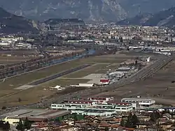
The airport is at an elevation of 610 feet (186 m) above mean sea level. It has one runway designated 18/36 with an asphalt surface measuring 1,130 by 30 metres (3,707 ft × 98 ft).[1]
Operations
The Airport is home to numerous flying schools and clubs.[4] Additionally the Protezione Civile has a fleet of Helicopters stationed at the airport.
Transportation
Bus
There is no direct bus service to the airport however within a 20 minute walk from the Airport Terminal (1.5km) Parcheggio Via Lidorno offers a bus service into town[5]
References
- "Data" (PDF). www.aeroportocaproni.com. Retrieved 2020-06-17.
- "FLY BIKE HOTEL $68 ($̶7̶5̶) - Prices & Reviews - Trento, Italy". Tripadvisor.
- "Servizi". www.aeroportocaproni.com.
- "Aziende in aeroporto". www.aeroportocaproni.com.
- "Navetta parcheggi". www.trentinotrasporti.it.
External links
This article is issued from Wikipedia. The text is licensed under Creative Commons - Attribution - Sharealike. Additional terms may apply for the media files.