Tri-State Peak
Tri-State Peak is a mountain located in the Cumberland Gap National Historical Park, near the "saddle" of the gap. It gets its name from being on the tripoint of the states of Kentucky, Tennessee, and Virginia.
| Tri-State Peak | |
|---|---|
 The summit of Tri-State Peak | |
| Highest point | |
| Elevation | 1,990 ft (610 m) [1] |
| Coordinates | 36°36′03″N 83°40′28″W |
| Geography | |
| Location | Cumberland Gap National Historical Park, Bell County, Kentucky, Claiborne County, Tennessee, and Lee County, Virginia, United States |
| Parent range | Cumberland Mountains |
| Climbing | |
| Easiest route | Tri-State Peak Trail |
The elevation at the tri-state marker is 1,990 feet (607 m).[2] The marker can be accessed via the "tri-state peak trail," (via connections with the Gap trail and the Object Lesson Road trail) and is about 1.2 miles from the park's visitor's center.[3]
The site also includes a marker denoting the location as being on the "Royal Colonial Boundary of 1665," which was marked by the American Society of Civil Engineers.
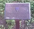 Royal Colonial Boundary of 1665 plaque
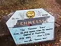 Marker for Tennessee at Tri-State Peak
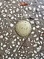 Marker for the KY-TN-VA tripoint
See also
References
- United States Geological Survey (2016). Middlesboro South (PDF) (Topographic map). 1:24,000. 7.5 Minute Series. Reston, VA: United States Geological Survey. Retrieved October 21, 2020.
- http://www.nps.gov/archive/cuga/tristate.htm
- http://www.nps.gov/archive/cuga/trails.htm


This article is issued from Wikipedia. The text is licensed under Creative Commons - Attribution - Sharealike. Additional terms may apply for the media files.