Troy Township, Athens County, Ohio
Troy Township is one of the fourteen townships of Athens County, Ohio, United States. The 2010 census found 2,617 people in the township,[3] 2,121 of whom lived in the unincorporated portions of the township.
Troy Township, Athens County, Ohio | |
|---|---|
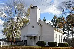 Methodist church at Torch | |
 Location of Troy Township in Athens County | |
| Coordinates: 39°13′22″N 81°47′13″W | |
| Country | United States |
| State | Ohio |
| County | Athens |
| Area | |
| • Total | 36.9 sq mi (95.6 km2) |
| • Land | 36.2 sq mi (93.7 km2) |
| • Water | 0.7 sq mi (1.8 km2) |
| Elevation | 768 ft (234 m) |
| Population (2010) | |
| • Total | 2,617 |
| • Density | 72/sq mi (27.9/km2) |
| Time zone | UTC-5 (Eastern (EST)) |
| • Summer (DST) | UTC-4 (EDT) |
| FIPS code | 39-77546[2] |
| GNIS feature ID | 1085759[1] |
Geography
Located in the southeastern corner of the county along the Ohio River, it borders the following townships:
- Decatur Township, Washington County - north
- Belpre Township, Washington County - northeast
- Olive Township, Meigs County - south
- Orange Township, Meigs County - southwest corner
- Carthage Township - west
- Rome Township - northwest
Wood County, West Virginia lies across the Ohio River to the southeast.
The village of Coolville is located in central Troy Township, and the unincorporated community of Hockingport lies along the Ohio River shoreline.
Name and history
It is one of seven Troy Townships statewide.[4]
In 1833, Troy Township contained several stores and mills.[5]
Government
The township is governed by a three-member board of trustees, who are elected in November of odd-numbered years to a four-year term beginning on the following January 1. Two are elected in the year after the presidential election and one is elected in the year before it. There is also an elected township fiscal officer,[6] who serves a four-year term beginning on April 1 of the year after the election, which is held in November of the year before the presidential election. Vacancies in the fiscal officership or on the board of trustees are filled by the remaining trustees.
References
- "US Board on Geographic Names". United States Geological Survey. 2007-10-25. Retrieved 2008-01-31.
- "U.S. Census website". United States Census Bureau. Retrieved 2008-01-31.
- "Geographic Identifiers: 2010 Demographic Profile Data (G001): Troy township, Athens County, Ohio". U.S. Census Bureau, American Factfinder. Archived from the original on February 12, 2020. Retrieved July 10, 2013.
- "Detailed map of Ohio" (PDF). United States Census Bureau. 2000. Retrieved 2007-02-16.
- Kilbourn, John (1833). The Ohio Gazetteer, or, a Topographical Dictionary. Scott and Wright. pp. 443. Retrieved 12 December 2013.
- §503.24, §505.01, and §507.01 of the Ohio Revised Code. Accessed 4/30/2009.
External links
Municipalities and communities of Athens County, Ohio, United States | ||
|---|---|---|
| Cities | 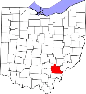 Map of Ohio highlighting Athens County | |
| Villages | ||
| Townships | ||
| CDPs | ||
| Unincorporated communities | ||
| Footnotes | ‡This populated place also has portions in an adjacent county or counties | |
| ||