Tswanaland
Tswanaland was a bantustan in South West Africa (present-day Namibia), in the far central eastern area of the territory around the village of Aminuis. It was intended by the apartheid government to be a self-governing homeland for the Tswana people. Unlike all other homelands, it was never implemented that way. The Ovaherero were allowed to stay in the area, and the Tswana remained a minority.[1] Tswanaland nevertheless got an ethnic Tswana, Constance Kgosiemang, as political leader between 1980 and 1989.[2]
Tswanaland | |||||||||
|---|---|---|---|---|---|---|---|---|---|
| 1980–1989 | |||||||||
.svg.png.webp) Flag | |||||||||
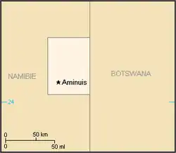 Map of the bantustan. | |||||||||
| Status | Bantustan | ||||||||
| Capital | Aminuis | ||||||||
| History | |||||||||
• Established | 1980 | ||||||||
• Re-integrated into Namibia | May 1989 | ||||||||
| Currency | South African rand | ||||||||
| |||||||||
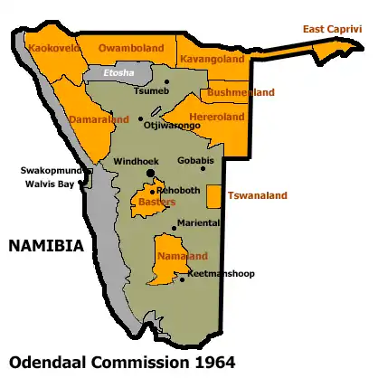
Allocation of Land to bantustans according to the Odendaal Plan. Tswanaland is the rectangle in eastern central South West Africa
Tswanaland and all other homelands in South West Africa were abolished in May 1989 at the start of the transition to independence.
.jpg.webp)
Aroams Oos in Tswanaland (2017) 23.053451°S 19.644827°E
See also
References
- Dierks, Klaus. "Biographies of Namibian Personalities, Entry for Clemens Kapuuo". klausdierks.com. Retrieved 14 May 2012.
- Dierks, Klaus. "Biographies of Namibian Personalities, Entry for Constance Kgosimang". klausdierks.com. Retrieved 14 May 2012.
| |||||||||||||||||||||||||||||||||||||||||||||||||||||||||||||||||||||||||||||||||||||||||||||||||||||||||||
This article is issued from Wikipedia. The text is licensed under Creative Commons - Attribution - Sharealike. Additional terms may apply for the media files.
