Tunnels of Claudius
The Tunnels of Claudius (Italian: Cunicoli di Claudio) are a hydraulic work made up of a long underground canal, six inclined service tunnels and thirty-two wells, which Emperor Claudius had built between 41 and 52 AD[1][2] to control the variable levels of the Fucine Lake in Abruzzo, thus protecting riparian villages from floods and reclaiming the Fucine lands making them cultivable. Thanks to them, the lake waters flowed out through the belly of Mount Salviano from the Avezzano side along the almost 6-kilometre-long (3.7 mi) tunnel[3] until they flowed into the Liri River on the opposite side of the mountain, under the old town of Capistrello. The underground canal represents the longest tunnel ever built since ancient times until the inauguration of the Fréjus Rail Tunnel occurring in 1871.[4]
Cunicoli di Claudio | |
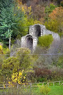 Entrances to the major tunnel | |
 Shown within Italy | |
| Location | Avezzano, Capistrello, Province of L'Aquila, Abruzzo, Italy |
|---|---|
| Region | Marsica |
| Coordinates | 41°59′18.7″N 13°26′0.2″E |
| Type | Cistern, thermae, port |
| History | |
| Builder | Claudius |
| Cultures | Ancient Rome |
| Site notes | |
| Ownership | public |
| Management | Soprintendenza per i Beni Archeologici dell'Abruzzo |
| Public access | Yes |
| Website | cultura.regione.abruzzo.it (in Italian) |
With the fall the Roman Empire, and during the Barbarian invasions, the main canal, not maintained anymore, became definitively clogged. Centuries later, starting from 1854, Alessandro Torlonia built the new canal, more than 6 kilometres (3.7 mi) long, mostly following Claudius' immissary and emissary.[3] The new hydraulic work, starting from a monumental inlet (Italian: incile) situated near the lake south of Avezzano, known as Incile del Fucino (Fucine Inlet), allowed the definitive drainage of the lake.[5][6]
In 1902 the hydraulic work was included among Italian national monuments;[7] the tunnel area represents a site of archaeological and speological interest, provided with a park inaugurated in 1977 with the purpose of protecting and exploiting the whole work.[5][8]
History
Origin of the plan
Before the Claudian works it was Julius Caesar, pressed by Marsi, the local inhabitants, to see to the reclamation plan of the Fucine plateau, in Abruzzo. The initial purpose was to control the unstable level of the lake, which very often flooded riparian villages because of the frequent cloggings of the only natural swallow-hole situated at Petogna near Luco dei Marsi, while in summer, above all because of the receding waters, the lands surrounding the inhabited areas often became marshy causing serious sanitary problems to the population.[9] According to Suetonius, beside the main purpose there was the ambitious aim of tracing a road connecting the Tiber with the Adriatic Sea through the Apennine Mountains[10] Caesar was not able to provide for the work since he was killed before carrying out his plan.[5]
Construction
A first planning hypothesis provided the digging of a canal that would let the lake waters flow out through the low Cesolino hill flowing them into the Salto River. This easily feasible plan was discarded quickly, because the considerable amount of water, flowing first into the Velino River, then into the Nera River, and finally into the Tiber, would represent a flood threat for Rome. A second but harder plan provided instead to let the lake waters flow into the Liri River along a tunnel dug in Mount Salviano.[5]
In 41 AD[2] it was Emperor Claudius who resumed the ambitious plan and, thanks to a substantial public financing, entrusted a Roman enterprise with the works. The work, considered to be among the grandest hydraulic enterprises of the antiquity, was to regulate the flow of the Fucine Lake, feared by local populations due to the violence of its waters. Along its banks, about 30,000 men, among slaves and workmen, strove intent on the manual digging of the swallow-hole. Eleven years later, in 52 AD, the work was brought to an end.[11] First collateral tunnels were constructed, connected to each other by means of numerous inclined shafts (or wells), which served to prepare the main digging, having completed which, waters drained towards the Liri River. However, there were a lot of unexpected inconveniences and difficulties during the work construction, including several landslides occurring in the most vulnerable and sandiest sections of the belly or the mountain and in the area of the dam, that is the lock made between the Roman basins for the water storage and the mouth of the emissary near the Fucine inlet.[12]
When the works were concluded Claudius, before the opening of the locks, celebrated the work by organizing a naumachia, a naval battle on the lake, with the presence of his wife Agrippina and the young Nero.[6][13] Later on with Trajan, between 98 and 117 AD, and with Hadrian, between 117 and 138 AD, there were maintenance works, which became necessary right from the inauguration due to the configuration of the carved rock, with a great economic and even human cost. Thanks to this work the lake basin shrank by about 6,000 hectares (15,000 acres) warding off the flood danger. The economy of Marsica and especially of the municipalities of Alba Fucens, Lucus Angitiae and Marruvium became thriving, and the surrounding mountainous areas were chosen as holiday resorts.[14]
Decadence
With the fall of the Roman Empire and the Barbarian invasions which also marked Marsica history, maintenance inevitably failed, so much so that, most probably also because of a serious earthquake occurring in 508 AD,[15] canals became clogged with the consequence of the return of the Fucine Lake to the previous levels.[16] In the subsequent centuries Frederick II of Hohenstaufen (13th century) and Ferdinand I of the Two Sicilies (1790) tried to restore the water drainage into the Roman emissary, failing in their purpose due to the scarsity of funds and the complexity of the project.[17]
New hydraulic works
.jpg.webp)
.jpg.webp)
From 1826, about 18 centuries after the first Claudian drainage, new attempts to partially recover the function of the emissary were carried out by Cavaliere Luigi Giura and Commendatore Carlo Afan de Rivera.[18]
Afan de Rivera was given the task by King Francis I of providing for the new restoration plan of the emissary of Claudius. But it was with the intervention of Roman banker Alessandro Torlonia that on 10 July 1854 the Claudian plan was resumed with the technical assistance of Swiss engineer Franz Mayor de Montricher. The work was concluded in 1870 by two engineers, Swiss site engineer Enrico Samuele Bermont and French deputy site engineer Alessandro Brisse, assisted by agent Léon De Rotrou.[19] In 1873 the gradual drainage of the Fucine Lake began, while the reclamation operations of the territory were brought to an end between 1875 and 1876.[20]
Thus, following considerable economic efforts the Abruzzese lake was completely and definitively drained, which was the third in Italy as to the extent with about 16,000 hectares (40,000 acres).[21][22][23] Workers and technicians, among the best and most qualified of the time, were employed for decades, who restored the original emissary enlarging its section. The waters of the Fucine flowed out slowly into the Liri River from the exit of the tunnel under the old town of Capistrello.[24] Other canals and wells were added to the old tunnels and those from the Roman age were enlarged.[19] The purpose of the rock-carved tunnels with an inclined course was that of allowing air to arrive into the Mount Salviano tunnel and workers, means and dug materials to pass through.[25]
On 1 October 1878 the lake was officially declared drained.[26] Thus the Fucine plain, having been reclaimed and quickly supplied with several facilities,[27] became a fertile land, ideal for farming productions, especially cereals, vegetables and sugar beets, the latter being processed in the Avezzano sugar mill.[28][29][30] And so it was that Fucine fishers became farmers.[20]
A second emissary was made built by the Torlonia in the first half of the 20th century, with the purpose of compensating for the functions of the main tunnels in case of extraordinary repairs. It starts from the intersection point of the Roman emissary with the outer drainage next to one of the water storage basins of the Incile del Fucino southwards, ending up in Canistro next to one of the hydroelectric power plants built by the Torlonia with the aim of generating power for the operation of the Avezzano paper and sugar mill.[31]
Perspectives
In June 1977, with the aim of protecting and exploiting the work, the Archaeological Park of Claudius was established, comprised between the entrances to the tunnels and the Fucine Inlet.[8][32]
The work was inserted among the Luoghi del Cuore ("Places of the Heart") for the year 2016 by FAI.[33]
In 2017 funds were allocated for the park exploitation by the Chamber of Commerce of L'Aquila, the municipality of Avezzano and the GAL Terre Aquilane ("Aquilan Lands").[34][35]
Architecture
.jpg.webp)
Emissary
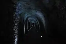
The total length of the underground emissary is over 6 km (3.7 mi). It features a variable section 5 to 10 m2 (54 to 108 sq ft) wide and an average flow rate of 9.09 m3/s (321 cu ft/s)[2] with a drop of 8.44 m (27.7 ft) and an average gradient of 1.50 m/km (7.9 ft/mi) in the stretch comprised between the entrance to the Fucine Inlet and the exit of Capistrello.[36][37] The entrance lies near the "emissary head" of the inlet at Borgo Incile south of Avezzano, next to the intersection with the outer drainage canal crossing the plateau longitudinally as far as the Bacinetto ("Little Basin"), a reservoir made built by Alessandro Torlonia to be used in case of extraordinary repairs or water needs. It is a depressed area of the plain whose elevation stands lower; it is located between the central pumping station of Borgo Ottomila (Celano) and the territories of Ortucchio, San Benedetto dei Marsi and Venere dei Marsi.[13][38]
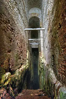
The section of the Torlonia emissary allows in certain points to observe the original one from the Roman age in both the entrance area to the Inlet and the exit that is situated on the opposite side of the mountain, under the old town of Capistrello, at Pisciacotta. In fact, in some parts it preserves the Roman age walls built in opus reticulatum. In order to simplify the drilling and extraction work of the material, 32 vertical wells and 6 inclined tunnels were also dug, of which in particular the impressive rests located on the eastern side of Mount Salviano are visible.
Fucine Inlet
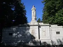
The emissary head of Borgo Incile is dominated by the large statue of the Immaculate Conception of the Blessed Virgin Mary rising above the three-arched bridge of the sluice gates. The work was constructed by architect Carlo Nicola Carnevali in 1876.[13] The structure features two water storage basins, one with a trapezoidal shape and the other hexagonal, and three gates (or locks). The first one separates the major hexagonal basin from the forebasin through a gorge.[39]
The tunnels
- Major Tunnel (Italian: Cunicolo Maggiore), located on the eastern side of the mountain, features three large arches, that is the entrances which join after a short inner stretch. Deeper inside there is the oblique tunnel (the so-called bypass).
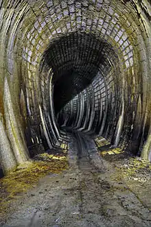
- Blacksmith Tunnel (Italian: Cunicolo del Ferraro), on the eastern side of the mountain, allows to know the system of tunnels and numerous wells closely. A first stretch was paved and equipped with lighting. The bypass connects it with the major tunnel.
- Imperial Tunnel (Italian: Cunicolo Imperiale), located lower compared to the previous one, connected to it through the well no. 23.
- Coppersmith, Machine and Oil-Lamp Tunnels (Italian: Cunicoli del Calderaro, della Macchina e della Lucerna), on the western side of the mountain.[13][40][41]
References
- Servidio, Radmilli, Letta, Messineo et al. 1977, p. 140.
- Campanelli 2001, p. 9.
- "Storia del consorzio" (in Italian). Consorzio di bonifica ovest bacino Liri - Garigliano. Retrieved 6 June 2017.
- Maidl, Bernhard (2018). Faszination Tunnelbau : Geschichte und Geschichten. Berlin: Ernst und Sohn. ISBN 978-3-433-03113-1.
- Abruzzo Molise. Guida d'Italia (in Italian). Touring Club Italiano. 1997. ISBN 88-365-0017-X.
- "La storia dei Cunicoli di Claudio" (in Italian). Il Portale d'Abruzzo. Retrieved 19 December 2016.
- "Elenco degli edifizi monumentali in Italia". archive.org (in Italian). Ministero della pubblica istruzione. 1902. p. 382. Retrieved 19 May 2017.
- Burri 2002.
- Palmieri 2006, p. 17.
- Urso, Gianpaolo, ed. (2000). L'ultimo Cesare: scritti, riforme, progetti, congiure: atti del convegno internazionale, Cividale del Friuli, 16-18 settembre 1999. Fondazione Niccolò Canussio. L'Erma di Bretschneider. ISBN 9788882651091.
- Grossi 2002, p. 65.
- Campanelli 2001, p. 26.
- Tudico, Luigi (2009). "Fucino, il prosciugamento del lago" (PDF) (in Italian). Aercalor.altervista.org. Retrieved 19 May 2017.
- Grossi 2002, p. 24.
- Campanelli 2001, pp. 15–16.
- Santellocco 2004, p. 88.
- Grossi 2002, pp. 24–25.
- Grossi 2002, p. 27.
- Santellocco 2004, pp. 91.
- Palmieri 2006, p. 20.
- Afan de Rivera 1836, p. 30.
- Agenzia Regionale per i Servizi di Sviluppo Agricolo (2000), Scheda tecnica del Fucino (in Italian), Avezzano: ARSSA-Regione Abruzzo, p. 15
- Palmieri 2006, p. 14
- Grossi 2002, p. 67.
- Palanza 1990, p. 43.
- Grossi, Giuseppe. "Il prosciugamento del Fucino" (in Italian). Comune di Avezzano. Retrieved 19 May 2018.
- Palmieri 2006, p. 21.
- Raschiatore, Roberto (9 April 2015). "Si vende l'ex zuccherificio. Area divisa in venti lotti" (in Italian). Il Centro. Retrieved 19 May 2017.
- "Nella conca d'oro una patata di grande qualità" (in Italian). Il Centro. 27 October 2014. Retrieved 19 May 2017.
- Jetti 2016.
- Proia, Francesco (21 April 2015). "Alla scoperta del secondo e sconosciuto emissario Torlonia" (in Italian). Marsica Live. Retrieved 4 May 2017.
- "Una nuova sinergia muove la Marsica intorno ai Cunicoli di Claudio" (in Italian). Marsica Live. Retrieved 19 December 2016.
- "Emissario di Claudio/Torlonia" (in Italian). Fondo Ambiente Italiano. Retrieved 21 December 2017.
- "Cunicoli di Claudio, firmato il protocollo per la valorizzazione del parco archeologico" (in Italian). PatrimonioSos. 24 January 2017. Retrieved 13 June 2017.
- "Abruzzo, erogati i primi finanziamenti per valorizzare i Cunicoli di Claudio ad Avezzano" (in Italian). Il Giornale dell'Arte. 9 June 2017. Retrieved 13 June 2017.
- Servidio, Radmilli, Letta, Messineo et al. 1977, p. 144.
- Santoriello, Marino. "Il prosciugamento" (in Italian). Terre Marsicane. Retrieved 23 May 2017.
- Grossi 2002, p. 66.
- "Cunicoli di Claudio" (in Italian). Regione Abruzzo. Retrieved 19 May 2017.
- Servidio, Radmilli, Letta, Messineo et al. 1977, p. 152.
- Colarossi, Patrizia (19 September 2015). "Cunicoli di Claudio: l'opera idraulica di età romana" (in Italian). MiBACT. Retrieved 19 December 2016.
Bibliography
- Afan de Rivera, Carlo (1836). Progetto della restaurazione dello emissario di Claudio e dello scolo del Fucino (in Italian). Naples: Stamperia e cartiera del Fibreno. SBN IT\ICCU\SBL\0484194.CS1 maint: ref=harv (link)
- Burri, Ezio (2002). Il parco naturalistico archeologico dei cunicoli di Claudio (Avezzano, Italia centrale) (in Italian). Firenze: Associazione Nazionale dei Musei Scientifici (estratto da Museologia scientifica). SBN IT\ICCU\IEI\0325809.CS1 maint: ref=harv (link)
- Campanelli, Adele; et al. (2001). Il tesoro del lago: l'archeologia del Fucino e la Collezione Torlonia (in Italian). Pescara: Carsa edizioni. SBN IT\ICCU\UMC\0099815.CS1 maint: ref=harv (link)
- Grossi, Giuseppe (2002). Marsica: guida storico-archeologica (in Italian). Luco dei Marsi: Aleph. SBN IT\ICCU\RMS\1890083.CS1 maint: ref=harv (link)
- Jetti, Guido (2016). Avezzano e il prosciugamento del Fucino (in Italian). Avezzano: Kirke (repr.). SBN IT\ICCU\RAV\2037877.CS1 maint: ref=harv (link)
- Maria Palanza, Ugo (1990). Avezzano: guida alla storia e alla città moderna (in Italian). Avezzano: Amministrazione comunale. SBN IT\ICCU\AQ1\0060998.CS1 maint: ref=harv (link)
- Palmieri, Eliseo (2006). Avezzano, un secolo di immagini (in Italian). Pescara: Paolo de Siena. SBN IT\ICCU\TER\0011256.CS1 maint: ref=harv (link)
- Santellocco, Attilio Francesco (2004). Marsi: storia e leggenda (in Italian). Luco dei Marsi: Touta Marsa. SBN IT\ICCU\AQ1\0071275.CS1 maint: ref=harv (link)
- Servidio, A.; Radmilli, A. M.; Letta, C.; Messineo, G.; Mincione, G.; Gatto, L.; Vittorini, M.; Astuti, G. (1977). Fucino cento anni: 1877-1977 (in Italian). L'Aquila: Roto-Litografia Abruzzo-Press. SBN IT\ICCU\IEI\0030150.CS1 maint: ref=harv (link)
External links
![]() Media related to Tunnels of Claudius at Wikimedia Commons
Media related to Tunnels of Claudius at Wikimedia Commons
- "Cunicoli di Claudio". regione.abruzzo.it (in Italian). Regione Abruzzo. Retrieved 10 June 2017.
