Uhelná Příbram
Uhelná Příbram (German: Kohl Pribrams) is a market town in Havlíčkův Brod District in the Vysočina Region of the Czech Republic. It has around 500 inhabiotants.
Uhelná Příbram | |
|---|---|
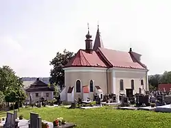 Church of Saint Michael | |
 Flag  Coat of arms | |
 Uhelná Příbram Location in the Czech Republic | |
| Coordinates: 49°46′5″N 15°35′8″E | |
| Country | |
| Region | Vysočina |
| District | Havlíčkův Brod |
| First mentioned | 1352 |
| Area | |
| • Total | 21.81 km2 (8.42 sq mi) |
| Elevation | 485 m (1,591 ft) |
| Population (2020-01-01[1]) | |
| • Total | 498 |
| • Density | 23/km2 (59/sq mi) |
| Time zone | UTC+1 (CET) |
| • Summer (DST) | UTC+2 (CEST) |
| Postal code | 582 45, 582 82, 583 01 |
| Website | www |
Uhelná Příbram lies approximately 18 kilometres (11 mi) north of Havlíčkův Brod, 42 km (26 mi) north of Jihlava, and 91 km (57 mi) south-east of Prague.
Administrative parts
Villages and hamlets of Jarošov, Petrovice u Uhelné Příbramě, Přísečno and Pukšice are administrative parts of Uhelná Příbram.
References
- "Population of Municipalities – 1 January 2020". Czech Statistical Office. 2020-04-30.
| Wikimedia Commons has media related to Uhelná Příbram. |
| Authority control |
|
|---|
This article is issued from Wikipedia. The text is licensed under Creative Commons - Attribution - Sharealike. Additional terms may apply for the media files.