Uki, New South Wales
Uki (/ˈjuːkaɪ/ YOO-ky) is a village situated near Mount Warning in the Tweed Valley of far northern New South Wales, Australia in the Tweed Shire. At the 2006 census, Uki had a population of 203 people.[2] The town's name may have come from an aboriginal word for "small water plant (like a fern) with a yellow flower and edible root".[3]
| Uki New South Wales | |
|---|---|
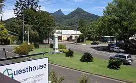 ANZAC Memorial and village. Historic "Sweetnam's Humpy" is visible in the mid-distance and Mt Warning is visible in the background. | |
Uki | |
| Coordinates | 28°25′S 153°20′E |
| Population | 765 (2011 census)[1] |
| Postcode(s) | 2484 |
| Location | 8 km (5 mi) S of Murwillumbah |
| LGA(s) | Tweed Shire |
| State electorate(s) | Lismore |
| Federal Division(s) | Richmond |
There are three approaches to Uki village; from the North it is approximately 15 minutes by road south of the main township of Murwillumbah along the Kyogle Road and 4 km past the turnoff to the World Heritage listed Mount Warning National Park, from the South West along the Kyogle Road from Lismore, Kyogle and Nimbin and from the East along Smiths Creek Road linking Uki to the village of Stokers Siding and the Tweed Valley Way to coastal towns including Brunswick Heads and Byron Bay. It is also possible to travel to Mullumbimby from Uki using gravel back roads and fire trails through the Mount Jerusalem National Park.
Clarrie Hall Dam is located 10 km from Uki, and the area is described as "one of New South Wales’ finest fishing destinations".[4]
Today
Prominent buildings in the village include the historical 'Old Butter Factory' and a primary school. There are several stores including a post office, general store, café, bakery, pharmacy, guesthouse and laundromat. The Mount Warning Hotel, which is a weekend lunch 'stop-over' for touring motorbikes and those out for a weekend drive, burnt down in February 2013. It was subsequently re-built and opened again for business in mid-2015.[5] Uki is the town on which the village of Yurriki in Robert G. Barrett's book The Godson[6] is based.
History
Early pioneers were either timber cutters (usually Australian Red Cedar) or dairy farmers.[7] Photos of The Sisters and Mt Uki near Uki in the early 1900s show these cleared of nearly all vegetation.
Following a rationalisation of the dairy industry in the 1960s, many dairies closed down with farmers turning to beef cattle, which remains a feature of the region today. Tropical fruits have also been grown in the area and cane farming is a prominent agricultural activity in the Tweed Valley itself. The last remaining sawmill is located on the Smith's Creek Road towards the north of the village.
Demographics
In the 2011 census, Uki recorded a population of 765 people, 50.5% female and 49.5% male.
The median age of the Uki population was 45 years, 8 years above the national median of 37.
73.4% of people living in Uki were born in Australia. The other top responses for country of birth were England 6%, New Zealand 3.7%, United States of America 1.3%, Netherlands 0.7%, France 0.5%.
88.5% of people spoke only English at home; the next most common languages were 1.6% German, 0.5% Hebrew, 0.4% French, 0.4% Swedish, 0.4% Spanish.[1]
Sport
The Uki Pythons Soccer Club is located just out of Uki and most of the players are from the town. In 2015, Uki had 2 Senior Men's teams, 1 Senior Women's team, 5 Junior competitive teams (including 1 all girls team) and 6 Junior Miniroos Teams. The club's colours are Dark Green with Yellow trim or Yellow Shirt with Green trim and Dark Green shorts and socks. Uki also offers community touch football through the summer months. All teams are local and various levels of ability are represented. Ages range from 6 to 60.
Notes
- Australian Bureau of Statistics (31 October 2012). "Uki (State Suburb)". 2011 Census QuickStats. Retrieved 16 February 2014.

- Australian Bureau of Statistics (25 October 2007). "Uki (L) (Urban Centre/Locality)". 2006 Census QuickStats. Retrieved 7 February 2010.
- "Uki". Geographical Names Register (GNR) of NSW. Geographical Names Board of New South Wales. Retrieved 11 August 2013.
- Gary Prerost. "Topwater Bassing At Clarrie Hall". Archived from the original on 4 September 2007. Retrieved 10 January 2009.
Clarrie Hall dam can lay claim to being New South Wales' finest topwater lure impoundment, and would have to sit in the top few of all the dams in Australia.
- "Mt Warning Hotel rises from the ashes - Echonetdaily". www.echo.net.au. Retrieved 4 November 2015.
- Barrett, Robert G. (1989). The Godson. Sydney: Pan Books. p. 346. ISBN 0-330-27162-8.
- Connery, Mary Lee (ed) (1987). The Way It Was. Uki, N.S.W.: Uki and South Arm Historical Society. p. 92. ISBN 0-7316-0957-3.CS1 maint: extra text: authors list (link)