Ulleungdo
Ulleungdo (also spelled Ulreungdo; Korean pronunciation: [ulːɯŋdo]) is a South Korean island 120 km (75 mi) east of the Korean Peninsula, formerly known as the Dagelet Island or Argonaut Island in Europe; also known as Yuling-dao (trad. 鬱陵島, simp. 郁陵岛) in Chinese, and Utsuryo-to (鬱陵島) in Japanese.[2][3][4] Volcanic in origin, the rocky steep-sided island is the top of a large stratovolcano which rises from the seafloor, reaching a maximum elevation of 984 metres (3,228 ft) at Seonginbong Peak. The island is 9.5 kilometres (5.9 mi) in length and 10 kilometres (6.2 mi) in width; it has an area of 72.86 km2 (28.13 sq mi).[1] It has a population of 10,426 inhabitants.[5]
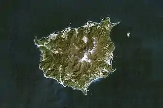 NASA Landsat7 image of Ulleung-do (north oriented at top) | |
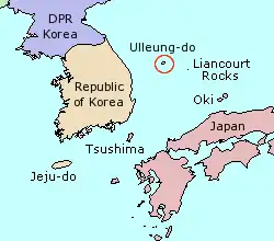 Location of Ulleung-do | |
| Geography | |
|---|---|
| Location | East Sea |
| Coordinates | 37°30′04″N 130°51′23″E |
| Area | 72.86[1] km2 (28.13 sq mi) |
| Highest elevation | 984 m (3228 ft) |
| Administration | |
South Korea | |
| County | Ulleung County |
| Province | North Gyeongsang Province |
North Korea (claimed) | |
| County | Ullŭng County |
| Province | North Kyŏngsang Province |
| Demographics | |
| Population | 9,191 (Sep 2020.) |
| Pop. density | 126/km2 (326/sq mi) |
| Ethnic groups | Koreans |
| Korean name | |
| Hangul | |
| Hanja | |
| Revised Romanization | Ulleungdo |
| McCune–Reischauer | Ullŭngdo |
The island makes up the main part of Ulleung County, North Gyeongsang Province, South Korea and is a popular tourist destination. The main city of Ulleung-do is the port of Dodong (도동; 道洞), which serves as the main ferry port between Ulleung-do and the South Korean mainland. After tourism, the main economic activity is fishing, including its well-known harvest of squid, which can be seen drying in the sun in many places.
History
The island consists primarily of trachyandesite rock. A major explosive eruption about 9,350 years ago reached a Volcanic Explosivity Index of 6 and deposited tephra as far as central Honshū over 800 km (500 mi) away, while producing pyroclastic flows on the island and decapitating its top to form a caldera.
Archaeological evidence indicates that the island has been inhabited since the 1st millennium BC. The first confirmed historical reference to Ulleung-do is in the Samguk Sagi for the year 512. In that year, the Silla general Kim Isabu conquered the island, which had previously been the autonomous nation of Usan-guk. Some accounts relate that he used a number of wooden lions to intimidate the population, threatening to turn them loose unless they surrendered.
Usan-guk did not remain under the Silla rule, however, and the island did not become a permanent political part of Korea until 930, when it was annexed by Goryeo. Remote as it is from the Korean mainland, Ulleung-do was a recurrent security headache for the Goryeo and Joseon dynasties. It was devastated by Jurchen pirate raids in the 11th century, and by Wokou pirate raids in the 14th century. A clash with Japan over fishing rights in the 1690s was precipitated by the Korean fisherman An Yong-bok. In response to these difficulties, Joseon adopted an "empty-island" policy which however proved impossible to enforce. The empty-island policy was officially rescinded in 1881, after which the government sought to encourage additional settlement of Ulleungdo.
American whaleships cruised for right whales off the island between 1848 and 1892.[6] Some went ashore nearby Jukdo to club pinnipeds.[7]
Geography
Ulleungdo is a volcanic island that rose from the seabed between the third and fourth Cenozoic periods, and the part of the island is near the peak of the mountain. It is the summit of the longitudinal volcano, which was created by volcanic activity during the 3rd and 4th Cenozoic Era, and consists of trachyte, andesite, and basalt. Hot spot volcanic activity by the General Yi Sa-bu seamount, dissolved Simheungtaek seamount and Dokdo and Ulleung Island with An Yong-bok seamount was created as well. Dokdo is 4.6 million years ago estimated 2.5 million years ago, and the creation of Ulleungdo to us, 2.5 million years ago in 5,000 years ago.
There is Seonginbong Peak in the center of the island. In the northern part of the island is the only flat basin, the Nari Basin. The Nari Basin was formed from caldera in the crater of the volcano, which was shaped like a Cheonji or Baekrokdam, but the water was drained and the soil was covered with stones and dirt on the bottom of the lake. There are 650 species of plants, including beech, cedar, and pine trees, and 50 species of birds, including black pigeons, and 340 species of insects.
Tourism
Favorite activities for tourists are hiking, fishing, and eating hoe (a Korean raw fish dish). Sightseeing boats make regular three-hour circuits about Ulleung-do, departing from the harbor at Dodong and passing by all the points of interest along the coast, including many interesting rock formations and the small neighboring island of Jukdo. Other scenic sites are Seonginbong, the highest peak on the island (984 m (3,228 ft)); Bongnae waterfall; the "natural icehouse"; and a coastal cliff from which the Liancourt Rocks can be discerned in the distance.[8]
Climate
Ulleung-do has a humid subtropical climate (Köppen climate classification Cfa), though it resembles the west coast of Japan much more than Korea, since in winter rainfall is heavy if less so than in such wet cities as Kanazawa or Akita. Sunshine is also very low in the winter if again not so markedly as in the previously-mentioned Japanese cities.
| Climate data for Ulleung-do, South Korea (1981–2010, extremes 1938–present) | |||||||||||||
|---|---|---|---|---|---|---|---|---|---|---|---|---|---|
| Month | Jan | Feb | Mar | Apr | May | Jun | Jul | Aug | Sep | Oct | Nov | Dec | Year |
| Record high °C (°F) | 14.9 (58.8) |
19.2 (66.6) |
21.8 (71.2) |
26.1 (79.0) |
29.4 (84.9) |
32.2 (90.0) |
34.6 (94.3) |
34.6 (94.3) |
32.4 (90.3) |
27.2 (81.0) |
23.2 (73.8) |
17.9 (64.2) |
34.6 (94.3) |
| Average high °C (°F) | 4.3 (39.7) |
5.3 (41.5) |
9.1 (48.4) |
15.1 (59.2) |
19.3 (66.7) |
22.2 (72.0) |
25.2 (77.4) |
26.7 (80.1) |
23.1 (73.6) |
18.8 (65.8) |
13.1 (55.6) |
7.5 (45.5) |
15.8 (60.4) |
| Daily mean °C (°F) | 1.4 (34.5) |
2.2 (36.0) |
5.4 (41.7) |
11.1 (52.0) |
15.5 (59.9) |
18.8 (65.8) |
22.3 (72.1) |
23.6 (74.5) |
19.8 (67.6) |
15.3 (59.5) |
9.7 (49.5) |
4.4 (39.9) |
12.4 (54.3) |
| Average low °C (°F) | −0.8 (30.6) |
−0.2 (31.6) |
2.5 (36.5) |
7.7 (45.9) |
12.1 (53.8) |
16.0 (60.8) |
20.0 (68.0) |
21.4 (70.5) |
17.4 (63.3) |
12.6 (54.7) |
7.1 (44.8) |
2.0 (35.6) |
9.8 (49.6) |
| Record low °C (°F) | −11.6 (11.1) |
−13.6 (7.5) |
−9.9 (14.2) |
−2.7 (27.1) |
3.8 (38.8) |
7.0 (44.6) |
12.5 (54.5) |
14.7 (58.5) |
8.9 (48.0) |
0.7 (33.3) |
−5.9 (21.4) |
−9.6 (14.7) |
−13.6 (7.5) |
| Average precipitation mm (inches) | 116.2 (4.57) |
78.1 (3.07) |
72.2 (2.84) |
81.3 (3.20) |
105.1 (4.14) |
115.3 (4.54) |
170.2 (6.70) |
167.9 (6.61) |
170.7 (6.72) |
83.9 (3.30) |
105.5 (4.15) |
117.1 (4.61) |
1,383.4 (54.46) |
| Average precipitation days (≥ 0.1 mm) | 18.5 | 14.6 | 11.6 | 8.3 | 8.7 | 9.1 | 12.1 | 11.5 | 9.9 | 9.0 | 12.4 | 16.9 | 142.6 |
| Average snowy days | 17.9 | 13.3 | 7.0 | 0.7 | 0.0 | 0.0 | 0.0 | 0.0 | 0.0 | 0.3 | 3.6 | 12.1 | 54.9 |
| Average relative humidity (%) | 70.1 | 69.6 | 69.8 | 69.2 | 72.1 | 80.4 | 85.9 | 85.0 | 80.3 | 72.5 | 68.6 | 68.5 | 74.3 |
| Mean monthly sunshine hours | 90.4 | 104.1 | 167.2 | 212.0 | 227.3 | 175.0 | 150.7 | 163.3 | 158.7 | 176.8 | 130.0 | 100.6 | 1,856.1 |
| Percent possible sunshine | 29.5 | 34.2 | 45.1 | 53.7 | 51.7 | 39.7 | 33.6 | 38.8 | 42.5 | 50.7 | 42.6 | 33.7 | 41.7 |
| Source: Korea Meteorological Administration. Average[9] Record high[10] Record low[11] Percent sunshine and snowy days[12] | |||||||||||||
Nature
The island and surrounding water were registered as a marine protected area to secure rich biodiversity in 2014.[13]
As above mentioned, North Pacific right whales and pinnipeds were targeted by whalers and sealers in the adjacent waters. Fin whales were also commonly observed historically, and other cetaceans such as minke whales and dolphins may appear around the island.[14][15][16] [17]
Japanese sea lions, now extinct, once bred on the island.[18][19]
References
- "120417(조간)_2012년도_지적통계연보_발간(지적기획과1)" (HWP) (in Korean). 2012-04-16.
- "Prohibition of Passage to Utsuryo Island". Retrieved 4 April 2016.
- Short, John Rennie (2012). Korea: A Cartographic History. Chicago: University of Chicago Press. ISBN 978-0226753645. Retrieved May 29, 2012.
- Narangoa 2014, p. 299.
- "The Island of Ulleung". Official Site of Korea Tourism. Archived from the original on 2014-08-26.
- Splendid, of Edgartown, Apr. 21, 1848, Nicholson Whaling Collection; Cape Horn Pigeon, of New Bedford, Apr. 19, 1892, Kendall Whaling Museum.
- Henry Kneeland, of New Bedford, Apr. 18, 1853. In Cloud, E. C., & McLean, E. (1994). Enoch's voyage: life in a whaleship, 1851-1854. Wakefield, R.I: Moyer Bell.
- 김, 두한 (2018-04-13). "울릉도 성인봉·나리봉, '4월 명품 숲'에". 경북매일. Retrieved 2018-06-16.
- "평년값자료(30년) 울릉도(115)". Korea Meteorological Administration. Retrieved 2011-06-14.
- "기후자료극값(최대값) 8월 일최고기온 (℃) 최고순위, 115 울릉도". Korea Meteorological Administration. Retrieved 2011-06-14.
- "기후자료극값(최대값) 2월 일최저기온 (℃) 최저순위, 115 울릉도". Korea Meteorological Administration. Retrieved 2011-06-14.
- "Climatological Normals of Korea" (PDF). Korea Meteorological Administration. 2011. p. 499 and 649. Archived from the original (PDF) on 7 December 2016. Retrieved 9 December 2016.
- 해양수산부고시제2014-139호(울릉도 주변해역 해양보호구역 지정), 제18417호 / 관보(정호) / 발행일 : 2014. 12. 26. / 83 페이지 / 490.8KB
- 2017. "동해 고래, 한미관계 뿐 아니라 독도 역사와도 연결". Retrieved on August 21, 2017
- Chang K.; Zhang C.; Park C.; Kang; Ju S.; Lee; Wimbush M., eds. (2015). Oceanography of the East Sea (Japan Sea). Springer International Publishing. p. 380. ISBN 9783319227207. Retrieved 2017-08-25.
- Whalelove.com. 참고래 Balaenoptera physalus. Retrieved on August 26, 2017
- "둘도 없는 이 땅의 기경 울릉도를 탐하다 - 자전거생활". www.bicyclelife.net (in Korean). 2019-06-04. Retrieved 2019-06-07.
- Sea Lions/Seals/Fur Seal on Ulleungdo
- Scientists find traces of extinct Dokdo sea lions
- Global Volcanism Program: Ulreung
- Narangoa, Li (2014). Historical Atlas of Northeast Asia, 1590-2010: Korea, Manchuria, Mongolia, Eastern Siberia. New York: Columbia University Press. ISBN 9780231160704.
External links
| Wikimedia Commons has media related to Ulleung Island. |
| Wikivoyage has a travel guide for Ulleungdo. |
- Ulleung County government
- Ulleung.go.kr: Tourist Information (in English)
- Ulleungdo, Dokdo islands to be preserved as National Park
| Authority control |
|---|
