Ulug-Khemsky District
Ulug-Khemsky District (Russian: Улу́г-Хе́мский кожуун; Tuvan: Улуг-Хем кожуун) is an administrative[1] and municipal[3] district (raion, or kozhuun), one of the seventeen in the Tuva Republic, Russia. It is located in the center of the republic and borders Krasnoyarsk Krai in the north, Kyzylsky and Chedi-Kholsky Districts in the east, Ovyursky and Tes-Khemsky Districts in the south, and Chaa-Kholsky District in the west.[2] The area of the district is 5,335.40 square kilometers (2,060.01 sq mi).[3] Its administrative center is the town of Shagonar.[1] As of the 2010 Census, the total population of the district was 19,266, with the population of Shagonar accounting for 56.9% of that number.[4]
Ulug-Khemsky District
Улуг-Хемский кожуун | |
|---|---|
| Other transcription(s) | |
| • Tuvan | Улуг-Хем кожуун |
 View from Mount Khayyrakan in the westerly direction | |
 Coat of arms | |
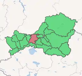
Location of Ulug-Khemsky District in the Tuva Republic | |
| Coordinates: 51°24′N 92°52′E | |
| Country | Russia |
| Federal subject | Tuva Republic[1] |
| Established | September 8, 1923[2] |
| Administrative center | Shagonar[1] |
| Area | |
| • Total | 5,335.40 km2 (2,060.01 sq mi) |
| Population | |
| • Total | 19,266 |
| • Estimate (2018)[5] | 19,216 (−0.3%) |
| • Density | 3.6/km2 (9.4/sq mi) |
| • Urban | 56.9% |
| • Rural | 43.1% |
| Administrative structure | |
| • Administrative divisions | 1 Towns under district jurisdiction (urban settlements), 9 Sumons |
| • Inhabited localities[1] | 1 Cities/towns, 9 Rural localities |
| Municipal structure | |
| • Municipally incorporated as | Ulug-Khemsky Municipal District[3] |
| • Municipal divisions[3] | 1 Urban settlements, 9 Rural settlements |
| Time zone | UTC+7 (MSK+4 |
| OKTMO ID | 93654000 |
| Website | http://ulughem17.ru |
| 2010 Census | 19,266[4] |
|---|---|
| 2002 Census | 19,461[7] |
| 1989 Census | 29,866[8] |
| 1979 Census | 25,700[9] |
History
Ulug-Khemsky Kozhuun was established within the Tuvan People's Republic on September 8, 1923.[2] It became Ulug-Khemsky District on October 13, 1944, when the Tuvan People's Republic became a part of the Soviet Union.[2] In 1957, its territory was enlarged by appending Bayan-Kolsky Selsoviet.[2] In April 1961, Chaa-Kholsky District was merged into Ulug-Khemsky District.[2] On February 25, 1975, Bayan-Kolsky Selsoviet was transferred back to Kyzylsky District, and Chaa-Kholsky District was split back out on December 20, 1991.[2] When Chedi-Kholsky District was established on December 21, 1992, Khonderginsky Selsoviet of Ulug-Khemsky District was transferred to it.[2]
References
Notes
- Resolution #1648 ZP-1
- Official website of Ulug-Khemsky District. History (in Russian)
- Law #268 VKh-1
- Russian Federal State Statistics Service (2011). "Всероссийская перепись населения 2010 года. Том 1" [2010 All-Russian Population Census, vol. 1]. Всероссийская перепись населения 2010 года [2010 All-Russia Population Census] (in Russian). Federal State Statistics Service.
- "26. Численность постоянного населения Российской Федерации по муниципальным образованиям на 1 января 2018 года". Federal State Statistics Service. Retrieved January 23, 2019.
- "Об исчислении времени". Официальный интернет-портал правовой информации (in Russian). June 3, 2011. Retrieved January 19, 2019.
- Russian Federal State Statistics Service (May 21, 2004). "Численность населения России, субъектов Российской Федерации в составе федеральных округов, районов, городских поселений, сельских населённых пунктов – районных центров и сельских населённых пунктов с населением 3 тысячи и более человек" [Population of Russia, Its Federal Districts, Federal Subjects, Districts, Urban Localities, Rural Localities—Administrative Centers, and Rural Localities with Population of Over 3,000] (XLS). Всероссийская перепись населения 2002 года [All-Russia Population Census of 2002] (in Russian).
- "Всесоюзная перепись населения 1989 г. Численность наличного населения союзных и автономных республик, автономных областей и округов, краёв, областей, районов, городских поселений и сёл-райцентров" [All Union Population Census of 1989: Present Population of Union and Autonomous Republics, Autonomous Oblasts and Okrugs, Krais, Oblasts, Districts, Urban Settlements, and Villages Serving as District Administrative Centers]. Всесоюзная перепись населения 1989 года [All-Union Population Census of 1989] (in Russian). Институт демографии Национального исследовательского университета: Высшая школа экономики [Institute of Demography at the National Research University: Higher School of Economics]. 1989 – via Demoscope Weekly.
- "Всесоюзная перепись населения 1979 г. Национальный состав населения по регионам России" [All Union Population Census of 1979. Ethnic composition of the population by regions of Russia] (XLS). Всесоюзная перепись населения 1979 года [All-Union Population Census of 1979] (in Russian). 1979 – via Demoscope Weekly (website of the Institute of Demographics of the State University—Higher School of Economics.
Sources
- Законодательная палата Великого Хурала Республики Тыва. Постановление №1648 ЗП-1 от 21 декабря 2005 г. «Об утверждении реестра административно-территориального деления Республики Тыва», в ред. Постановления №455 ЗП-2 от 21 ноября 2007 г «О внесении изменения в реестр административно-территориального деления Республики Тыва». Вступил в силу 21 декабря 2005 г. Опубликован: "Тувинская правда", №2, 12 января 2006 г. (Legislative Chamber of the Great Khural of the Tyva Republic. Resolution #1648 ZP-1 of December 21, 2005 On Establishing the Registry of the Administrative-Territorial Division of the Tyva Republic, as amended by the Resolution #455 ZP-2 of November 21, 2007 On Amending the Registry of the Administrative-Territorial Division of the Tyva Republic. Effective as of December 21, 2005.).
- Великий Хурал (парламент) Республики Тыва. Закон №268 ВХ-1 от 24 декабря 2010 г. «О статусе муниципальных образований Республики Тыва», в ред. Закона №837 ВХ-1 от 10 октября 2011 г. «О внесении изменений в Закон Республики Тыва "О статусе муниципальных образований Республики Тыва"». Вступил в силу со дня официального опубликования. Опубликован: "Тувинская правда", №178 (без приложений), 31 декабря 2010 г. (Great Khural (Parliament) of the Tyva Republic. Law #268 VKh-1 of December 24, 2010 On the Status of the Municipal Formations of the Tyva Republic, as amended by the Law #837 VKh-1 of October 10, 2011 On Amending the Law of the Tyva Republic "On the Status of the Municipal Formations of the Tyva Republic". Effective as of the official publication date.).
| Districts (kozhuuns) | |||
|---|---|---|---|
| Cities and towns | |||
| Urban-type settlements | |||