Umarga Taluka
Umarga(Omerga) Tehsil (In Marathi उमरगा तालुका) is a tehsil/ taluka/ subdistrict in Osmanabad district, Maharashtra on the Deccan Plateau of India. The town of Umarga is the administrative headquarters of the tehsil. There are 79 panchayat villages in Umarga Tehsil.[2]
Umarga(Omerga) Tehsil
उमरगा तालुका | |
|---|---|
Tehsil | |
| Nickname(s): annand nagar | |
 Umarga(Omerga) Tehsil Location in Maharashtra, India | |
| Coordinates: 17°53′N 076°38′E | |
| Country | |
| State | Maharashtra [omerga] |
| District | Osmanabad |
| Founded by | tulshiram ingale,hanmantrao ingale,.... |
| Languages | |
| • Official | Marathi |
| Time zone | UTC+5:30 (IST) |
| Lok Sabha constituency | Osmanabad |
| Vidhan Sabha constituency | Umarga[1] |
History
The Killari earthquake of 1993 affected most parts of the Umarga Tehsil. Approximately 2,500–3,000 lives were lost. One of the famous hemadpanti mahavad temple along india.
Demographics
In the 2001 Indian census, Umarga Tehsil had a population of 241,339, with 123,852 (51.3%) males and 117,487 (48.7%) females, for a gender ratio of 949 females per thousand males.[3] The tehsil was 80.4% rural in 2001.[3]
In the 2011 census, Umarga Tehsil had 269,849 inhabitants[4] and a gender ratio of 946 females per thousand males.[5] The tehsil was 74.5% rural.[4] The literacy rate in 2011 was 75.28% overall in Umarga Tehsil, with a rate of 84.73% for males and 65.35% for females.[6] In 2011 in Umarga Tehsil, 11.7% of the population was 0 to 6 years of age.[4]
Marathi is the most commonly used language in Omerga, with around 93% speaking Marathi as their primary language. Kannada is also spoken by some.[7][8]
Transportation
National Highways
Below National Highways passes through the Umarga Tehsil.[9]
1. NH-65: Pune-Indapur-Solapur-Umarga-Hyderabad-Vijayawada-Machilipatnam(Andhra Pradesh)
(Villages from Umarga tehsil on this NH are- Yenegur-Dalimb-Yeli-Jakekur-Umarga-Turori)
2. NH-548B: Mantha-Selu-Pathari-Sonpeth-Parali-Ambajogai-Latur-Ausa-Umarga-Yenegur-Murum-Alur-Akkalkot-Nagansur-Vijayapura-Athani-Chikhodi-Sankeshwar-Gotur(Karnataka)
Towns and villages
There are two towns in Umarga Tehsil, Umarga and Murum, both of which have municipal councils. Among the villages in the tehsil are:[10]
- Acharya Tanda
- Alur
- Ambarnagar
- Ashta Jahangir
- Aurad
- Babalsur
- Balsur
- Baradwadi
- Belamb
- Bendga
- Bhagatwadi
- Bhikar Sangvi
- Bhusani
- Bori
- Chandkal
- Chinchkota
- Chincholi Bhuyar
- Chincholi Jahagir
- Chirewadi
- Dabka
- Dalimb
- Dawal Malikwadi
- Dhaktiwadi
- Dhanora Dagad
- Diggi
- Dudhanal
- Ekundi Jahagir
- Ekundiwadi
- Ekurga
- Ekurgawadi
- Fulsingnagar
- Ganeshnagar
- Gugalgaon
- Gunjoti
- Gunjotiwadi
- Guruwadi
- Handral
- Hippargarao
- Ingole Tanda
- Jagadalwadi
- Jakekur
- Jakekurwadi
- Jawalga Bet
- Kadamapur
- Kaddora
- Kader
- Kaldeo Nimbala
- Kalnimbala
- Kantekur
- Karali
- Kasgi
- Kasgiwadi
- Katewadi
- Kawatha
- Kesar Jawalga
- Kolewadi
- Kolsur (G)
- Kolsur (K)
- Koral
- Koregaon
- Koregaonwadi
- Kothali
- Kunhali
- Madaj
- Mahalingraiwadi
- Malgi
- Malgiwadi
- Manegopal
- Matola Kh.
- Mulaj
- Murli
- Murum (Rural)
- Nagral
- Nai Chakur
- Naiknagar
- Narangwadi
- Palasgaon
- Paraskheda
- Peth Sangvi
- Rampur
- Samudral
- Sawalsur
- Sundarwadi
- Supatgaon
- Talmod
- Thorliwadi
- Trikoli
- Tugaon
- Turori
- Umarga (Rural)
- Varnalwadi
- Vhantal
- Wagdari
- Yeli
- Yenegur
Monuments, temples and attractions
- One of the famous hamadepainti Mahadev temple among the maharashtra in Brahman Galli, Deshmukh wada Gunjoti, omerga.
- Famous Shiv temple named "Jata Shankar" is located in Mulaj 10 km from Omerga.
- Shri Mathurapuri Maharaj(MAAT)is located in Babalasur(old).
- Old historic Deshmukh wada at Brahman galli,Gunjoti Village Omegra .
- Shri Premnath Maharaj is a temple and religious place in the village of Madaj (Mathmal). The god/saint Premnath Maharaj belongs to one of the sishyas (disciples) of Navnath. Premnath Maharaj took his Samadhi. Every year an annual yatra (religious fair) is held in the month of November. People come here in large number to take darshan during the yatra.
- Old Madaj is an historic village which has contributed in various movements.
- The Shri Narayana Temple is located in Madaj. It is a Hemadpanthi temple with Barav.
- There are temples for Shiv and Ganesha in Shivaji Chowk.
- Holy places such as Amrutkund (the water of eternal life)
- Shri Ramligeshwar is a well-known temple and religious place in the village of Yeli.
- Sri Swaminarayan Mandir is located in Samudral. Also the Narsinh (Male lion God)Temple is there in this village. Every year an annual yatra (religious fair) is held in the month of May.-Vikram Dipankar.
- Shri Nath Mandir is the temple of Saint Eknath. Also has 2.5 Feet statue of Shri Vitthal. Every year there is a Festival called NATH-SHASHTHI, which includes Bhajan, Kirtan, Ann-daan.
- In kaldeo Nimbala there is temple of shiva Every year in April festival ie "YAYRA" After 12days of gudi padwa which includes ,shobhi daaru,Tamasha, palkhi,Bhajan , Bharud,10-15 thousands peoples Mahaprasad on Mahaarti-Subhash Manikrao kamble
References
- "Assembly Constituencies-Post delimitation: Maharashtra: Osmanabad District" (PDF). National Informatics Centre, Government of India. Archived from the original (PDF) on 5 May 2013.
- "Reports of National Panchayat Directory: Village Panchayat Names of Umarga, Osmanabad, Maharashtra". Ministry of Panchayati Raj, Government of India. Archived from the original on 5 May 2013.
- "Census 2001 Population Finder: Maharashtra: Osmanabad: Umarga". Office of The Registrar General & Census Commissioner, Ministry of Home Affairs, Government of India.
- "Population, Child Population in the age-group 0–6 and Literates by residence and sex, State, Districts, Tehsils 2011: Maharashtra" (PDF). Press Information Bureau, Mumbai. p. 41.
- "Sex ratio of Population and Child Population in the age-group 0–6, State, Districts, Tehsils 2011: Maharashtra" (PDF). Press Information Bureau, Mumbai. p. 8.
- "Literacy rates by residence and sex, State, Districts, Tehsils 2011: Maharashtra" (PDF). Press Information Bureau, Mumbai. p. 17.
- The Dynasties of the Kanarese Districts of the Bombay Presidency (1894) J.F. Fleet, Gazetteer of the Bombay Presidency (Vol-1, Part-II, Book-III) ISBN 81-206-0277-3
- "Kanarese". DSAL The Record News.
- Details of National Highways (NHs) as on 31.03.2019
- "NPR Report: Maharashtra: Osmanabad: Umarga". National Population Register, Ministry of Home Affairs, Government of India. 2011.
Osmanabad district topics | ||
|---|---|---|
| History | 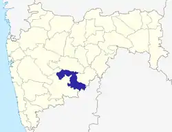 | |
| Cities and towns | ||
| Monuments | ||
| Lok Sabha constituencies | ||
| Vidhan Sabha constituencies | ||