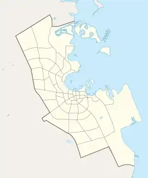
Umm Lekhba
Umm Lekhba (Arabic: ام لخبا, romanized: Umm Lakhbā) is a district in Qatar, located in the municipality of Doha.[1] It was previously known as Al Duhail South, or alternatively, South Duhail.[2]
Umm Lekhba
ام لخبا | |
|---|---|
District | |
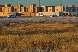 Grass species Rostraria pumila growing in Umm Lekhba | |
 Umm Lekhba 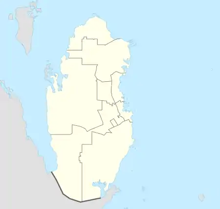 Umm Lekhba | |
| Coordinates: 25°20′25″N 51°28′15″E | |
| Country | |
| Municipality | Ad-Dawhah |
| Zone | Zone 31 |
| District no. | 28 |
| Area | |
| • Total | 3.1 km2 (1.2 sq mi) |
| Population (2010) | |
| • Total | 9,871 |
| • Density | 3,200/km2 (8,200/sq mi) |
Etymology
In Arabic, "umm" literally means mother, but in this context is used as a prefix for specific geographic features. The second portion of the name, "lekhba", originates from the Arabic word "khabaa", which is translated as "to hide". This name was given in reference to the fact that the area is relatively discreet since it lies in a depression.[3]
Landmarks
- Mercedes-Benz, Nasser Bin Khaled Autombiles on Al Uqouriyat Street.[3]
- Hamad Medical Corporation Ambulance Service HQ on Al Markhiya Street.[3]
- Tawar Mall on Al Markhiya Street opened in 2018 and covers an area of roughly 90,000 square meters.[3][4]
- Shafallah Centre For Children With Special Needs on Zaid Bin Muhajer Street.[3]
Transport
Major roads that run through the district are Al Markhiya Street, Al Khafji Street, and Al Shamal Road.[5]
Demographics
As of the 2010 census, the district comprised 1,540 housing units[6] and 331 establishments.[7] There were 9,871 people living in the district, of which 51% were male and 49% were female. Out of the 9,871 inhabitants, 68% were 20 years of age or older and 32% were under the age of 20. The literacy rate stood at 97.3%.[8]
Employed persons made up 55% of the total population. Females accounted for 40% of the working population, while males accounted for 60% of the working population.[8]
| Year | Population |
|---|---|
| 1986[9] | 927 |
| 1997[10] | 1,493 |
| 2004[2] | 4,486 |
| 2010[1] | 9,871 |
Education
The following schools are located in Umm Lekhba:
| Name of School | Curriculum | Grade | Genders | Official Website | Ref |
|---|---|---|---|---|---|
| Al Andalus Secondary Private School for Boys | Independent | Secondary | Male-only | Official website | [11] |
| Qatar Al-Hadeetha | Independent | Kindergarten | Both | N/A | [12] |
| Qatar Canadian School | International | Kindergarten – Secondary | Both | Official website | [13] |
References
- "2010 population census" (PDF). Qatar Statistics Authority. Retrieved 29 June 2015.
- "2004 population census". Qatar Statistics Authority. Retrieved 1 July 2015.
- "District map". The Centre for Geographic Information Systems of Qatar. Retrieved 29 December 2018.
- "Qatar set to get nine more malls". Gulf Times. 6 February 2019. Retrieved 7 February 2019.
- "Index map of Qatar". ArcGIS.com. Retrieved 25 August 2019.
- "Housing units, by type of unit and zone (April 2010)" (PDF). Qatar Statistics Authority. Retrieved 7 August 2015.
- "Establishments by status of establishment and zone (April 2010)" (PDF). Qatar Statistics Authority. Retrieved 7 August 2015.
- "Geo Statistics Application". Ministry of Development Planning and Statistics. Archived from the original on 11 September 2012. Retrieved 7 August 2015.
- "1986 population census" (PDF). Qatar Statistics Authority. Archived from the original (PDF) on 3 July 2015. Retrieved 2 July 2015.
- "1997 population census" (PDF). Qatar Statistics Authority. Archived from the original (PDF) on 29 May 2015. Retrieved 2 July 2015.
- "Al Andalus Preparatory Secondary Private School for Boys". Supreme Education Council. Retrieved 18 July 2015.
- "Qatar Al-Hadeetha". Supreme Education Council. Retrieved 18 July 2015.
- "Qatar Canadian School (Blyth Academy Qatar)". The Canadian Information Centre for International Credentials. Retrieved 18 July 2015.