University Heights (Washington, D.C.)
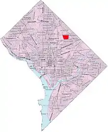
University Heights is a neighborhood adjacent to The Catholic University of America in Ward 5 of Northeast Washington, D.C. in the Upper Northeast area element.[1] It is located east of the University and west of the Franciscan Monastery, bounded by the tracks for the Red Line of the Washington Metro to the west; 14th Street NE to the east; Taylor Street to the north; and Otis Street to the south. University Heights is in DC Neighborhood Cluster 20[2] along with the Michigan Park (Washington, D.C.) and North Michigan Park neighborhoods.
University Heights is often thought of as a section of the Brookland neighborhood, largely because Brookland Elementary School is inside University Heights, but is actually a separate neighborhood north of Brookland proper.
Contained within University Heights are Fort Bunker Hill Park and Turkey Thicket Park & Recreation Center.
References
External links
 Media related to University Heights (Washington, D.C.) at Wikimedia Commons