Upalco, Utah
Upalco is an unincorporated community in eastern Duchesne County, Utah, United States.[1]
Upalco, Utah | |
|---|---|
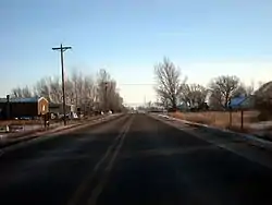 Looking south along State Route 87 in Upalco, December 2008 | |
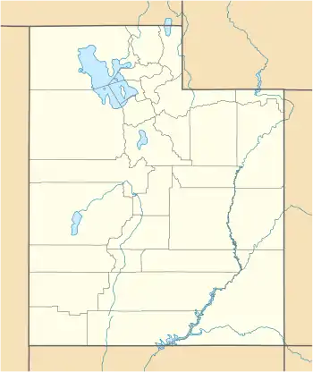 Upalco Location of Upalco within the State of Utah  Upalco Location of Upalco within the United States | |
| Coordinates: 40°16′41″N 110°13′06″W | |
| Country | United States |
| State | Utah |
| County | Duchesne |
| Elevation | 5,755 ft (1,754 m) |
| Time zone | UTC-7 (Mountain (MST)) |
| • Summer (DST) | UTC-6 (MDT) |
| ZIP codes | 84002 |
| Area code(s) | 435 |
| GNIS feature ID | 1433790[1] |
Description
The community is located in the Uinta Basin on the Uintah and Ouray Indian Reservation, approximately 7.5 miles (12.1 km) southeast of the town of Altamont[2] and has an elevation of 5,755 feet (1,754 m).[1] Upalco uses the same ZIP code (84007) that is assigned to Bluebell, a census-designated place located about 5.5 miles (8.9 km) to the north.[3]
Upalco was originally named Lake Fork, after the nearby Lake Fork River, which flows southerly to the west of the community. The name Upalco came from the initial letters of Utah Power and Light Company, which provided funding for an associated, but unidentified project.[2] The Big Sand Wash Reservoir is located about one mile (1.6 km) north of Upalco. (Big Sand State Park, a former Utah state park, was located at the reservoir.)[4][5][Note 1]
Road access to Upalco is primarily by State Route 87 (SR‑87), which passes north–south through the community.[4]
History
The section of highway that passes north–south through Upalco (and is now designated as SR‑87) was previously part of the former State Route 86 (SR‑86). From 1935 to 1964 the road that ran from U.S. Route 40 (US‑40) in Bridgeland northerly to Altonah (via Upalco and Altamont) was designated as SR‑86. (Prior to 1977, this section of US‑40 was also designated as State Route 6 [SR‑6]). Near the southern edge of Uplaco was a junction on SR‑86, from which SR‑87 ran east, via Ioka, to Ioka Junction (the junction of US‑40 [SR‑6] and SR‑87, southwest of Roosevelt).[6][7]
In 1964, the section of the former SR‑86 from the junction near the southern edge of Upalco northerly (through the community) to Altamont, was added to the west end of SR‑87. (The section of the former SR‑86 from Altamont north to Altonah was transferred to the newly designated State Route 221.) In 1969, what left of SR‑86 (the approximate 10 miles [16 km] between US‑40 [SR‑6] near Bridgland and Upalco which remained after the 1964 changes) was deleted from the state highway system. (The following year, sections of the former SR‑221, the former State Route 134, and the current State Route 35 were added to the north [west] end of SR‑87. The result was the current routing SR‑87, which runs northerly from Duchesne to Altamont, via Boneta, and then southwesterly to Ioka Junction, via Upalco and Ioka.)[6][7]
See also
![]() Utah portal
Utah portal
Notes
- While the former Big Sand State Park on the Big Sand Wash Reservoir (also known as Big Sand State Beach)[5] is no longer a state park, it is still a recreation area that is managed by the Utah Department of Natural Resources (DNR), just not the Utah Division of Parks and Recreation (a division of the DNR).
References
- U.S. Geological Survey Geographic Names Information System: Upalco
- Van Cott, John W. (1990). Utah Place Names: A Comprehensive Guide to the Origins of Geographic Names: A Compilation. Salt Lake City: University of Utah Press. p. 380. ISBN 978-0-87480-345-7. OCLC 797284427. Retrieved 29 Jun 2020.
- "Search Results for ZIP code 84007". zipinfo.com. CD Light, LLC. Retrieved 29 Jun 2020.
- Google (29 Jun 2020). "Upalco, Utah 84066" (Map). Google Maps. Google. Retrieved 29 Jun 2020.
Note: Google Maps indicates an incorrect ZIP Code of 84066, which is for Roosevelt. not the correct 84007. - U.S. Geological Survey Geographic Names Information System: Big Sand State Park
- "Highway Resolutions: Route 86" (PDF). drive.google.com, via udot.utah.gov. Utah Department of Transportation. Nov 2011. Retrieved 29 Jun 2020 – via Data, Technology & Analytics Division: Highway Reference & State Road Resolutions Information.
- "Highway Resolutions: Route 87" (PDF). drive.google.com, via udot.utah.gov. Utah Department of Transportation. Nov 2011. Retrieved 29 Jun 2020 – via Data, Technology & Analytics Division: Highway Reference & State Road Resolutions Information.
External links
![]() Media related to Upalco, Utah at Wikimedia Commons
Media related to Upalco, Utah at Wikimedia Commons
Municipalities and communities of Duchesne County, Utah, United States | ||
|---|---|---|
| Cities | 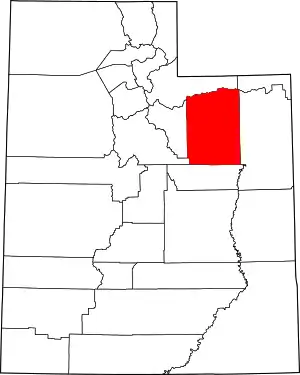 Map of Utah highlighting Duchesne County | |
| Towns | ||
| CDPs | ||
| Unincorporated communities | ||
| Indian reservation | ||
| Ghost town | ||
| Footnotes | ‡This populated place also has portions in an adjacent county or counties | |
| ||
