Upper Angara
The Upper Angara (Russian: Верхняя Ангара, Verkhnyaya Angara; Buryat: Дээдэ Ангар, Deede Angar) is a river in Siberia to the north of Lake Baikal. It is 438 kilometres (272 mi) long, and has a drainage basin of 21,400 square kilometres (8,300 sq mi).[1] It rises north-east of Lake Baikal, flowing south-west through the Buryat Republic and eventually into the lake. It is partly navigable. The Baikal Amur Mainline runs along the north side of the river northeast up its valley, crossing between Anamakit and Novy Uoyan and crossing the river a second time upstream before heading into the mountains.[2]
| Upper Angara | |
|---|---|
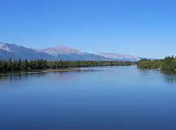 View from the BAM railway bridge across the Upper Angara near Novy Uoyan | |
| Location | |
| Country | Russia |
| Physical characteristics | |
| Mouth | Lake Baikal |
• coordinates | 55.7417°N 109.892°E |
| Length | 438 km (272 mi) |
| Basin size | 21,400 km2 (8,300 sq mi) |
| Basin features | |
| Progression | Lake Baikal→ Angara→ Yenisey→ Kara Sea |
References
- Река Верхняя Ангара in the State Water Register of Russia (Russian)
- Wikimapia approximate site of basin
External links
- , Encyclopædia Britannica, 9th ed., Vol. II, New York: Charles Scribner's Sons, 1878, p. 26.
This article is issued from Wikipedia. The text is licensed under Creative Commons - Attribution - Sharealike. Additional terms may apply for the media files.
