Utah State Route 8
State Route 8 (SR-8) is a short state highway in the southwestern portion of the U.S. state of Utah, running entirely within the city of St. George. The route connects SR-18 to Dixie Downs Road via Sunset Boulevard in a span of 1.3 miles (2.09 km). Prior to 1999, SR-8 extended north to Snow Canyon State Park. However, the route was truncated to its current point that year.
| ||||
|---|---|---|---|---|
| Sunset Boulevard | ||||
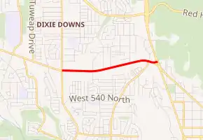
SR-8 highlighted in red | ||||
| Route information | ||||
| Defined by Utah Code §72-4-106 | ||||
| Maintained by UDOT | ||||
| Length | 1.303 mi[1] (2.097 km) | |||
| Existed | 1996–present | |||
| Major junctions | ||||
| West end | Dixie Downs Road in St. George | |||
| East end | ||||
| Location | ||||
| Counties | Washington | |||
| Highway system | ||||
| ||||

Route description
SR-8 begins at SR-18 on the northwestern side of St. George and heads west-southwest through a residential portion of the city on Sunset Boulevard as a five-lane undivided highway. Past Westridge Drive, the road straightens out to the west and soon terminates at Dixie Downs Road.[2]
The entire route has been included in the National Highway System.[3]
History
SR-8 was added to the state highway system in 1910,[4] and in the 1920s it became part of US-91.[5] After the new alignment of I-15 was built south from St. George, old US-91 southwest of SR-18, including present SR-8, was removed from the state highway system in 1974.[4]
State Route 300 was designated in 1972 to serve Snow Canyon State Park, running from SR-18 south to the southern boundary of the park.[6] In 1991, the Utah Transportation Commission passed a resolution to create a new State Route 8, pending roadway improvements, which would absorb the entire length of SR-300, and continue south through Ivins on Center Street and 200 East and southeast on Santa Clara Drive and Sunset Boulevard (old US-91) back to SR-18. Sunset Boulevard between SR-18 and Dixie Downs Road was so improved and added to the state highway system in 1996, and at that time SR-300 was renumbered as a second piece of SR-8. As requested by the Utah Division of Parks and Recreation so they could carry out their resource management plan, the latter portion was removed from the state highway system in 1999, leaving only the present extent of SR-8.[7]
Major intersections
The entire route is in St. George, Washington County.
| mi[1] | km | Destinations | Notes | ||
|---|---|---|---|---|---|
| 0.000 | 0.000 | Dixie Downs Road | Western terminus | ||
| 1.303 | 2.097 | Eastern terminus | |||
| 1.000 mi = 1.609 km; 1.000 km = 0.621 mi | |||||
References
- UDOT Highway Reference, SR-8
- Google. "SR-8 overview" (Map). Google Maps. Google.
- "Utah National Highway System". UDOT Data Portal. Retrieved February 21, 2019.
- Utah Department of Transportation, Highway Resolutions: "Route 1". (35.4 MB), updated September 2007, accessed May 2008
- Rand McNally Auto Road Atlas, 1926
- Utah Department of Transportation, Highway Resolutions: "Route 300". (6.50 MB), updated December 2007, accessed May 2008
- Utah Department of Transportation, Highway Resolutions: "Route 8". (16.8 MB), updated September 2007, accessed May 2008