Uvari
Uvari is a coastal village in Thisayanvilai[1] Taluk, Tirunelveli district, Tamil Nadu, India. It is also called Karaichuthu Uvari.[2][3] The total geographical area of the Uvari is around 3 km2 (1.2 sq mi). Uvari is surrounded by Idaiyangudi, Navaladi, Kuttom and the Bay of Bengal. The mean maximum temperature is around 37 °C (99 °F) in summer and 17 °C (63 °F) in winter, with humidity levels over 65 percent. The rainy season starts between October and January. Uvari is rich in mineral resources like limestone, Ilmenite, and red garnet sands.[4]
Uvari
Karaichuthu Uvari | |
|---|---|
Village | |
 Uvari Location in Tamil Nadu, India | |
| Coordinates: 8.286205°N 77.899305°E | |
| Country | |
| State | Tamil Nadu |
| District | Tirunelveli district |
| Elevation | 12.44 m (40.81 ft) |
| Population (2001) | |
| • Total | 25,000 |
| Languages | |
| • Official | Tamil |
| Time zone | UTC+5:30 (IST) |
Economy
Local inhabitants primarily work as farmers, sailors or fishermen.
Education
Seven schools are located in Uvari.
- St. Mary's Primary School
- St. Mary's Hr Secondary School
- St. Joseph Middle School
- St. Mother Teresa School
- TDTA Primary School
- Hindu Middle School
- Malaviya Vidya Kendram[5]
Health care
Two hospitals are located in Uvari.
- St. Joseph Hospital
- Government Primary Healthcare Hospital
Facilities
Two banks are located in Uvari.
- Central Bank of India (with ATM) [6][7]
- Canara Bank (with ATM)[8]
- Muthoot Finance[9]
- Muthoot Fincorp [10]
Post Office (627651)[11]
BSNL Telephone Exchange (277 series)
Religion
Hinduism and Christianity are the most commonly practiced religions in Uvari.
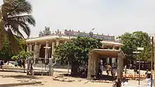
Uvari is home to the prominent Hindu Suyambulinga Swamy Temple.[12] It is said to have originated approximately 500 years ago when "A milk vendor facing some difficulties on his usual way by the root of a Kadamba tree. When he cut the Kadamba tree root, blood began to flow from the spot. A voice from the sky (Asareeri) directed the milk vendor to construct a temple there. The temple was first built with palm leaves which later grew into a stone construction.The main prayer commitment is that people carry the sea sand in 11 or 41 baskets and put it near the temple."[13]
Christian churches include:
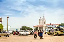
- St. Anthony's Shrine Basilica, a Catholic church dedicated to St. Anthony of Padua, and the only place in Tamil Nadu that has a St. Anthony's church beside the sea.
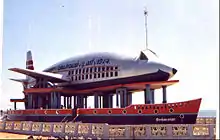
- The Kappal Matha Church (Our Lady of Good Health), in the form of a ship carrying an airplane. The original church of St. Mary was damaged by sea erosion and replaced by this one, built in 1974. It features four shrines and many grottos.
- St. Andrew's Church
- Selva Matha Church (Our Lady of Good Wealth)
- Velankanni Matha Church (Our Lady of Good Health)
History
According to Tamil history, the citizens of Uvari were called Bharathar's of the Neithal (ocean) World. Uvari's historical name was Obeer Pattanam. It was ruled by the Pandyan dynasty.
In the 1530s, Portuguese and Spanish missionaries from Goa arrived and converted many Bharathars to the Roman Catholic religion. The Portuguese priests, acting as godfathers, gave surnames such as Fernando to the converted. Pandya retains a fish on its flag, a symbol of this era.
Legend has it that the crew of a Portuguese ship that sailed near Uvari in the seventeenth century contracted cholera. In an attempt to avert death, a carpenter aboard the ship carved an image of Saint Anthony (Anthony of Padua).[14] Soon after, the entire crew were restored to health. When the ship docked at Uvari, the sailors placed the statue inside a hut in the village. In the 1940s, the villagers built a church with the original statue of St. Anthony holding the infant Jesus in his hand. St Anthony is said to perform many miracles daily for the people who flock there with faith in his intercession, therefore the church was upgraded to a shrine.[15] Uvari is visited by Hindus and Christians from all over South India.
Transport
Uvari is 80 km (50 mi) from Thoothukudi, 40 km (25 mi) from Tiruchendur, 54 km (34 mi) from Nagercoil, 48 km (30 mi) from Kaniyakumari, 75 km (47 mi) from Tirunelveli, 230 km (140 mi) from Madurai, and 260 km (160 mi) from Rameswaram.
The village has no train service. The nearest railway's stations are located in Tiruchendur, 40 km (25 mi) away, and Kaniyakumari, 48 km (30 mi) away. The nearest airport is Tuticorin Airport, 100 km (62 mi) away.
References
- "Karichuthu Uvari Revenue Village" (PDF). Official Tirunelveli District Website. Tamilnadu Government. Retrieved 31 August 2020.
- "Karaichuthu Uvari village in Thisaiyanvilai taluk". Official Tirunelveli District Government Website. Tamilnadu Government. Retrieved 31 August 2020.
- "Karichuthu Uvari Revenue Village" (PDF). Official Tirunelveli District Website. Tamilnadu Government. Retrieved 31 August 2020.
- "DISTRICT SURVEY REPORT FOR ROUGH STONE TIRUNELVELI DISTRICT" (PDF). Government of Tamil Nadu, Department of Geology and Mining. 2019. Retrieved 27 August 2020.
- "Malaviya Vidya kendram". icbse.com. icbse.com. Retrieved 10 October 2020.
- "Central bank of India ATM List". Central Bank of India. Central Bank of India. Retrieved 20 July 2020.
- "Central Bank of India Branch Locator". www.centralbankofindia.co.in. Central Bank of India. Retrieved 20 July 2020.
- "Uvari Canara Bank Branch". Canara Bank Branch Locator. Retrieved 20 July 2020.
- "muthoot financ locator". www.muthootfinance.com. Retrieved 20 July 2020.
- "muthoot fincorp locator". www.muthootfincorp.com. Retrieved 20 July 2020.
- "India Post Pincode Locator service". /www.indiapost.gov.in. Retrieved 20 July 2020.
- https://temple.dinamalar.com/en/new_en.php?id=793
- "Uvari Suyambulinga Swamy Temple | Uvari.info". Retrieved 15 July 2020.
- "Anthony of Padua". britannica.com. Retrieved 31 August 2020.
- Vernacular Catholicism, vernacular saints : Selva J. Raj on "Being Catholic the Tamil way". Raj, Selva J., Locklin, Reid B. Albany. ISBN 978-1-4384-6505-0. OCLC 956984843.CS1 maint: others (link)
External links
| Wikimedia Commons has media related to Uvari. |
