Vöckla
The Vöckla has a length of 47 km (29 mi), its basin is about 450 km2 (170 sq mi), the medium flux 8.7 m3/s (310 cu ft/s). The Vöckla originates northeast of the Mondsee. Created by several springs, the river flows in northern direction first.[2] At Frankenmarkt the direction changes to the East, where it passes through Vöcklamarkt, Timelkam, where it is joined by the Dürre Ager,[3] and finally Vöcklabruck, where it discharges into the Ager.[4]
| Vöckla | |
|---|---|
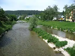 The Vöckla in Vöcklabruck | |
| Location | |
| Country | Austria |
| State | Upper Austria |
| Physical characteristics | |
| Source | |
| • location | northeast of the Mondsee |
| • coordinates | 47.8814°N 13.3641°E |
| Mouth | |
• location | in Vöcklabruck into the Ager |
• coordinates | 48°00′04″N 13°40′18″E |
| Length | 47.2 km (29.3 mi) [1] |
| Basin features | |
| Progression | Ager→ Traun→ Danube→ Black Sea |
The Vöckla is a river in Upper Austria.
References
- DORIS Atlas (Upper Austria)
- Google (9 February 2020). "Vöckla source" (Map). Google Maps. Google. Retrieved 9 February 2020.
- Google (9 February 2020). "Dürre Ager mouth" (Map). Google Maps. Google. Retrieved 9 February 2020.
- Google (9 February 2020). "Vöckla mouth" (Map). Google Maps. Google. Retrieved 9 February 2020.
This article is issued from Wikipedia. The text is licensed under Creative Commons - Attribution - Sharealike. Additional terms may apply for the media files.