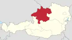
Upper Austria
Upper Austria (German: Oberösterreich [ˈoːbɐˌʔøːstɐʁaɪ̯ç] (![]() listen); Austro-Bavarian: Obaestareich; Czech: Horní Rakousy) is one of the nine states or Bundesländer of Austria. Its capital is Linz. Upper Austria borders on Germany and the Czech Republic, as well as on the other Austrian states of Lower Austria, Styria, and Salzburg. With an area of 11,982 km2 (4,626 sq mi) and 1.49 million inhabitants, Upper Austria is the fourth-largest Austrian state by land area and the third-largest by population.
listen); Austro-Bavarian: Obaestareich; Czech: Horní Rakousy) is one of the nine states or Bundesländer of Austria. Its capital is Linz. Upper Austria borders on Germany and the Czech Republic, as well as on the other Austrian states of Lower Austria, Styria, and Salzburg. With an area of 11,982 km2 (4,626 sq mi) and 1.49 million inhabitants, Upper Austria is the fourth-largest Austrian state by land area and the third-largest by population.
Upper Austria
Oberösterreich | |
|---|---|
 Flag  Coat of arms | |
 | |
| Country | |
| Capital | Linz |
| Government | |
| • Governor | Thomas Stelzer (ÖVP) |
| • Deputy Governors |
|
| Area | |
| • Total | 11,981.92 km2 (4,626.25 sq mi) |
| Population (1 January 2020) | |
| • Total | 1,490,392 |
| • Density | 120/km2 (320/sq mi) |
| Time zone | UTC+1 (CET) |
| • Summer (DST) | UTC+2 (CEST) |
| ISO 3166 code | AT-4 |
| HDI (2017) | 0.898[1] very high · 5th |
| NUTS Region | AT3 |
| Votes in Bundesrat | 12 (of 62) |
| Website | www |
History
Origins
For a long period of the Middle Ages, much of what would become Upper Austria constituted Traungau, a region of the Duchy of Bavaria, while the area around Steyr was part of the Duchy of Styria (which derives its name from the city). In the mid 13th century it became known as the Principality above the Enns River (Fürstentum ob der Enns), this name being first recorded in 1264. (At the time, the term "Upper Austria" also included Tyrol and various scattered Habsburg possessions in South Germany.)
Early Modern era
In 1490, the area was given a measure of independence within the Holy Roman Empire, with the status of a principality. By 1550, there was a Protestant majority. In 1564, Upper Austria, together with Lower Austria and the Bohemian territories, fell under Holy Roman Emperor Maximilian II.
At the start of the 17th century, the counter-reformation was instituted under Emperor Rudolf II and his successor Matthias. After a military campaign, the area was under the control of Bavaria for some years in the early 17th century.
The Innviertel was ceded from the Electorate of Bavaria to Upper Austria in the Treaty of Teschen in 1779. During the Napoleonic Wars, Upper Austria was occupied by the French army on more than one occasion.
20th century
In 1918, after the collapse of Austria-Hungary, the name Oberösterreich was used to describe the province of the new Austria. After Austria was annexed by Adolf Hitler, the Nazi dictator, who had been born in the Upper Austrian town of Braunau am Inn and raised in Upper Austria, Upper Austria became Reichsgau Oberdonau, although this also included the southern part of the Sudetenland, annexed from Czechoslovakia, and a small part of Styria. In 1945, Upper Austria was partitioned between the American zone to the south and the Soviet zone to the north.
Today, Upper Austria is Austria's leading industrial region. As of 2009, it accounted for approximately a quarter of the country's exports.[2]
Economy
The Gross domestic product (GDP) of the state was 65.9 billion € in 2018, accounting for 17.1% of the Austria's economic output. GDP per capita adjusted for purchasing power was 39,500 € or 131% of the EU27 average in the same year.[3]
Administrative divisions
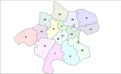
Administratively, the state is divided into 15 districts (Bezirke), three Statutarstädte and 442 municipalities.
.JPG.webp)
Districts
Historical regions
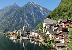
Historically, Upper Austria was traditionally divided into four viertel or regions: Hausruckviertel, Innviertel, Mühlviertel, and Traunviertel.
Today these do not exist as administrative regions, but are often still spoken about and referred to: for instance, as the term for the local language dialect (e.g. Innviertlerisch), as the term for the local regional cuisine (e.g. Innviertler Küche), or in regional tourism campaigns (e.g. s'Innviertel).
See also
Notes
- "Sub-national HDI - Area Database - Global Data Lab". hdi.globaldatalab.org. Retrieved 2018-09-13.
- Upper Austria Technology and Marketing Company. "Upper Austria in figures". Retrieved 2014-05-03.
- "Regional GDP per capita ranged from 30% to 263% of the EU average in 2018". Eurostat.
External links
| Wikimedia Commons has media related to Upper Austria. |
| Wikisource has the text of the 1911 Encyclopædia Britannica article Austria, Upper. |
| Wikivoyage has a travel guide for Upper Austria. |
- (in German) Upper Austria official website
| Authority control |
|---|