Vadfoss
Vadfoss is a village in Kragerø municipality of Norway, located on the Kammerfoss River (alternate name: Kragerø River) midway between Helle to the east and Sannidal to the west. It is also close to the city of Kragerø, located roughly 5 km (3.1 mi) to the northwest. Since the village is so small and close to Helle, Statistics Norway considers them a single village Vadfoss/Helle with a combined population of 1,556.[1]
Vadfoss
Vafoss, Vadfoss/Helle | |
|---|---|
Village | |
 | |
 Vadfoss Location of Helle in Telemark  Vadfoss Vadfoss (Norway) | |
| Coordinates: 58°53′33.5″N 9°20′28″E | |
| Country | Norway |
| Region | Eastern Norway |
| County | Telemark |
| District | Vestmar |
| Municipality | Kragerø |
| Area | |
| • Total | 1.59 km2 (0.61 sq mi) |
| Population (2012)[1] | |
| • Total | 1,556 |
| • Density | 979/km2 (2,540/sq mi) |
| Time zone | UTC+01:00 (CET) |
| • Summer (DST) | UTC+02:00 (CEST) |
| Post Code | 3790 Helle |
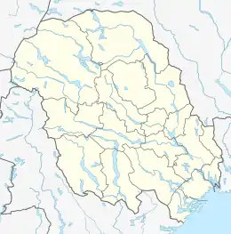
Location
The river beside Vadfoss has no clear name due to the fact that it changes names several times along its length, but it is often referred to as the Kragerø watershed estuary or sometimes the Kragerø River (see the Gallery section for a graphical representation of its many names). In general terms, it is the river stemming from the lake Toke and leading out to the Kilsfjord. The first 5.5 km (3.4 mi) of the river that spans from Toke to the lake Farsjø is referred to as the Lundereid River. After that, it is called Fossene and then Tisjø until it reaches Tveitreid Lake. The section flowing from Tveitreid Lake is referred to as Vadfoss River up until it hits the Vafoss Dam. After that it is called Kammerfoss River all the way until it reaches Kilsfjord.
The main road serving Vadfoss is part of Fylkesvei 38, which extends north across Kammerfoss River to connect onto the E18 and southwest towards Kragerø. This road is also considered part of Fylkesvei 363, which splits off from the 38 in the north to go west towards Sannidal and in the south to go east towards Helle. In 2008, the 680 m (2,230 ft) long Vadfoss Tunnel was built just north of the Vadfoss Bridge on the main road, eliminating the need to take the longer and more residential Sannidalsveien.[2]
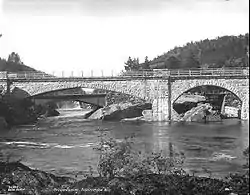
Vadfoss was a train station on the now defunct Kragerø Line that transported primarily lumber and passengers. In 1989, the whole line south of Sannidal Station was torn up in order to make way for the new main road. Elements of the rail line still remain however, including the bridge across the river and the original station building from 1927, which is now used as a visitor center and bus depot.
Industry
Though many people live in Vadfoss, the nearby river and the dam in the north of the village have made it a popular area for industry. Vafoss Dam was built in the late 1800s to power the Vafos AS pulp mill, the second such dam built on the river. In 1954, the Vafoss Power Plant was put into operation on the dam by Skagerak Kraft, with the provision that one of its turbines would be used to power the pulp mill. The hydroelectric plant uses two Francis turbines to convert a 13 m (43 ft) water drop into 15 gigawatt-hours (54,000 gigajoules) of power annually.[3] As promised, one turbine directly powers the pulp mill, and Vafos AS is still in operation, producing about 80,000 metric tonnes of pulp yearly from locally sourced spruce logs.
Vafoss Power Plant is just one of seven hydroelectric plants in the Kragerø watershed, and one of five on the Kragerø River. Other nearby plants are the Langfoss Power Plant, which lies less than half a mile up the river, and Kammerfoss Power Plant to the south of Vadfoss. The five plants on the Kragerø River combined with the two others on Suvdøla in Drangedal produce an average of 123 GWh (440,000 GJ) of electricity per year.
Gallery
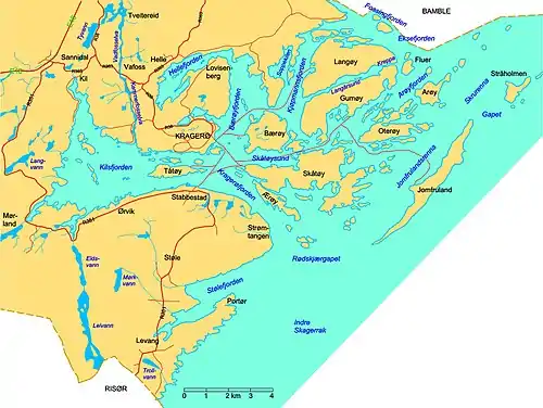 A closeup of the Kragerø archipelago. Vadfoss is on the upper right of this map using the alternate spelling of "Vafoss."
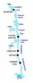 A map of the Kragerø watershed estuary, showing the names of the numerous bodies of water. The black squares represent power plants on the river.
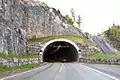 A view of the Vadfoss Tunnel from the north.
Photo: Peter Fiskerstrand
References
- Statistics Norway (2012). "Urban settlements. Population and area, by municipality. 1 Jan 2012". Archived from the original on 20 November 2012. Retrieved 16 Jan 2013. Cite journal requires
|journal=(help) - Selås, Elin Frisch (11 Jan 2008). "Milestone for the main road" (in Norwegian). Kragerø Blad Vestmar. Retrieved 16 Jan 2013.
- "Waterways and Regulation" (in Norwegian). Kragerø Watershed Landowners Association. 2012. Retrieved 16 Jan 2013.