Vadose zone
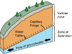
The vadose zone, also termed the unsaturated zone, is the part of Earth between the land surface and the top of the phreatic zone, the position at which the groundwater (the water in the soil's pores) is at atmospheric pressure ("vadose" is from the Latin word for "shallow"). Hence, the vadose zone extends from the top of the ground surface to the water table.

Water in the vadose zone has a pressure head less than atmospheric pressure, and is retained by a combination of adhesion (funiculary groundwater), and capillary action (capillary groundwater). If the vadose zone envelops soil, the water contained therein is termed soil moisture. In fine grained soils, capillary action can cause the pores of the soil to be fully saturated above the water table at a pressure less than atmospheric. The vadose zone does not include the area that is still saturated above the water table, often referred to as the capillary fringe. [1]
Movement of water within the vadose zone is studied within soil physics and hydrology, particularly hydrogeology, and is of importance to agriculture, contaminant transport, and flood control. The Richards equation is often used to mathematically describe the flow of water, which is based partially on Darcy's law. Groundwater recharge, which is an important process that refills aquifers, generally occurs through the vadose zone from precipitation.
In hydrology

The vadose zone is the undersaturated portion of the subsurface that lies above the groundwater table. The soil and rock in the vadose zone are not fully saturated with water; that is, the pores within them contain air as well as water. In some places, the vadose zone is absent, as is common where there are lakes and marshes, and in some places, it is hundreds of meters thick, as is common in arid regions.[2]
Unlike the aquifers of the underlying water-saturated phreatic zone, the vadose zone is not a source of readily available water for human consumption. It is of great importance in providing water and nutrients that are vital to the biosphere, however, and it is intensively used for the cultivation of plants, construction of buildings, and disposal of waste.[2]
The vadose zone is often the main factor controlling water movement from the land surface to the aquifer. Thus it strongly affects the rate of aquifer recharge and is critical for the use and management of groundwater. Flow rates and chemical reactions in the vadose zone also control whether, where, and how fast contaminants enter groundwater supplies. Understanding of vadose-zone processes is therefore crucial in determining the amount and quality of groundwater that is available for human use.[2]
In speleology
In speleology, cave passages formed in the vadose zone tend to be canyon-like in shape, as the water dissolves bedrock on the floor of the passage.[3] Passages created in completely water-filled conditions are called phreatic passages and tend to be circular in cross-section.[4]
See also
| Look up vadose in Wiktionary, the free dictionary. |
- Aquifer – Underground layer of water-bearing permeable rock
- Epiphreatic zone – The zone between the vadose zone above and phreatic zone below
- Groundwater – Water located beneath the ground surface
- Water retention curve
References
- Freeze, R.A. and Cherry, J.A., 1979. Groundwater. Englewood Cliffs, NJ, Printice-Hall Inc., 604 p.
- US Geological Survey, Office of Groundwater
- Caves & Caving: Glossary
- New Mexico: Bureau of Mines & Mining Bulletin 117 (Part I: Discussion of Deposits and Events)
Further reading
- "Unsaturated Zone". USGS. Retrieved 2014-05-01.
- "Aquifers". USGS. Retrieved 2014-05-01.
- "Unsaturated Zone Definitions Page". USGS. Retrieved 2006-07-01.
- "Unsaturated Zone Flow: Definitions and Details". USGS. Archived from the original on 2006-05-24. Retrieved 2006-07-01.
- Wilson, L.G.; Everett, Lorne G.; Cullen, Stephen J., eds. (1994). Handbook of Vadose Zone Characterization & Monitoring. CRC Press. ISBN 0873716108.
