Vaige
The Vaige (French: la Vaige) is a 53.6 km (33.3 mi) long river in the Mayenne and Sarthe departments in western France.[1]
| Vaige | |
|---|---|
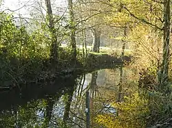 Vaige river at the south of La Bazouge-de-Chemeré in winter | |
| Location | |
| Country | France |
| Physical characteristics | |
| Source | |
| • location | Saint-Léger |
| • coordinates | 48°04′52″N 00°28′15″W |
| • elevation | 112 m (367 ft) |
| Mouth | |
• location | Sarthe |
• coordinates | 47°50′15″N 00°19′55″W |
• elevation | 24 m (79 ft) |
| Length | 53.6 km (33.3 mi) |
| Basin size | 233 km2 (90 sq mi) |
| Discharge | |
| • average | 1.48 m3/s (52 cu ft/s) |
| Basin features | |
| Progression | Sarthe→ Maine→ Loire→ Atlantic Ocean |
This list is ordered from source to mouth:
- In Mayenne, the Vaige has its source in Saint-Léger then waters the following villages : Vaiges, Saint-Georges-le-Fléchard, La Bazouge-de-Chemeré, La Cropte, Saint-Denis-du-Maine, Préaux, Ballée, Beaumont-Pied-de-Bœuf,
- Then the Vaige séparates Mayenne (Saint-Loup-du-Dorat) from Sarthe (Auvers-le-Hamon),
- Only in Mayenne the Vaige waters Bouessay,
- Entering the Sarthe department, the Vaige avoid the Sablé-sur-Sarthe town and flows in the Sarthe (right tributary)
low water and flood
Very often the river uses to dry at the end of summer and the beginning of autumn, so fishes and river mussels die but kingfishers may fly away.
 the Vaige dried at the south of the Bazouge-de-Chemeré on September 17, 2005
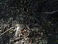 Died fishes in the dried river on 2005
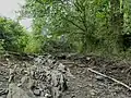 the Vaige dried at the south of the Bazouge-de-Chemeré on June 24, 2017
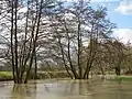 Flood at the south of the Bazouge-de-Chemeré on February 28, 2010
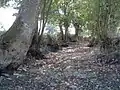
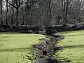 The Chemerette stream passes through an old path before flowing in Vaige river.
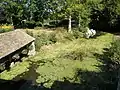 Wash-house in La Cropte
Notes
- This article is based on the fr:Vaige from the French Wikipedia, consulted on March 22, 2009. and illustrated on October 10, 2019
References
This article is issued from Wikipedia. The text is licensed under Creative Commons - Attribution - Sharealike. Additional terms may apply for the media files.
