Valley Trail (Grand Teton National Park)
The Valley Trail is a 40-mile (64 km) long hiking trail in Grand Teton National Park in the U.S. state of Wyoming.[1] Though the trail can be accessed at numerous trailheads in Grand Teton National Park, the southern terminus is near Teton Village, Wyoming, just outside the park. Heading north from Teton Village, the Valley Trail flanks the base of the Teton Range and skirts the shores of Phelps, Taggart, Bradley, Jenny, String, Leigh, Bearpaw and Trapper Lakes. Along its 40-mile (64 km) length, it is sometimes known by other names such as the Jenny Lake Trail or the String Lake Trail.[2]
| Valley Trail | |
|---|---|
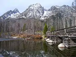 The Valley Trail crosses a footbridge at String Lake | |
| Length | 40 mi (64 km) |
| Location | Jackson Hole |
| Trailheads | Teton Village |
| Use | Hiking |
| Elevation | |
| Elevation change | Approximate gain of 1,100 ft (340 m) |
| Highest point | Near Phelps Lake, 7,400 ft (2,300 m) |
| Lowest point | Teton Village, 6,300 ft (1,900 m) |
| Hiking details | |
| Trail difficulty | Moderate-Strenuous |
| Season | Spring to Fall |
| Sights | Teton Range Numerous Lakes |
| Hazards | Severe weather |
References
- "Lupine Meadows Trailhead" (pdf). National Park Service. Retrieved 2012-05-19.
- Moose, WY (Map). Topoquest (USGS Quads). Retrieved 2012-05-12.
- "Valley Trail". Geographic Names Information System. United States Geological Survey. Retrieved 2012-05-12.
This article is issued from Wikipedia. The text is licensed under Creative Commons - Attribution - Sharealike. Additional terms may apply for the media files.