Ventura River Parkway Trail
The Ventura River Parkway Trail is a southern California rail trail roughly paralleling California State Route 33 for 16.5 mi (26.6 km) from Ventura to Ojai. It follows the route of the former Ventura and Ojai Valley Railroad abandoned between 1969 and 1995.
| Ventura River Parkway Trail | |
|---|---|
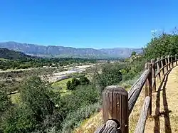 Ventura River as viewed from the Devils Gulch fill on the Ojai Valley Trail | |
| Length | 16.5 miles (26.6 km) |
| Location | Ventura County, California, United States |
| Use | cycling, pedestrians, equestrians, on-leash pet walking |
| Elevation | |
| Elevation change | 934 ft (285 m) |
| Highest point | 969 ft (295 m) |
| Lowest point | 35 ft (11 m) |
| Grade | 2% |
| Cycling details | |
| Surface | asphalt concrete and unpaved |
Ventura River Parkway Trail | |||||||||||||||||||||||||||||||||||||||||||||||||||||||||||||||||||||||||||||||||||||||||||||||||||||||||||||||||||||||||||||||||||||||||||||||||||
|---|---|---|---|---|---|---|---|---|---|---|---|---|---|---|---|---|---|---|---|---|---|---|---|---|---|---|---|---|---|---|---|---|---|---|---|---|---|---|---|---|---|---|---|---|---|---|---|---|---|---|---|---|---|---|---|---|---|---|---|---|---|---|---|---|---|---|---|---|---|---|---|---|---|---|---|---|---|---|---|---|---|---|---|---|---|---|---|---|---|---|---|---|---|---|---|---|---|---|---|---|---|---|---|---|---|---|---|---|---|---|---|---|---|---|---|---|---|---|---|---|---|---|---|---|---|---|---|---|---|---|---|---|---|---|---|---|---|---|---|---|---|---|---|---|---|---|---|
| |||||||||||||||||||||||||||||||||||||||||||||||||||||||||||||||||||||||||||||||||||||||||||||||||||||||||||||||||||||||||||||||||||||||||||||||||||
Route
The southern end of the trail, known as the Ventura River Trail, follows the east side of the Ojai Freeway about 3 mi (4.8 km) through the industrialized Ventura Oil Field before crossing under the freeway adjacent to Crooked Palm Road.[1] The trail then follows the west side of highway 33 another 3 mi (4.8 km) through the former Canet oil refinery and the Ventura water purification plant to Foster Park at the south edge of Casitas Springs.[2] The trail known as the Ojai Valley Trail diverges from the highway along the west side of Casitas Springs into riparian woodlands following the east bank of the Ventura River as the highway climbs to Oak View. From 2 mi (3.2 km) of two percent uphill grade, the trail emerges from the woodlands along the west side of Oak View to rejoin the highway from a high fill across Devils Gulch overlooking the river. The trail closely follows the west side of highway 33 north of Oak View about 4 mi (6.4 km) until crossing the highway at the intersection with California State Route 150 into downtown Ojai. The northern end of the trail runs more than a mile easterly from the intersection through Ojai a few blocks south of highway 150.[3]
Facilities
Most of the trail has asphalt concrete pavement for bicyclists, hikers, joggers, and dog-walkers using leashes. Some portions of the trail have a fence separating a parallel unpaved equestrian path. There are numerous public access points along the trail with parking lots in Foster Park on the south side of Casitas Springs and near the intersection of Main and Peking Streets in Ventura.[2]
_at_Foster_Park.jpg.webp) Trail thru Foster Park has both the unpaved equestrian path on the left and paved bicycle path on the right
Trail thru Foster Park has both the unpaved equestrian path on the left and paved bicycle path on the right_Trail_map_sign.jpg.webp) Trail sign map of the trail north of Foster Park
Trail sign map of the trail north of Foster Park_at_Hermosa_Road.jpg.webp) Trail crossing Hermosa Road illustrates typical trail proximity to highway 33 (on left) between Oak View and Ojai
Trail crossing Hermosa Road illustrates typical trail proximity to highway 33 (on left) between Oak View and Ojai
Sources
- "Ventura River Trail". TrailLink. Rails-to-Trails Conservancy. Retrieved 16 May 2020.
- "Ventura River Parkway Trail". NRT Database. American Trails. Retrieved 16 May 2020.
- "Ojai Valley Trail". TrailLink. Rails-to-Trails Conservancy. Retrieved 16 May 2020.