Vlagtwedde
Vlagtwedde (Dutch pronunciation: [ˈvlɑxˌtʋɛdə] (![]() listen)) is a village in the very southeast of Groningen province in the northeastern Netherlands. It lies on the Dutch border with the German state of Lower Saxony to the east.
listen)) is a village in the very southeast of Groningen province in the northeastern Netherlands. It lies on the Dutch border with the German state of Lower Saxony to the east.
Vlagtwedde | |
|---|---|
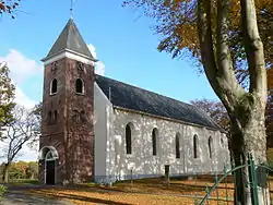 Protestant Church in Vlagtwedde in 2007 | |
.svg.png.webp) Location in Groningen | |
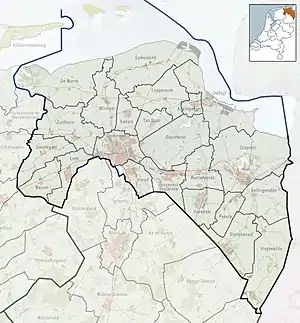 Vlagtwedde Location in the province of Groningen in the Netherlands | |
| Coordinates: 52°57′N 7°9′E | |
| Country | Netherlands |
| Province | Groningen |
| Municipality | Westerwolde |
| Established | December 1811 |
| Disestablished | 1 January 2018 |
| Area | |
| • Total | 170.55 km2 (65.85 sq mi) |
| • Land | 167.62 km2 (64.72 sq mi) |
| • Water | 2.93 km2 (1.13 sq mi) |
| Elevation | 8 m (26 ft) |
| Demonym(s) | Vlagtwedder |
| Time zone | UTC+1 (CET) |
| • Summer (DST) | UTC+2 (CEST) |
| Postcode | 9540–9564 |
| Area code | 0599 |
| Website | www |
History
The municipality of Vlagtwedde was created in December 1811.[3]
On 1 January 2018, the municipality of Vlagtwedde was merged with Bellingwedde to form the new municipality of Westerwolde.[4]
Geography
The population centres in the municipality of Vlagtwedde were:
Abeltjeshuis, Bakovensmee, Barnflair, Borgertange, Borgerveld, Bourtange, Burgemeester Beinsdorp, De Bruil, Ellersinghuizen, Hanetange, Harpel, Hasseberg, Hebrecht, 't Heem, Jipsingboermussel, Jipsingboertange, Jipsinghuizen, Lammerweg, Laude, Lauderbeetse, Laudermarke, Lauderzwarteveen, Leemdobben, Maten, Munnekemoer, Over de Dijk, Overdiep, Pallert, Plaggenborg, Poldert, Renneborg, Rhederveld, Rijsdam, Roelage, 't Schot, Sellingen, Sellingerbeetse, Sellingerzwarteveen, Slegge, Stakenborg, Stobben, Ter Apel, Ter Apelkanaal, Ter Borg, Ter Haar, Ter Walslage, Ter Wisch, Veele, Veerste Veldhuis, Vlagtwedde, Vlagtwedder-Barlage, Vlagtwedder-Veldhuis, Weende, Weenderveld, Weite, Wessingtange, Wollingboermarke, Wollinghuizen, Zandberg and Zuidveld.
Because of the large number of official centres, the municipality had five postal codes:
- 9541 Vlagtwedde
- 9545 Bourtange
- 9551 Sellingen
- 9561 Ter Apel
- 9563 Ter Apelkanaal
All 60 villages and hamlets in the municipality received their own town sign in 2008.
Politics
The city council of Vlagtwedde had 17 seats. The table below gives political party and seat counts since 1998.
| City council seats | |||||||||||||||
|---|---|---|---|---|---|---|---|---|---|---|---|---|---|---|---|
| Party | 1998 | 2002 | 2006 | 2010 | |||||||||||
| PvdA | 5 | 4 | 6 | 4 | |||||||||||
| CDA | 5 | 5 | 3 | 3 | |||||||||||
| Local municipal interests | 2 | 3 | 4 | 5 | |||||||||||
| VVD | 3 | 3 | 2 | 2 | |||||||||||
| GreenLeft | 1 | 1 | 1 | 2 | |||||||||||
| ChristianUnion | 1 | 1 | 1 | 1 | |||||||||||
| Totaal | 17 | 17 | 17 | 17 | |||||||||||
Public transport
Vlagtwedde is served by several bus lines:
- line 14: Stadskanaal-Alteveer-Vlagtwedde-Veele-Blijham-Winschoten
- line 42: Emmen-Emmer Compascuum-Ter Apel-Sellingen-Vlagtwedde
- line 72: Vlagtwedde-Bourtange
- line 73: Emmen-Nieuw Weerdinge-Ter Apel-Ter Apelkanaal-Zandberg-Musselkanaal-Stadskanaal-Hoogezand-Groningen
- buurtbus (community volunteer-driven bus) 92: Stadskanaal-Mussel-Jipsingbourtange-Jipsinghuizen-Sellingen
References
- "Kerncijfers wijken en buurten 2020" [Key figures for neighbourhoods 2020]. StatLine (in Dutch). CBS. 24 July 2020. Retrieved 19 September 2020.
- "Postcodetool for 9551AB". Actueel Hoogtebestand Nederland (in Dutch). Het Waterschapshuis. Retrieved 5 February 2014.
- "Geschiedenis" (in Dutch), Municipality of Vlagwedde. Retrieved 28 December 2017.
- Marcel Looden, "Westerwolde: 40 mensen tekort" (in Dutch), Dagblad van het Noorden, 2017. Retrieved 28 December 2017.
External links
| Wikimedia Commons has media related to Vlagtwedde. |
Places adjacent to Vlagtwedde | |
|---|---|
| Authority control |
|---|
