Vogtei, Thuringia
Vogtei is a municipality in the Unstrut-Hainich-Kreis district of Thuringia, Germany. It was formed on 31 December 2012 by the merger of the former municipalities Langula, Niederdorla and Oberdorla. The closest city ("Stadt"), and the only one that it borders, is Mühlhausen, which lies at its northern perimeter.
Vogtei | |
|---|---|
Location of Vogtei within Unstrut-Hainich-Kreis district 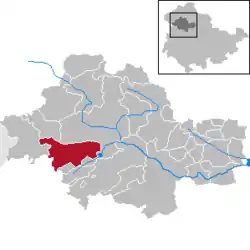 | |
 Vogtei 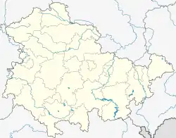 Vogtei | |
| Coordinates: 51°9′25″N 10°25′40″E | |
| Country | Germany |
| State | Thuringia |
| District | Unstrut-Hainich-Kreis |
| Area | |
| • Total | 49.51 km2 (19.12 sq mi) |
| Elevation | 227 m (745 ft) |
| Population (2019-12-31)[1] | |
| • Total | 4,353 |
| • Density | 88/km2 (230/sq mi) |
| Time zone | UTC+01:00 (CET) |
| • Summer (DST) | UTC+02:00 (CEST) |
| Postal codes | 99986 |
| Dialling codes | 03601 |
| Vehicle registration | UH |
Geographical center
The widely accepted geographical center of Germany lies in Vogtei, more specifically in its Niederdorla section, where there is a plaque at 51°9′48.15″N 10°26′51.66″E with the coordinates as calculated by technical experts.
See also
References
- "Bevölkerung der Gemeinden, erfüllenden Gemeinden und Verwaltungsgemeinschaften in Thüringen Gebietsstand: 31.12.2019". Thüringer Landesamt für Statistik (in German). August 2020.
| Authority control |
|---|
This article is issued from Wikipedia. The text is licensed under Creative Commons - Attribution - Sharealike. Additional terms may apply for the media files.
