Vstrechny, Chukotka Autonomous Okrug
Vstrechny (Russian: Встречный) is an inhabited locality (an urban-type settlement) in Bilibinsky District of Chukotka Autonomous Okrug, Russia, located about 25 kilometers (16 mi) ENE of Bilibino. Population: 13 (2002 Census),[2] 1,641 (1989 Census).[7] The 2002 census data shows the population to consist of 12 males and 1 female,[2] though this had fallen to only 7 by 2005 according to an environmental impact report prepared on the Kupol mining project.[4]
Vstrechny
Встречный | |
|---|---|
Urban-type settlement[1] (abolished) | |
Location of Vstrechny 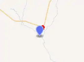
| |
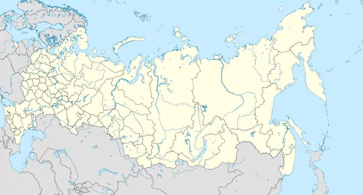 Vstrechny Location of Vstrechny 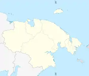 Vstrechny Vstrechny (Chukotka Autonomous Okrug) | |
| Coordinates: 67°57′00″N 165°36′00″E | |
| Country | Russia |
| Federal subject | Chukotka Autonomous Okrug[2] |
| Administrative district | Bilibinsky District[2] |
| Abolished | 1998[3] |
| Population | |
| • Estimate (June 2005)[4] | 7 |
| Time zone | UTC+12 (MSK+9 |
| Postal code(s)[6] | 689450 |
| OKTMO ID | 77609701912 |
History
Soviet period
The settlement, located on the right hand bank of the Enmynveyem River, was originally created like many throughout this part of Chukotka following the establishment of a mine nearby (Initially called Vstrechny itself) in 1961 to extract gold from the Enmynveyem to house the workers. Two years later however, the mine's name was changed to "45 Years of the Komsomol" (Russian: 45 лет ВЛКСМ) In 1965, the settlement received the status of urban-type settlement.
Post-Soviet period
When the mines were deemed to be uneconomic, the settlement was abandoned and mostly depopulated by 1996.[8] In 2004, a road was completed linking the settlement with the regional centre, giving hope that the settlement can continue.[8] However, as of 2009, Vstrechny is included in the list of settlements currently in the process of being liquidated.[1]
Population
The mines were declared unprofitable and that there was no possibility of developing any other form of economy in 1999 and the settlement was closed along with a number of others in Chukotka.[3] The Russian government guaranteed funds to transport non-working pensioners and the unemployed in liquidated settlements including Baranikha from Chukotka to other parts of Russia.[3] The Ministry of railways was obliged to lease containers for the transportation of the migrants' goods to the Chukotkan administration and ensure that they were delivered to the various settlements.[3] The population table below shows the impact on the settlement as a result of the closure of the mines.
| 1970 | 1979 | 1989 | 2002 | 2005 |
|---|---|---|---|---|
| 1819[9] | 1572[10] | 1641[11] | 13[12] | 7[4] |
Transport
Vstrechny is linked to Bilibino and Keperveyem by a small road network that also links the now abandoned settlements of Bezmyanniy and Karalvaam.[13] There is also a small network of roads within the settlement including:[14]
- Улица Коммунальная (Ulitsa Kommumalnaya, lit. Communal Street)
- Улица Космонавтов (Ulitsa Kosmonavtov, lit. Cosmonaut Street)
- Улица Ленина (Ulitsa Lenina, lit. Lenin Street)
- Улица Мира (Ulitsa Mira, lit. World Street)
- Улица Центральная (Ulitsa Tsentralnaya, lit. Central Street)
- Улица Юбилейная (Ulitsa Yubileinaya, lit. Jubilee Street)
Climate
Vstrechny has a Continental Subarctic or Boreal (taiga) climate (Dfc).[15]
| Climate data for Vstrechny | |||||||||||||
|---|---|---|---|---|---|---|---|---|---|---|---|---|---|
| Month | Jan | Feb | Mar | Apr | May | Jun | Jul | Aug | Sep | Oct | Nov | Dec | Year |
| Record high °C (°F) | 0 (32) |
3 (37) |
1.8 (35.2) |
8.3 (46.9) |
23.2 (73.8) |
32 (90) |
35.1 (95.2) |
29.9 (85.8) |
21 (70) |
8 (46) |
3.2 (37.8) |
1.9 (35.4) |
35.1 (95.2) |
| Average high °C (°F) | −27.6 (−17.7) |
−26.8 (−16.2) |
−17.5 (0.5) |
−6.8 (19.8) |
5.9 (42.6) |
16 (61) |
16.8 (62.2) |
13.9 (57.0) |
5.6 (42.1) |
−8 (18) |
−22.3 (−8.1) |
−27.5 (−17.5) |
−7.5 (18.5) |
| Average low °C (°F) | −32.2 (−26.0) |
−32.7 (−26.9) |
−28.7 (−19.7) |
−18.5 (−1.3) |
−3.2 (26.2) |
5.2 (41.4) |
6.7 (44.1) |
3.4 (38.1) |
−1.8 (28.8) |
−14.4 (6.1) |
−27.3 (−17.1) |
−32.4 (−26.3) |
−14.7 (5.5) |
| Record low °C (°F) | −58 (−72) |
−54 (−65) |
−50.3 (−58.5) |
−44 (−47) |
−23.5 (−10.3) |
−5.4 (22.3) |
−2.3 (27.9) |
−8.2 (17.2) |
−15 (5) |
−37 (−35) |
−47 (−53) |
−52 (−62) |
−58 (−72) |
| Average rainfall mm (inches) | 12 (0.5) |
9 (0.4) |
3 (0.1) |
6 (0.2) |
6 (0.2) |
18 (0.7) |
42 (1.7) |
30 (1.2) |
21 (0.8) |
18 (0.7) |
12 (0.5) |
18 (0.7) |
195 (7.7) |
| Average snowy days | 25 | 19 | 14 | 10 | 7 | 1 | 0 | 0 | 9 | 20 | 18 | 21 | 144 |
| Source: [16] | |||||||||||||
References
Notes
- Law #33, Article 14.2
- Russian Federal State Statistics Service (21 May 2004). "Численность населения России, субъектов Российской Федерации в составе федеральных округов, районов, городских поселений, сельских населённых пунктов – районных центров и сельских населённых пунктов с населением 3 тысячи и более человек" [Population of Russia, Its Federal Districts, Federal Subjects, Districts, Urban Localities, Rural Localities—Administrative Centers, and Rural Localities with Population of Over 3,000] (XLS). Всероссийская перепись населения 2002 года [All-Russia Population Census of 2002] (in Russian).
- Постановление Правительства РФ от 2 февраля 1998 г. N 128 О мерах социальной защиты населения ликвидируемых поселков золотодобытчиков в Чукотском автономном округe (Russian Federation Government resolution dated February 2, 1998 No. 128 on measures of social protection of the population of liquidating estates gold miners in the Chukotka Autonomous Okrug "Russian Federation Government resolution dated February 2, 1998 No. 128 on measures of social protection of the population of liquidating estates gold miners in the Chukotka Autonomous Okrug).
- Bema Gold Corporation, p.89
- "Об исчислении времени". Официальный интернет-портал правовой информации (in Russian). 3 June 2011. Retrieved 19 January 2019.
- Почта России. Информационно-вычислительный центр ОАСУ РПО. (Russian Post). Поиск объектов почтовой связи (Postal Objects Search) (in Russian)
- "Всесоюзная перепись населения 1989 г. Численность наличного населения союзных и автономных республик, автономных областей и округов, краёв, областей, районов, городских поселений и сёл-райцентров" [All Union Population Census of 1989: Present Population of Union and Autonomous Republics, Autonomous Oblasts and Okrugs, Krais, Oblasts, Districts, Urban Settlements, and Villages Serving as District Administrative Centers]. Всесоюзная перепись населения 1989 года [All-Union Population Census of 1989] (in Russian). Институт демографии Национального исследовательского университета: Высшая школа экономики [Institute of Demography at the National Research University: Higher School of Economics]. 1989 – via Demoscope Weekly.
- Vstrechny at dead-cities.ru Archived 2009-02-25 at the Wayback Machine (in Russian)
- Перепись населения СССР 1970 года Archived 2012-03-23 at the Wayback Machine 1970 census of the Soviet Union
- Перепись населения СССР 1979 года Archived 2012-03-23 at the Wayback Machine 1979 census of the Soviet Union
- Всесоюзная перепись населения 1989 г. Численность городского населения РСФСР, ее территориальных единиц, городских поселений и городских районов по полу All-Union census, the constituent entities of the Russian Federation, in the federal districts, towns, rural settlements and regional centres with a population of more than 3,000.
- Численность населения России, субъектов Российской Федерации в составе федеральных округов, районов, городских поселений, сельских населённых пунктов – районных центров и сельских населённых пунктов с населением 3 тысячи и более человек
- Map r-57-58 Archived 2013-05-02 at the Wayback Machine at Vlasenko.net
- Vstrechny - Bilibinsky District at Pochtovik Mail Delivery Company
- McKnight and Hess, pp.232-5
- "Weather Averages for Vstrechny from meoweather.com". meoweather.com. Retrieved October 1, 2012.
Sources
- Bema Gold Corporation, Environmental Impact Assessment, Kupol Gold Project, Far East Russia June 2005.
- McKnight, Tom L; Hess, Darrel (2000). "Climate Zones and Types". Physical Geography: A Landscape Appreciation. Upper Saddle River, NJ: Prentice Hall. ISBN 0-13-020263-0.
- Дума Чукотского автономного округа. Закон №33-ОЗ от 30 июня 1998 г. «Об административно-территориальном устройстве Чукотского автономного округа», в ред. Закона №55-ОЗ от 9 июня 2012 г. «О внесении изменений в Закон Чукотского автономного округа "Об административно-территориальном устройстве Чукотского автономного округа"». Вступил в силу по истечении десяти дней со дня его официального опубликования. Опубликован: "Ведомости", №7 (28), 14 мая 1999 г. (Duma of Chukotka Autonomous Okrug. Law #33-OZ of June 30, 1998 On the Administrative-Territorial Structure of Chukotka Autonomous Okrug, as amended by the Law #55-OZ of June 9, 2012 On Amending the Law of Chukotka Autonomous Okrug "On the Administrative-Territorial Structure of Chukotka Autonomous Okrug". Effective as of after ten days from the day of the official publication.). (in Russian)