Wörth an der Donau
Wörth an der Donau is a town in the district of Regensburg, in Bavaria, Germany. It is situated on the left bank of the Danube, 22 km east of Regensburg.
Wörth an der Donau | |
|---|---|
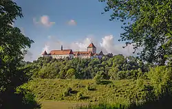 Wörth an der Donau Castle | |
 Coat of arms | |
Location of Wörth an der Donau within Regensburg district 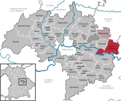 | |
 Wörth an der Donau  Wörth an der Donau | |
| Coordinates: 49°00′03″N 12°24′04″E | |
| Country | Germany |
| State | Bavaria |
| Admin. region | Upper Palatinate |
| District | Regensburg |
| Municipal assoc. | Wörth an der Donau |
| Government | |
| • Mayor | Anton Rothfischer |
| Area | |
| • Total | 52.34 km2 (20.21 sq mi) |
| Highest elevation | 630 m (2,070 ft) |
| Lowest elevation | 320 m (1,050 ft) |
| Population (2019-12-31)[1] | |
| • Total | 4,909 |
| • Density | 94/km2 (240/sq mi) |
| Time zone | UTC+01:00 (CET) |
| • Summer (DST) | UTC+02:00 (CEST) |
| Postal codes | 93084–93086 |
| Dialling codes | 09482 |
| Vehicle registration | R |
| Website | www.woerth-donau.de |
First mayors before 1945
First mention of a mayor: Ulrich Vorstl (1482)
- Franz Xaver Pittinger (1803-1808)
- Schottenloher
- Vilsmeier
- Kleebauer
- Max Joseph Scheglmann (1876 to 1888)
- Oetting (1888 to 1902)
- Johann Henfling (1902 to 1930)
- Karl Saller, last freely elected mayor (1930 to 1933)
- Alfons Lehle, NSDAP (April 1933 to August 1936)
- Paul Gottschall, NSDAP (August 1936 to October 1936)
- Friedrich Horkheimer, NSDAP (October 1936 to May 1945)
First mayor since 1945
- 1945 to 1946: Alois Schmelz (introduced by US-Army)
- 1946 to 1965: Johann Baumann (ÜWG)
- 1965 to 1973: Alfred Büchele (CSU)
- 1973 to 2002: Franz Beutl (CSU)
- Since 2002: Anton Rothfischer (ÜWG)
Official First Mayor
Anton Rothfischer (ÜWG) was elected mayor for the first time in the 2002 election. He was reelected in 2008 and 2014.
Sons and daughters of the town
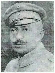
Otto Pittinger
- Otto Pittinger (1878-1926), medical councilor, politician and paramedical officer
- Johann Reichhart (1893-1972), executioner
- Ludwig Franz (1922-1990), politician (CSU) Member of Bundestag 1953-1976
- Franz Fuchs (born 1953), historian
References
- "Tabellenblatt "Daten 2", Statistischer Bericht A1200C 202041 Einwohnerzahlen der Gemeinden, Kreise und Regierungsbezirke". Bayerisches Landesamt für Statistik und Datenverarbeitung (in German). July 2020.
| Authority control |
|---|
This article is issued from Wikipedia. The text is licensed under Creative Commons - Attribution - Sharealike. Additional terms may apply for the media files.