Wadesboro Township, Anson County, North Carolina
Wadesboro Township, population 9,118, is one of eight townships in Anson County, North Carolina. Wadesboro Township is 73.15 square miles (189.5 km2)[1] in size and located in central Anson County. Wadesboro Township contains the town of Wadesboro, North Carolina.
Wadesboro Township, Anson County, North Carolina | |
|---|---|
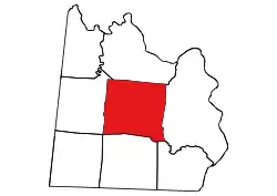 Location of Wadesboro Township in Anson County | |
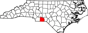 Location of Anson County in North Carolina | |
| Country | United States |
| State | North Carolina |
| County | Anson |
| Area | |
| • Total | 73.15 sq mi (189.46 km2) |
| Highest elevation [2] (high point at southwest end of township) | 602 ft (183 m) |
| Lowest elevation [2] (Goulds Fork, where it flows north out of the township) | 218 ft (66 m) |
| Population (2010) | |
| • Total | 9,118[3] |
| • Density | 124.65/sq mi (48.13/km2) |
| Time zone | UTC-4 (EST) |
| • Summer (DST) | UTC-5 (EDT) |
| Area code(s) | 704 |
Geography
Wadesboro Township is drained by Brown Creek and its tributaries on the north and west. These tributaries include Pinch Gut Creek, Goulds Fork, Hurricane Creek, and Flat Fork. Goulds Fork has two tributaries, Culpepper Creek and Grindstone Branch. The northeast part of the township is drained by Cedar Creek. The southeast end is drained by Bailey Creek and its tributary Brush Fork and by North Fork Jones Creek and its tributary, Lampley Branch.[4]
Places adjacent to Wadesboro Township, Anson County, North Carolina | |
|---|---|
References
- "NC OneMap". www.nconemap.gov. State of North Carolina. Retrieved 14 October 2020.
- "The National Map - Service Endpoints". viewer.nationalmap.gov. US Geological Survey. Retrieved 18 October 2020.
- "US Census Bureau Populations". data.census.gov. US Census Bureau. Retrieved 18 October 2020.
- "North Carolina Flood Hazard Area Effective". www.nconemap.gov. State of North Carolina. Retrieved 17 October 2020.
Municipalities and communities of Anson County, North Carolina, United States | ||
|---|---|---|
| Towns | 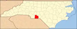 | |
| Unincorporated community | ||
| Ghost town | ||
| ||
This article is issued from Wikipedia. The text is licensed under Creative Commons - Attribution - Sharealike. Additional terms may apply for the media files.