Wadi Ham
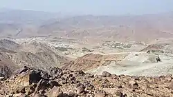
Wadi Ham is a wadi, a seasonal watercourse, in the Hajar Mountains of Fujairah and Ras Al Khaimah, United Arab Emirates.
| Wadi Ham | |
|---|---|
 | |
 | |
| Physical characteristics | |
| Mouth | |
• coordinates | 25°07′42.5″N 56°21′27.7″E |

The wadi runs from Masafi towards Fujairah City, until it reaches the Wadi Ham Dam [1] and the Gulf of Oman. The wadi is crossed by the Sharjah to Khor Fakkan road north of the village of Daftah, which is in Ras Al Khaimah and traditionally Mazari.[2] The Fujairah village of Al Bithnah and its strategically important fort, Al Bithnah Fort, is on the route.
The E 89 Sheikh Maktoum Bin Rashid Al Maktoum Road runs along the length of the wadi between Masafi and Fujairah City.[3] A proposed Etihad Rail line is also planned to run along this route.
At Masafi, the Wadi Ham joins the Wadi Abadilah, which runs down to the town of Dibba Al Hisn on the East Coast of the UAE, making Masafi the central point on a crescent-shaped, contiguous waterway that transects the Hajar Mountains.
Like many wadis in the Emirates, Wadi Ham has experienced salt water intrusions in the lower, coastal, part of the wadi, which has affected coastal agricultural systems.[4]
References
- "Natural Sites – Wadi Ham". www.fujairahtourism.ae. UAE: Fujairah Tourism & Antiquities Authority, Government of Fujairah. Retrieved 3 August 2018.
- Lancaster, William, 1938- (2011). Honour is in contentment : life before oil in Ras al-Khaimah (UAE) and some neighbouring regions. Lancaster, Fidelity. Berlin: De Gruyter. p. 191. ISBN 978-3-11-022340-8. OCLC 763160662.CS1 maint: multiple names: authors list (link)
- Fujairah Map, UAE: Fujairah Tourism & Antiquities Authority, 2018
- Mohsen Sherif; Ahmed Sefelnasr; A. M. Ebraheem; Akbar Javadi (January 2013). "Quantitative and Qualitative Assessment of Seawater Intrusion in Wadi Ham under Different Pumping Scenarios". Journal of Hydrologic Engineering. 19 (5): 855–866. doi:10.1061/(ASCE)HE.1943-5584.0000907.
| Settlements | |
|---|---|