Wainuiomata
Wainuiomata (/ˌwaɪnuːiˈɔːmɑːtə/) is a large suburb of Lower Hutt, in the Wellington Region of New Zealand's North Island. At the 2013 census, Wainuiomata had a population of 16,786.[2]
Wainuiomata | |
|---|---|
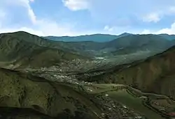 A view of Wainuiomata as seen from above Sunny Grove looking North. | |
| Nickname(s): Nappy Valley (historic)[1] | |
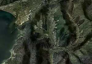
 Wainuiomata Wainuiomata within the Wellington metro area | |
| Coordinates: 41°15′41″S 174°57′3″E | |
| Country | New Zealand |
| Region | Wellington |
| Territorial authority | Lower Hutt City |
| Elevation | 86 m (282 ft) |
| Population (2013 census)[2] | |
| • Total | 16,786 |
| Postcode | 5014 |
| Website | www |
Origin of name
The word 'Wainui-o-mata' is a Māori name made up of the words Wai = water, Nui = big, O = of, and Mata – which could refer to a woman's name. The origins of the word are disputed, but one commonly accepted translation refers to the women who came over the Wainuiomata Hill to evade marauding tribes from the north, and who sat wailing by the stream after the slaughter of their menfolk. From this we have 'faces streaming with water' or 'tears' although it could equally refer to the large pools of water which lay over the swampy surface (face) of the northern end of the Valley, or the river itself which is known to flood the Wainui (Coast Road) valley.
The town is often abbreviated to Wainui by locals.[3]
History
Wainuiomata occupies a basin at the headwaters of the Wainuiomata River, between the eastern Hutt hills and the Orongorongo Range. There is little evidence of Māori occupation of the area before 1840, probably because it was covered in dense forest and large swamps. The 1855 Wairarapa earthquake raised these swamps and encouraged European settlement. The earliest settlements grew up around the river, where timber mills supplied the Wellington region when the demand was great in the 1850s and '60s. Today this area is known as "The Village" or "Homedale". The isolated location of Wainuiomata proved a problem for early settlers. Narrow hill-routes into the settlement were the only access during the 1850s and 1860s. By the end of the 19th century there were two roads in the valley: Main Road and Fitzherbert Road (known locally as "Swamp Road").[4]
The town's economy in these early days largely depended on timber milling from the forests around the Wainuiomata River. In the 1850s Sir William Fitzherbert started a flax-milling business in the north of the valley,[5] but this proved economically unviable.
In 1866 the Methodist Wainuiomata Coast Road Church was built on land donated by settler Richard Prouse. The oldest Methodist Church and the third-oldest church in the Wellington Region, it was used for regular services until the congregation outgrew it and moved to the new St Stephens Church in 1957.
With the clearing of the forests, sheep- and dairy-farming became an important part of the local economy. The settlement started to grow in the 1920s.
In 1928 Wainui-o-Mata Development Limited formed for the purpose of developing the Wainuiomata Valley through the acquisition of 1,600 hectares (4,000 acres) of land, its subdivision and its sale as residential lots.[4] An important part of the project involved the construction of the Wainuiomata Tunnel linking the Hutt Valley and Wainuiomata Valley for improving access to the new settlement.[6] Construction of the tunnel commenced in 1932, but the Depression bought a halt to construction, with many investors in the company losing money.
After World War II ended in 1945, major growth occurred due to affordable housing developments attracting many young couples, which transformed Wainuiomata into a working-class community. This influx of young families earned the community the nickname of "Nappy Valley" in the 1950s.[1]
In April 2009 a Palmerston North motelier banned all Wainuiomata residents after a series of misdemeanours by visitors from there.[7]
The first series of the television production Seven Periods with Mr Gormsby was shot in the old Wainuiomata College with many local residents as cast members.[8]
Geography
Hills surround Wainuiomata on three sides. The topography reduces local wind-flow, resulting in lower minimum temperatures in winter and higher maximum temperatures in summer than in most other parts of Wellington and the Hutt Valley.
The Orongorongo Valley, accessed via the Wainuiomata Valley, features bush walks and native-forest scenery.
Government
Since 1989, Wainuiomata has been part of Lower Hutt City. The Wainuiomata ward covers the suburb and the surrounding rural area, electing two councillors to the Hutt City Council. Following the 2013 local elections, the ward is represented by Campbell Barry and Margaret Willard.[9]
At the national level, Wainuiomata falls in the Hutt South general electorate and the Ikaroa-Rāwhiti Māori electorate. Lower Hutt resident and National Party MP Chris Bishop represents Hutt South.
Economy
Wainuiomata Mall
Wainuiomata Mall was established in 1969.[10] After struggling for several years, the mall was redeveloped in 2020 into a smaller shopping mall, with a new Countdown supermarket and about nine other tenants.[11]
Transport
The Wainuiomata Hill Road is the only major road into and out of Wainuiomata, connecting the suburb with Gracefield and Waiwhetu. Four lanes wide (two in each direction), it is one of the steepest roads in the Wellington region; on the Lower Hutt side, the road climbs 195 metres in 1.9 km, resulting in an average grade of 10.3%.[12]
Two regular bus routes serve Wainuiomata: 160 Wainuiomata North and 170 Wainuiomata South. Both bus routes travel to Lower Hutt Queensgate via Waterloo Interchange, where they connect with Hutt Valley Line train services to Wellington. Route 160 serves the northern neighbourhoods of Parkway, Arakura and Glendale, while route 170 serves the southern neighbourhoods of Fernlea and Homedale; both routes serve the shopping centre. Two peak-hour services, 80N and 80S, follow routes 160 and 170 within Wainuiomata respectively, but travel via Gracefield and Petone express to central Wellington.
A branch commuter railway line (see Wainuiomata railway proposals) was proposed at times in the 20th century, but never proceeded. In 2021 a Christchurch-based property development company advertised new townhouses in Wainuiomata as: "In close proximity to Wainuiomata Train Station with trains departing to Lower Hutt and Wellington regularly makes for an effortless daily commute".[13]
Education
Wainuiomata has eight schools: six primary schools, an intermediate school and a secondary school.
- Arakura School is a state contributing primary (Year 1–6) school in Arakura, and has 138 students as of March 2020.[14]
- Fernlea School is a state contributing primary (Year 1–6) school, and has 213 students as of March 2020.[14]
- Konini Primary School is a state contributing primary (Year 1–6) school in Parkway, and has 160 students as of March 2020.[14] It was established in 2002 following the merger of Parkway School and Sun Valley School.
- Pukeatua Primary School is a state full primary (Year 1–8) school in Glendale, and has 151 students as of March 2020.[14] It was established in 2002 following the merger of Glendale School and Pencarrow School.
- St Claudine Thevenet School is a state-integrated Catholic full primary (Year 1–8) school, and has 282 students as of March 2020.[14] It was established in 2005 following the merger of St Matthew's School and St Patrick's School.
- Wainuiomata High School is a state secondary (Year 9–13) school in Parkway, and has 614 students as of March 2020.[14] It was established in 2002 following the merger of Parkway College and Wainuiomata College.
- Wainuiomata Intermediate School is a state intermediate (Year 7–8) school in Parkway, and has 287 students as of March 2020.[14] It was established in 2002 following the merger of Parkway Intermediate School and Wainuiomata Intermediate School.
- Wainuiomata Primary School is a state contributing primary (Year 1–6) school in Homedale, and has 223 students as of March 2020.[14] It was established in 1857[15] and merged with Wood Hatton School in 2002.
Fire brigade
Wainuiomata has a volunteer fire brigade, established in 1944 following a major house-fire in 1943. The siren blasts twice in an emergency and can be heard clearly throughout the valley. The first superintendent was Mr J.S. Dunn. The first station was built in 1945 on land opposite Wainuiomata Primary School. The Wainuiomata Development Company donated land and timber to the brigade, with other brigades and companies donating hose, standpipes and ladders. The Stokes Valley brigade supplied a Gwynne Trailer pump.
In the early days any available vehicle would tow the pump and trailer to calls. Often this was a 30-seater bus, as one of the foundation members, Mr Artie Kilmister, was the local bus driver. In 1946 the brigade took delivery of its first "real" fire engine, a Ford V8 Marmon-Herrington 4-wheel-drive.[16] This truck, an ex Air Force tender, remained in service until 1965. It had no flashing lights, only a siren and on occasions this failed: it was not unusual for members to yell from the truck "get out of the way", or words to that effect.
The Wainuiomata Volunteer Fire Brigade joined the United Fire Brigades Association of New Zealand (UFBA) in 1944.[17]
Notable people
- Margie Abbott, wife of former Australian prime minister Tony Abbott, grew up in Wainuiomata
- Leo Auva'a, Leinster rugby player
- Trevor Mallard, MP and Speaker of the House
- Beth Mallard, Black Fern and daughter of Trevor Mallard.
- Neemia Tialata, All Black rugby player. [18]
- Tana Umaga, All Black rugby player. [18]
- Piri Weepu, All Black rugby player. [18]
References
- Maclean, Chris (13 July 2012). "Wellington places – Eastern ranges". Te Ara – the Encyclopedia of New Zealand. Retrieved 8 January 2015.
- Combination of Arakura, Glendale, Parkway, Fernlea, Homedale West, and Homedale East area units. "2013 Census map – population and dwelling". Statistics New Zealand. Retrieved 8 January 2015.
- Carey. Page 107.
- Carey. Page 110.
- "Abandoned project: Scrub Engulfs 'Dream' Tunnel". Dominion. Wellington. 18 May 1966.
- "Whole town banned for 'arrogance'". Manawatu Standard. 18 April 2009.
- listener.co.nz
- "Mayor and Councillors". Hutt City Council. Retrieved 8 January 2015.
- Laurenson, Helen. "The rise of shopping malls". Te Ara: Encyclopedia of New Zealand. Ministry for Culture and Heritage.
- "Wainuiomata Mall one step closer to construction". Lower Hutt City Council. Hutt at Heart. 12 August 2019.
- Shannon, Kris (15 September 2011). "Two-wheel torture tailored to order". The Wellingtonian (via Stuff.co.nz). Retrieved 8 January 2015.
- Tso, Matthew (29 January 2021). "Non-existent train station big selling point for development company's Lower Hutt townhouses". Stuff. Wellington. Retrieved 29 January 2021.
- "New Zealand Schools Directory". New Zealand Ministry of Education. Retrieved 26 April 2020.
- "Wainuiomata Primary School". Retrieved 31 August 2016.
- Spoelstra, Hanno. "Trucks converted with Marmon-Herrington All-Wheel Drive Conversion Kits". Marmon-Herrington Military Vehicles.
- Wainuiomata Volunteer Fire Brigade
- Boyack, Nicholas (23 February 2010). "Wall gets makeover". The Dominion-Post. Retrieved 10 March 2010.
Bibliography
- Alexander, Vicky (2000). Tales from the Swamp (Paperback). Wainuiomata: Wainuiomata Historical Museum Society. ISBN 978-0-958-3678-13.
- Carey, Alison (2008). Valleys & Bays - Origins of Street Names in Lower Hutt, including Eastbourne, Petone and Wainuiomata (Paperback). Lower Hutt: Lower Hutt Historical Society. ISBN 978-0-473-13604-8.
