Wakapallqa
Wakapallqa (Quechua waka cow (a borrowing from Spanish, pallqa, p'allqa bifurcation,[2] hispanicized spelling Huagapalca) is a mountain in the Andes of Peru, about 5,000 metres (16,404 ft) high. It lies in the Arequipa Region, Castilla Province, Andagua District. Wakapallqa is situated northeast of Puma Ranra and southeast of Usqullu and Usqullu Lake.[1]
| Wakapallqa | |
|---|---|
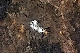 Coropuna (snow-covered) and Wakapallqa (to the right) as seen from the ISS (north is to the upper right part of this image) | |
| Highest point | |
| Elevation | 5,000 m (16,000 ft) [1] |
| Coordinates | 15°28′23″S 72°28′42″W |
| Geography | |
 Wakapallqa Peru | |
| Location | Peru, Arequipa Region, Castilla Province |
| Parent range | Andes |
References
- escale.minedu.gob.pe - UGEL map of the Castilla Province 1 (Arequipa Region)
- Teofilo Laime Ajacopa, Diccionario Bilingüe Iskay simipi yuyayk'ancha, La Paz, 2007 (Quechua-Spanish dictionary)
This article is issued from Wikipedia. The text is licensed under Creative Commons - Attribution - Sharealike. Additional terms may apply for the media files.