Wakefield Street, Adelaide
Wakefield Street is a main thoroughfare intersecting the centre of the South Australian capital, Adelaide from east to west.
Wakefield Street | |
|---|---|
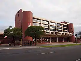 | |
The Metropolitan Fire Station was built in 1983 | |
| General information | |
| Type | Street |
| Length | 1.2 km (0.7 mi)[1] |
| Opened | 1837 |
| Major junctions | |
| Western end | Victoria Square |
| Pulteney Street, Hutt Street | |
| Eastern end | East Terrace |
Location and description
It runs in from east to west between East Terrace and Victoria Square, and is one of the three streets (along with Grote Street and King William Street) to run through Victoria Square in the middle of the Adelaide city centre. The same three streets are also the widest streets in the city centre, at 2 chains (130 ft; 40 m) wide (refer to Adelaide city centre#Layout). The western end of Wakefield Street is continued across Victoria Square as Grote Street, which extends to West Terrace. The eastern end of Wakefield Street continues as Wakefield Road across the Adelaide Park Lands to Britannia Roundabout on the City Ring Route, Adelaide. Wakefield Road continues on the eastern side of the roundabout as Kensington Road.
Buildings on Wakefield Street include (more or less west to east):
- St Francis Xavier's Cathedral, Adelaide
- Adelaide Holocaust Museum and Andrew Steiner Education Centre in the heritage-listed Fennescey House
- St Aloysius College, Adelaide
- SA Police city branch
- The South Australian Metropolitan Fire Service
- Our Boys' Institute building, now a boutique hotel
- Christian Brothers College, Adelaide
- The studios of TV station ADS-10 face on to Wakefield Street (south-east corner), although the address is Hutt Street
History
The street was named after Daniel Bell Wakefield, the solicitor who drafted the Act which proclaimed Adelaide. Like his brother Edward Gibbon Wakefield, he was also involved in the South Australia Association in London, but never visited Adelaide.[2]
In 1911 the Willard Hall and Willard Guest House were opened by the South Australian branch of the WCTU, named after Frances Willard, United States national president of Woman's Christian Temperance Union (WCTU).[3] The building, previously St Andrew's Presbyterian Church, was situated on the south side of the road, 2.75 yards (2.51 m) west of the east side of Gawler Place. In 1928 an old bell was found in the tower, which was probably the first bell cast in Adelaide and made for the church.[4] A 1939 photograph shows the new art deco additions to the building, and the premises of Frank J. Siebert, Funeral Director, on the left.[5]
The Unitarian Christian Church which once stood opposite Francis Xavier's Cathedral was sold to the Public Service Association in 1971.[6] It was replaced with a government building known as the "Wakefield House", a 20-storey building in brutalist style completed in 1980.[7]
Junction list
| Location | km[8] | mi | Destinations | Notes | |
|---|---|---|---|---|---|
| Adelaide city centre | 0 | 0.0 | Victoria Square, King William Street | Continues as Grote Street | |
| 0.2 | 0.12 | Gawler Place | |||
| 0.55 | 0.34 | Pulteney Street | |||
| 0.75 | 0.47 | Frome Street | |||
| 1.1 | 0.68 | Hutt Street | |||
| 1.2 | 0.75 | East Terrace | |||
| 1.000 mi = 1.609 km; 1.000 km = 0.621 mi | |||||
See also
![]() Australian roads portal
Australian roads portal
References
- Google. "Wakefield Street" (Map). Google Maps. Google.
- "Streets of Adelaide and North Adelaide" (PDF). State Library of South Australia. Retrieved 21 May 2016.
- "Women's Christian Temperance Union". Adelaidia. Retrieved 3 July 2019.
- "Wakefield Street, Adelaide [B 6904]: Photograph". State Library of South Australia. Retrieved 3 July 2019.
- "Wakefield Street, Adelaide [B 7386]: Photograph". State Library of South Australia. Retrieved 3 July 2019.
- State Library of South Australia. "Unitarian Church of South Australia" (PDF). SRG 122 Series List. Retrieved 17 June 2020. Cite journal requires
|journal=(help) - "Wakefield House". Emporis. Retrieved 17 June 2020.
- Google (11 December 2016). "Wakefield Street, Adelaide" (Map). Google Maps. Google. Retrieved 11 December 2016.
Streets and squares of Adelaide city centre | |||||||||||||
|---|---|---|---|---|---|---|---|---|---|---|---|---|---|
| |||||||||||||