Wakyaato
Wakyaato is a town in Nakaseke District, Central Uganda. The correct spelling of the town is with two "a"s after the "y". However, some sources have the wrong spelling with one "a".
Wakyaato | |
|---|---|
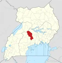
 Wakyaato Map of Uganda showing the location of Wakyaato | |
| Coordinates: 00°52′41″N 32°12′18″E | |
| Country | |
| Region | Central Uganda |
| District | Nakaseke District |
| Constituency | Nakaseke North |
| Government | |
| • Member of Parliament | Syda Bbumba |
| Elevation | 1,080 m (3,540 ft) |
| Time zone | UTC+3 (EAT) |
Location
The town of Wakyaato is located approximately 37.5 kilometres (23.3 mi), by road, west of Luweero, the largest town in the sub-region.[1] This location is approximately 92 kilometres (57 mi), by road, northwest of Kampala, Uganda's capital and largest city.[2] The coordinates of Wakyaato are:00 52 41N, 32 12 18E (Latitude:0.8790;Longitude:32.2000).
Overview
Wakyaato is a small town in northern Nakaseke District. It is the headquarters of Wakyaato Sub-county, one of the eight (8) Sub-counties that constitute the district.[3] The northern part of the district is inhabited predominantly by pastoralist communities, contrasting with the subsistence agriculturalists who inhabit the southern part of Nakaseke District.[4]
Population
The exact population of Wakyaato is not known, as of January 2010.
Landmarks
The landmarks within the town or close to its borders include:
- The offices of Wakyaato Town Council
- The headquarters of Wakyaato Sub-county
- Wakyaato Central Market is the main market
- Wakyaato Health Center III - A health facility administered by the Uganda Ministry of Health
- Wakyaato Prison - A correctional facility administered by the Uganda Prisons Department[5]
External links
References
Capital: Butalangu | ||
| Counties and sub-counties |
|  |
| Towns and villages | ||
| Health | ||
| Notable landmarks |
| |
| Transport | ||
| Education |
| |
| Notable people | ||
