Walchwil
Walchwil is a village and a municipality in the canton of Zug in Switzerland.
Walchwil | |
|---|---|
 | |
 Coat of arms | |
Location of Walchwil 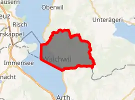
| |
 Walchwil Walchwil | |
| Coordinates: 47°6′N 8°31′E | |
| Country | Switzerland |
| Canton | Zug |
| District | n.a. |
| Government | |
| • Mayor | Stefan Hermann CVP/PDC |
| Area | |
| • Total | 15.9 km2 (6.1 sq mi) |
| Elevation (Railroad station) | 449 m (1,473 ft) |
| Highest elevation (Hagegg (mountain)) | 1,250 m (4,100 ft) |
| Lowest elevation (Lake Zug) | 415 m (1,362 ft) |
| Population (2018-12-31)[2] | |
| • Total | 3,663 |
| • Density | 230/km2 (600/sq mi) |
| Time zone | UTC+01:00 (Central European Time) |
| • Summer (DST) | UTC+02:00 (Central European Summer Time) |
| Postal code(s) | 6318 |
| SFOS number | 1710 |
| Surrounded by | Arth (SZ), (Küssnacht (SZ), Merlischachen (LU)), Unterägeri, Zug |
| Website | www SFSO statistics |
History
Walchwil is first mentioned in 1283 as Walchwile.[3]
Geography

Walchwil has an area, as of 2006, of 13.5 km2 (5.2 sq mi). Of this area, 41.5% is used for agricultural purposes, while 45.5% is forested. Of the rest of the land, 8.2% is settled (buildings or roads) and the remainder (4.7%) is non-productive (rivers, glaciers or mountains).[4]
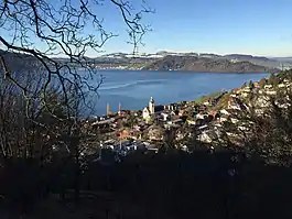
The municipality is located on the eastern shore of Lake Zug on the south side of Zugerberg (1,000 m (3,300 ft)). It consists of the villages of Walchwil and Oberdorf (also known as Emmeten).
Demographics
Walchwil has a population (as of 31 December 2019) of 3,711.[5] As of 2007, 29.9% of the population was made up of foreign nationals. Over the last 10 years the population has grown at a rate of 7.6%. Most of the population (as of 2000) speaks German (82.4%), with English being second most common ( 6.1%) and French being third ( 1.8%).[4]
In the 2007 federal election the most popular party was the CVP which received 35.5% of the vote. The next three most popular parties were the SVP (30.1%), the FDP (16.6%) and the Green Party (10.1%).[4]
In Walchwil about 82% of the population (between age 25-64) have completed either non-mandatory upper secondary education or additional higher education (either university or a Fachhochschule).[4]
Walchwil has an unemployment rate of 1.29%. As of 2005, there were 161 people employed in the primary economic sector and about 46 businesses involved in this sector. 247 people are employed in the secondary sector and there are 29 businesses in this sector. 451 people are employed in the tertiary sector, with 137 businesses in this sector.[4]
The historical population is given in the following table:[3]
| year | population |
|---|---|
| 1771 | 671 |
| 1850 | 1,039 |
| 1900 | 1,059 |
| 1950 | 1,226 |
| 1970 | 1,675 |
| 1990 | 2,654 |
Transportation
The municipality has two railway stations: Walchwil and Walchwil Hörndli. Both are located on the Thalwil–Arth-Goldau line.
References
- "Arealstatistik Standard - Gemeinden nach 4 Hauptbereichen". Federal Statistical Office. Retrieved 13 January 2019.
- "Ständige Wohnbevölkerung nach Staatsangehörigkeitskategorie Geschlecht und Gemeinde; Provisorische Jahresergebnisse; 2018". Federal Statistical Office. 9 April 2019. Retrieved 11 April 2019.
- Walchwil in German, French and Italian in the online Historical Dictionary of Switzerland.
- Swiss Federal Statistical Office accessed 22-Sep-2009
- "Ständige und nichtständige Wohnbevölkerung nach institutionellen Gliederungen, Geburtsort und Staatsangehörigkeit". bfs.admin.ch (in German). Swiss Federal Statistical Office - STAT-TAB. 31 December 2019. Retrieved 6 October 2020.
| Wikimedia Commons has media related to Walchwil. |
External links
- Walchwil in German, French and Italian in the online Historical Dictionary of Switzerland.
Municipalities in the Canton of Zug, Switzerland | ||
|---|---|---|
