Walnut Creek (Central Texas)
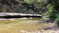
Walnut Creek is a 23-mile (37 km) long tributary stream of the Colorado River in Texas.[1] It flows from north to south, crossing the Edwards Plateau on the western side of Austin, down to the Blackland Prairie on the eastern side of the city where it then drains into the Colorado River downstream of Longhorn Dam.[1] The stream's upper region flows over limestone, while the southern stretch passes through deeper clay soils and hardwood forest.[2] Walnut Creek's watershed, spanning 36,000 acres (15,000 ha), is the largest in Central Austin.[2]
| Walnut Creek ( Central Texas) | |
|---|---|
 | |
| Location | |
| Country | United States |
| Physical characteristics | |
| Source | |
| • location | Edwards Aquifer |
| Mouth | |
• location | Colorado River |
• coordinates | 30°15′44″N 97°38′29″W |
| Length | 23 miles (37 km) |
| Basin size | 36,000 acres (150 km2) |
The creek can be accessed at several local parks, most notably Walnut Creek Metropolitan Park and Balcones District Park.
History
Walnut Creek was inhabited along its length by the Tonkawa in small settlements.[2] In 1833, the stream was the site of the first documented conflict in Travis County between the indigenous natives and settlers when an attack on a settler hunting party resulted in two deaths.[2] However, the Tonkawa soon allied with the American settlers against the larger rival tribes in the region—the Comanche, Kiowa, and Apache—often serving as scouts for the Texas Rangers and U.S. Army.[3]
See also
References
- Scoggins, Mateo (May 2010). "Walnut Creek Update Report" (PDF). City of Austin. Retrieved April 10, 2017.
- "Walnut Creek | AustinTexas.gov - The Official Website of the City of Austin". www.austintexas.gov. Retrieved April 10, 2017.
- "Walnut Creek District Park: Archeological Testing At The Wells Site 41TV368". fryr.tripod.com. Retrieved 2017-04-10.
External links
