Wardsville, Missouri
Wardsville is a village in Cole County, Missouri, United States. The population was 1,506 at the 2010 census. It is part of the Jefferson City, Missouri Metropolitan Statistical Area.
Wardsville, Missouri | |
|---|---|
| Village of Wardsville | |
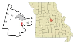 Location of Wardsville, Missouri | |
| Coordinates: 38°29′25″N 92°10′25″W | |
| Country | United States |
| State | Missouri |
| County | Cole |
| Township | Osage |
| Area | |
| • Total | 3.47 sq mi (8.99 km2) |
| • Land | 3.47 sq mi (8.99 km2) |
| • Water | 0.00 sq mi (0.00 km2) |
| Elevation | 781 ft (238 m) |
| Population | |
| • Total | 1,506 |
| • Estimate (2019)[3] | 1,560 |
| • Density | 449.57/sq mi (173.57/km2) |
| Time zone | UTC-6 (Central (CST)) |
| • Summer (DST) | UTC-5 (CDT) |
| ZIP code | 65101 |
| Area code(s) | 573 |
| FIPS code | 29-77002[4] |
| GNIS feature ID | 0728346[5] |
History
A post office called Wardsville was established in 1881, and remained in operation until 1933.[6] The village was named after Junius Ward, the original owner of the town site.[7]
Geography
Wardsville is located at 38°29′25″N 92°10′25″W (38.490408, -92.173616).[8]
According to the United States Census Bureau, the village has a total area of 3.47 square miles (8.99 km2), all land.[9]
Demographics
| Historical population | |||
|---|---|---|---|
| Census | Pop. | %± | |
| 1970 | 460 | — | |
| 1980 | 535 | 16.3% | |
| 1990 | 513 | −4.1% | |
| 2000 | 976 | 90.3% | |
| 2010 | 1,506 | 54.3% | |
| 2019 (est.) | 1,560 | [3] | 3.6% |
| U.S. Decennial Census[10] | |||
2010 census
As of the census[2] of 2010, there were 1,506 people, 516 households, and 416 families living in the village. The population density was 434.0 inhabitants per square mile (167.6/km2). There were 529 housing units at an average density of 152.4 per square mile (58.8/km2). The racial makeup of the village was 97.7% White, 0.6% African American, 0.3% Native American, 0.3% Asian, 0.3% Pacific Islander, and 0.8% from two or more races. Hispanic or Latino of any race were 0.5% of the population.
There were 516 households, of which 49.8% had children under the age of 18 living with them, 66.5% were married couples living together, 9.9% had a female householder with no husband present, 4.3% had a male householder with no wife present, and 19.4% were non-families. 16.9% of all households were made up of individuals, and 8% had someone living alone who was 65 years of age or older. The average household size was 2.92 and the average family size was 3.28.
The median age in the village was 35.3 years. 33% of residents were under the age of 18; 6.8% were between the ages of 18 and 24; 26.2% were from 25 to 44; 24.7% were from 45 to 64; and 9.4% were 65 years of age or older. The gender makeup of the village was 48.5% male and 51.5% female.
2000 census
As of the census[4] of 2000, there were 976 people, 343 households, and 276 families living in the village. The population density was 402.4 people per square mile (155.1/km2). There were 347 housing units at an average density of 143.1 per square mile (55.1/km2). The racial makeup of the village was 99.59% White, 0.10% Native American, and 0.31% from two or more races. Hispanic or Latino of any race were 0.31% of the population.
There were 343 households, out of which 45.5% had children under the age of 18 living with them, 72.0% were married couples living together, 6.4% had a female householder with no husband present, and 19.5% were non-families. 17.5% of all households were made up of individuals, and 8.5% had someone living alone who was 65 years of age or older. The average household size was 2.85 and the average family size was 3.23.
In the village, the population was spread out, with 31.4% under the age of 18, 6.4% from 18 to 24, 30.9% from 25 to 44, 21.3% from 45 to 64, and 10.0% who were 65 years of age or older. The median age was 35 years. For every 100 females, there were 97.6 males. For every 100 females age 18 and over, there were 96.5 males.
The median income for a household in the village was $57,813, and the median income for a family was $62,188. Males had a median income of $37,361 versus $28,482 for females. The per capita income for the village was $21,925. About 1.5% of families and 1.9% of the population were below the poverty line, including 1.0% of those under age 18 and 5.4% of those age 65 or over.
References
- "2019 U.S. Gazetteer Files". United States Census Bureau. Retrieved July 26, 2020.
- "U.S. Census website". United States Census Bureau. Retrieved 2012-07-08.
- "Population and Housing Unit Estimates". United States Census Bureau. May 24, 2020. Retrieved May 27, 2020.
- "U.S. Census website". United States Census Bureau. Retrieved 2008-01-31.
- "US Board on Geographic Names". United States Geological Survey. 2007-10-25. Retrieved 2008-01-31.
- "Post Offices". Jim Forte Postal History. Retrieved 22 September 2016.
- "Cole County Place Names, 1928–1945 (archived)". The State Historical Society of Missouri. Archived from the original on 24 June 2016. Retrieved 22 September 2016.
- "US Gazetteer files: 2010, 2000, and 1990". United States Census Bureau. 2011-02-12. Retrieved 2011-04-23.
- "US Gazetteer files 2010". United States Census Bureau. Retrieved 2012-07-08.
- "Census of Population and Housing". Census.gov. Retrieved June 4, 2015.
Municipalities and communities of Cole County, Missouri, United States | ||
|---|---|---|
| Cities | 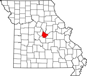 Map of Missouri highlighting Cole County | |
| Villages | ||
| Townships | ||
| Unincorporated communities | ||
| Ghost towns | ||
| Footnotes | ‡This populated place also has portions in an adjacent county or counties | |
| ||