Washington State Route 213
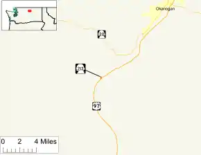
State Route 213 (SR 213) is the shortest state highway in the U.S. state of Washington. The 0.35-mile (0.56 km) long unsigned highway serves Malott, a community in Okanogan County. Extending from U.S. Route 97 (US 97) over the Okanogan River via a bridge to First Avenue in Malott, the roadway is semi-complete, as state law designates that the road should extend to SR 20 southwest of Okanogan. First appearing in a map in 1954, SR 213 originated as a branch of Primary State Highway 16 (PSH 16) in 1959 and later SR 20 Spur in 1964. SR 20 Spur became SR 213 in 1973 because another SR 20 Spur was recently established in Anacortes.
| ||||
|---|---|---|---|---|
 The present route of SR 213 is highlighted in red. | ||||
| Route information | ||||
| Auxiliary route of SR 20 | ||||
| Defined by RCW 47.17.417 | ||||
| Maintained by WSDOT | ||||
| Length | 0.35 mi[1] (0.56 km) | |||
| Existed | 1973[2]–present | |||
| Major junctions | ||||
| South end | ||||
| North end | First Avenue in Malott (temporary) | |||
| Highway system | ||||
| ||||

Route description

SR 213 originates at an intersection with U.S. Route 97 (US 97) south of Malott. Traveling northwest and turning northeast, the unsigned roadway crosses the Cascade and Columbia River Railroad and the Okanogan River near the confluence of the Okanogan River and Loup Loup Creek.[3][4] After crossing the Okanogan River, the highway enters Malott and terminates at First Avenue,[5][6] although state law dictates that eventually the road will be extended to SR 20 southwest of Okanogan.[2] An estimated daily average of 740 motorists utilized SR 213 in 2008.[7]
History
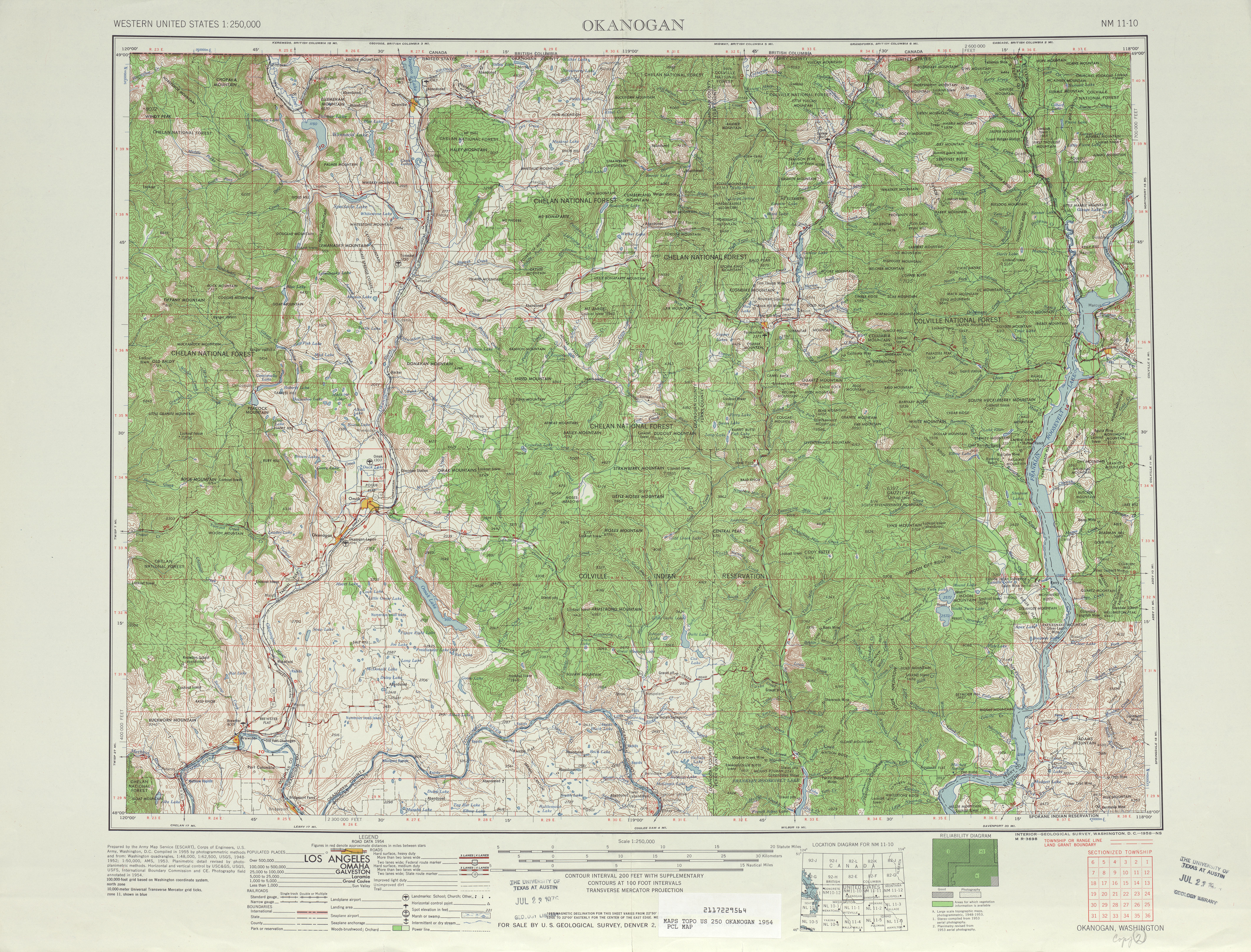
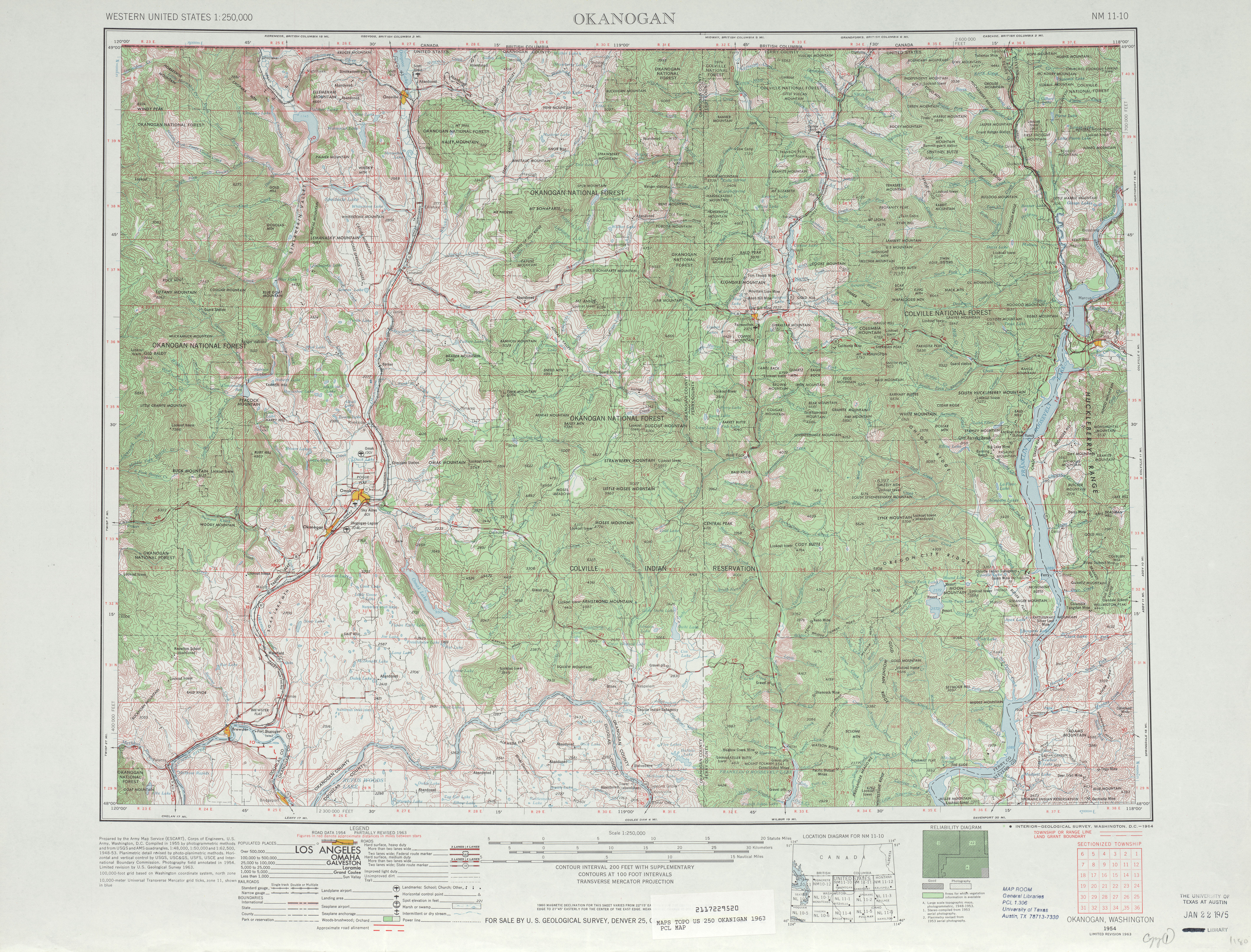
SR 213 originated as a minor road that connected U.S. Route 97 (US 97) to the area south of the Okanogan River and Malott; the road first appeared on a map in 1954.[8] In 1959, the Washington State Legislature passed a law that created a branch of Primary State Highway 16 (PSH 16) that extended from PSH 16 near Okanogan to US 97 in Malott to take effect on July 1, 1961.[9][10] By 1963, US 97 was realigned south of the Okanogan River and the PSH 16 branch was extended across the river.[11] During a highway renumbering in 1964, PSH 16 became SR 20 and the branch of PSH 16 became SR 20 Spur.[12] In 1973, SR 20 Spur became SR 213, while another SR 20 Spur was established in Anacortes.[2][13] Beginning in 2008, the Washington State Department of Transportation (WSDOT) has been maintaining a short, 0.35-mile (0.56 km) long segment of the proposed SR 213 as the a state route.[1][14] The highway between Malott and SR 20 will be eventually built as state law dictates it.[2]
Major intersections
The entire highway is in Okanogan County.
| Location | mi[1] | km | Destinations | Notes | |
|---|---|---|---|---|---|
| | 0.00 | 0.00 | Southern terminus | ||
| Okanogan River | 0.19 | 0.31 | Bridge over Okanogan River | ||
| Malott | 0.35 | 0.56 | First Avenue | Temporary northern terminus | |
| 1.000 mi = 1.609 km; 1.000 km = 0.621 mi | |||||
References
- Washington State Department of Transportation (2008). "State Highway Log: Planning Report, SR 2 to SR 971" (PDF). Retrieved August 12, 2009.
- Washington State Legislature (1973). "RCW 47.17.417: State route No. 213". Retrieved August 12, 2009.
- Washington State Rail System (PDF) (Map). Washington State Department of Transportation. 2008. Retrieved August 12, 2009.
- Pacific Northwest: Washington, Oregon, Western Idaho, Southwestern British Columbia (Map) (6th ed.). 1 inch = 3,800 feet. The Thomas Guide. Cartography by NAVTEQ. Thomas Bros., Rand McNally. 2004. p. 104. § C3. ISBN 0-528-99511-1.
- Google (August 12, 2009). "State Route 213" (Map). Google Maps. Google. Retrieved August 12, 2009.
- Washington State Highways, 2008–2009 (PDF) (Map) (2008–09 ed.). 1:842,000. Cartography by United States Geological Survey. Washington State Department of Transportation. 2008. § C6. Retrieved August 12, 2009.
- Washington State Department of Transportation (2008). "2008 Annual Traffic Report" (PDF). Retrieved August 12, 2009.
- Okanogan, 1954 (Map). Cartography by United States Geological Survey. University of Texas at Austin. 1954. Retrieved August 12, 2009.
- Washington State Legislature. "Chapter 319". Session Laws of the State of Washington. Session Laws of the State of Washington (1959 ed.). Olympia, Washington: Washington State Legislature.
- Washington State Legislature (July 1, 1961). "Chapter 13: Public Highways". Session Laws of the State of Washington. Session Laws of the State of Washington (1961 ed.). Olympia, Washington: Washington State Legislature. p. 520. Retrieved August 12, 2009.
47.16.160 No. 16 Methow Valley highway. (Effective July 1, 1961.) A primary state highway to be known as primary state highway No. 16, or the Methow Valley highway, is hereby established according to description as follows: Beginning in the vicinity of Pateros on primary state highway No. 10, thence in a northerly direction by the most feasible route by way of Twisp to Mazama; also beginning at a point in the vicinity south of Twisp on primary state highway No. 16, thence in an easterly direction by the most feasible route to a junction with primary state highway No. 10 in the vicinity south of Okanogan; also, beginning at a wye connection with primary state highway No. 16, southwest of Okanogan, thence southwesterly to a junction with primary state highway No. 10 in the vicinity of Malott: Provided, That until such times as primary state highway No. 16 from southwest of Okanogan to the vicinity of Malott is actually constructed on the location adopted by the highway commission, no existing county roads shall be maintained or improved by the highway commission as a temporary route of said primary state highway No. 16. This section shall become effective July 1, 1961.
- Okanogan, 1963 (Map). Cartography by United States Geological Survey. University of Texas at Austin. 1963. Retrieved August 12, 2009.
- C. G. Prahl (December 1, 1965). "Identification of State Highways" (PDF). Washington State Highway Commission, Department of Highways. Retrieved August 12, 2009.
- Washington State Legislature (1973). "RCW 47.17.081: State route No. 20 north". Retrieved August 12, 2009.
- Washington State Department of Transportation (2007). "State Highway Log: Planning Report, SR 2 to SR 971" (PDF). Archived from the original (PDF) on June 16, 2010. Retrieved August 12, 2009.