Washington State Route 706
State Route 706 (SR 706, also known as the Road to Paradise[2]) is a state highway in Pierce County, in the U.S. state of Washington. It extends 13.64 miles (21.95 km) from SR 7 in the census-designated place (CDP) of Elbe east to the Longmire gate of Mount Rainier National Park.
| ||||
|---|---|---|---|---|
| Road to Paradise | ||||
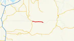
 SR 706 highlighted in red. | ||||
| Route information | ||||
| Auxiliary route of SR 7 | ||||
| Defined by RCW 47.17.820 | ||||
| Maintained by WSDOT | ||||
| Length | 13.64 mi[1] (21.95 km) | |||
| Existed | 1964[2]–present | |||
| Major junctions | ||||
| West end | ||||
| East end | ||||
| Highway system | ||||
| ||||
The highway was part of the Tacoma – Mount Rainier branch of Primary State Highway 5 (PSH 5 TR) from 1937 until 1964 and ran from Tacoma south to Elbe and east to Longmire. In 1964, PSH 5 TR from Tacoma to Elbe became part of SR 7 and the Elbe to Mount Rainier section became SR 706.
Route description
SR 706 runs 13.64 miles (21.95 km) from an intersection with SR 7 in the census-designated place (CDP) of Elbe, east to end at the Longmire gate of Mount Rainier National Park (Mount Rainier NP).[3][4] The route serves as a connector from Elbe to Mount Rainier NP.[3] The highway is open all-year and the entrance to Mount Rainier National Park is open all-year round, unlike other entrances that are open only in the summer.[5] WSDOT has found that more than 3,100 motorists utilize the road daily after the interchange with I-5 based on annual average daily traffic (AADT) data.[6]
SR 706 starts at an intersection with SR 7 in Elbe. After the junction, the road goes northeast, paralleling a railroad owned by Tacoma Rail.[7][8] The railroad extends south to Morton and north to Tacoma.[7] The highway then turns southeast to Park Junction. After passing Park Junction, SR 706 turns due east to National, where the railroad ends. From National, the road turns northeast and curves southeast into Ashford. In Ashford, the highway returns going due east before starting to curve and then end at the entrance to Mount Rainier National Park.[3][9] The road continues east to the Henry M. Jackson Visitor Center.[10]
History

When the Primary and Secondary Highways were created in 1937, the route of SR 706 became part of the Tacoma – Mount Rainier branch of Primary State Highway 5 (PSH 5 TR).[11] PSH 5 TR ran from Primary State Highway 1 (PSH 1) in Tacoma south to Elbe and east to Longmire.[11] PSH 5 TR became SR 706 in 1964 during the 1964 highway renumbering, in which the Washington State Department of Transportation (WSDOT) replaced the previous system of Primary and Secondary Highways with a new system called State Routes, which is still in use today.[12][13] In 1990, the Washington State Legislature named the highway the Road to Paradise, to recognize the community of Paradise and the Paradise Inn.[2]
Major intersections
The entire route is in Pierce County.
| Location | mi[1] | km | Destinations | Notes | |
|---|---|---|---|---|---|
| Elbe | 0.00 | 0.00 | |||
| Gifford Pinchot NF | 10.14 | 16.32 | Entering Gifford Pinchot NF | ||
| Longmire | 13.64 | 21.95 | |||
| 1.000 mi = 1.609 km; 1.000 km = 0.621 mi | |||||
References
- Washington State Department of Transportation. "State Highway Log, 2006" (pdf). Retrieved November 22, 2008.
- Washington State Legislature. "RCW 47.17.820: State Route 706 – Road to Paradise". Retrieved November 22, 2008.
- Google (November 20, 2015). "State Route 706" (Map). Google Maps. Google. Retrieved November 20, 2015.
- Mount Rainier Nat'l Park, WA 217 (Map). Cartography by National Geographic. Trails Illustrated. 2003. Retrieved November 22, 2008.
- U.S. Geological Survey. "Mount Rainier National Park". Retrieved November 22, 2008.
- Washington State Department of Transportation (2007). "Washington Annual Average Daily Traffic Data" (PDF). Retrieved November 22, 2008.
- Washington State Railroad System (PDF) (Map). Cartography by U.S. Geological Survey. Washington State Department of Transportation. August 2007. Retrieved November 22, 2008.
- Washington State Department of Transportation. "Railroad Contacts in Washington State". Retrieved November 22, 2008.
- Official State Highway Map (PDF) (Map) (2008-2009 ed.). 1:842,000. Official State Highway Maps. Cartography by U.S. Geological Survey. Olympia, Washington: Washington State Department of Transportation. 2008. § G3. Retrieved November 22, 2008.
- Best Western. "Fertile Valley: Mount Rainier National Park" (PDF). Retrieved November 22, 2008.
- Washington State Legislature (1937). "207". Session Laws of the State of Washington. Session Laws of the State of Washington (1937 ed.). Olympia, Washington: Washington State Legislature. p. 997. Retrieved November 9, 2008.
- C. G. Prahl, Washington State Highway Commission (December 1, 1965). "Identification of State Highways, Part 1" (PDF).
- C. G. Prahl, Washington State Highway Commission (December 1, 1965). "Identification of State Highways, Part 2" (PDF).
External links
| Wikimedia Commons has media related to Washington State Route 706. |
