Washington Township, Morgan County, Indiana
Washington Township is one of fourteen townships in Morgan County, Indiana, United States. As of the 2010 census, its population was 17,073 and it contained 7,171 housing units.[1] The township contains a portion of the Morgan–Monroe State Forest.
Washington Township | |
|---|---|
 Intersection of State Highways 37 and 252 in Washington Township | |
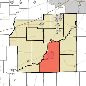 Location in Morgan County | |
| Coordinates: 39°24′22″N 86°24′54″W | |
| Country | |
| State | |
| County | Morgan |
| Government | |
| • Type | Indiana township |
| Area | |
| • Total | 59.03 sq mi (152.9 km2) |
| • Land | 57.51 sq mi (149.0 km2) |
| • Water | 1.51 sq mi (3.9 km2) 2.56% |
| Elevation | 604 ft (184 m) |
| Population (2010) | |
| • Total | 17,073 |
| • Density | 296.9/sq mi (114.6/km2) |
| Time zone | UTC-5 (Eastern (EST)) |
| • Summer (DST) | UTC-4 (EDT) |
| ZIP codes | 46151, 46160 |
| GNIS feature ID | 454008 |
History
The Cross School, Grassyfork Fisheries Farm No. 1, and Long Schoolhouse are listed on the National Register of Historic Places.[2][3]
Geography
According to the 2010 census, the township has a total area of 59.03 square miles (152.9 km2), of which 57.51 square miles (149.0 km2) (or 97.43%) is land and 1.51 square miles (3.9 km2) (or 2.56%) is water.[1] The White River defines the township's north border.
Cities, towns, villages
Unincorporated towns
- Champlin Meadows at 39.407547°N 86.436662°W
- Elk at 39.445881°N 86.429162°W
- Fewell Rhoades at 39.421437°N 86.399438°W
- Mahalasville at 39.360326°N 86.362771°W
- Maxwell at 39.38727°N 86.455551°W
- McDaniel at 39.411992°N 86.440828°W
- Prather at 39.378103°N 86.455273°W
- Shelburne at 39.435325°N 86.392772°W
- Stines Mill Corner at 39.475881°N 86.372771°W
- Taggart Crossing at 39.379214°N 86.40055°W
- Willowbrook Estates at 39.477548°N 86.364993°W [4]
- Wolff at 39.433103°N 86.395272°W
- Woodcrest at 39.437548°N 86.394716°W
(This list is based on USGS data and may include former settlements.)
Cemeteries
The township contains these four cemeteries: Hill Dale, Maxwell, Nutter and Williams.
Major highways
Airports and landing strips
- McDaniels Field
Lakes
- Spring Lake
School districts
- Metropolitan School District of Martinsville Schools
Political districts
- Indiana's 4th congressional district
- State House District 47
- State Senate District 37
References
- "Washington Township, Morgan County, Indiana". Geographic Names Information System. United States Geological Survey. Retrieved 2009-09-26.
- United States Census Bureau 2008 TIGER/Line Shapefiles
- IndianaMap
- "Population, Housing Units, Area, and Density: 2010 - County -- County Subdivision and Place -- 2010 Census Summary File 1". United States Census. Archived from the original on 2020-02-12. Retrieved 2013-05-10.
- "National Register Information System". National Register of Historic Places. National Park Service. July 9, 2010.
- "National Register of Historic Places Listings". Weekly List of Actions Taken on Properties: 7/09/12 through 7/13/12. National Park Service. 2012-07-20.
- "Willowbrook Estates, Indiana". Geographic Names Information System. United States Geological Survey. Retrieved 2017-06-04.
External links
- Indiana Township Association
- United Township Association of Indiana
- City-Data.com page for Washington Township
Places adjacent to Washington Township, Morgan County, Indiana | |
|---|---|
Municipalities and communities of Morgan County, Indiana, United States | ||
|---|---|---|
| City | Map of Indiana highlighting Morgan County | |
| Towns | ||
| Townships | ||
| CDP | ||
| Other unincorporated communities |
| |
| Footnotes | ‡This populated place also has portions in an adjacent county or counties | |
| ||
