Wauhillau, Oklahoma
Wauhillau is a census-designated place (CDP) in Adair County, Oklahoma, United States. The population was 345 at the 2010 census.[3]
Wauhillau, Oklahoma | |
|---|---|
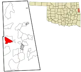 Location within Adair County and the state of Oklahoma | |
| Coordinates: 35°51′25″N 94°46′23″W | |
| Country | United States |
| State | Oklahoma |
| County | Adair |
| Area | |
| • Total | 7.93 sq mi (20.55 km2) |
| • Land | 7.90 sq mi (20.45 km2) |
| • Water | 0.04 sq mi (0.10 km2) |
| Elevation | 820 ft (250 m) |
| Population (2010) | |
| • Total | 345 |
| • Density | 44/sq mi (16.9/km2) |
| Time zone | UTC-6 (Central (CST)) |
| • Summer (DST) | UTC-5 (CDT) |
| FIPS code | 40-79150[1] |
| GNIS feature ID | 2584395[2] |
Geography
Wauhillau occupies a large rural area in western Adair County and is centered at 35°51′25″N 94°46′23″W. Oklahoma State Highway 51 forms the northeastern edge of the CDP. It is 11 miles (18 km) west of Stilwell, the county seat, and 16 miles (26 km) southeast of Tahlequah in Cherokee County.
According to the United States Census Bureau, the CDP has a total area of 7.93 square miles (20.55 km2), of which 7.90 square miles (20.45 km2) is land and 0.039 square miles (0.10 km2), or 0.48%, is water.[3]
References
- "U.S. Census website". United States Census Bureau. Retrieved 2008-01-31.
- "US Board on Geographic Names". United States Geological Survey. 2007-10-25. Retrieved 2008-01-31.
- "Geographic Identifiers: 2010 Demographic Profile Data (G001): Wauhillau CDP, Oklahoma". U.S. Census Bureau, American Factfinder. Archived from the original on February 12, 2020. Retrieved July 12, 2013.
Municipalities and communities of Adair County, Oklahoma, United States | ||
|---|---|---|
| City | 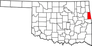 Adair County map | |
| Towns | ||
| CDPs | ||
| Other unincorporated communities | ||
| Indian reservation | ||
| Footnotes | ‡This populated place also has portions in an adjacent county or counties | |
| ||
This article is issued from Wikipedia. The text is licensed under Creative Commons - Attribution - Sharealike. Additional terms may apply for the media files.